Transcription of IMPORTANT FACTS ABOUT LAND DESCRIPTIONS
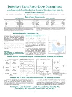
1 6 IMPORTANT FACTS ABOUTLAND DESCRIPTIONSLand Measurements, Townships, Sections, Meandered Water, Government Lots, is a land Description?A land description is a description of a tract of land in legally acceptable terms, so as to show exactly where it is located and how many acres it of land MeasurementsLINEAR MEASURESQUARE MEASURE1 inch ..0833 foot7 .92 inches ..1 link12 inches ..1 foot1 vara ..33 inches2 feet ..1 vara3 feet ..1 yard25 links ..16 feet25 links ..1 rod100 links ..1 chain16 feet ..1 rod5 yards ..1 rod4 rods ..100 links66 feet ..1 chain80 chains ..1 mile320 rods ..1 mile8000 links ..1 mile5280 feet ..1 mile1760 yards ..1 mile144 sq . in ..1 sq .ft .9 sq . ft ..1 sq . yd .30 sq . yds ..1 sq . rod16 sq . rods.
2 1 sq . chain1 sq . rod ..272 sq . ft .1 sq . chain ..4356 sq . ft .10 sq . chains ..1 acre160 sq . rods ..1 acre4840 sq . yds ..1 acre43560 sq . ft ..1 acre640 acres ..1 sq . mile1 sq . mile ..1 section36 sq . miles ..1 township6 miles sq ..1 township208 ft . 8 in . sq ..1 acre80 rods sq ..40 acres160 rods sq ..160 acresMEANDERED FT660 FTFIGURE1160 RODS40 CHAINS4000 LINKS1/2 MILENW 1/4NE 1/4SE 1/4SW 1/4 NORTHSOUTHEASTWEST880 RODS1320 FEET440 CHAINS1/4 MILESW1/4 NW1/4NW1/4 SW1/4NE1/4 SW1/4NW1/4 SE1/4NE1/4 SE1/4SW1/4 SW1/4SE1/4 SW1/4SW1/4 SE1/4SE1/4 SE1/4SE1/4 NW1/4SW1/4 NE1/4SE1/4 NE1/4N1/2 N1/2 SW1/4N1/2NE1/4 SE1/4N1/2 SW1/4 SW1/4S1/2NE1/4SE1/4S1/2 N1/2 SW1/4NE1/4 NW1/4NW1/4 NW1/4NW1/4 NE1/4NE1/4 NE1/41 MILE - 320 RODS - 5280 FEET - 80 CHAINSN1/2N1/2 SW1/4E1/2E1/2NW1/4W1/2NW1/4W1/2NW1/4SE1/ 4E1/2NW1/4SE1/4SE1/4 SW1/4S1/2 SE1/4W1/2SW1/4SW1/4SW1/4SW1/4NE1/4SW1/4S E1/4NW1/4SW1/4SE1/4NE1/4SW1/4SW1/4SE1/4S W1/4SE1/4SW1/4SW1/4SE1/4SE1/410E1/2 SE1/4 SW1/4 SW1/4 - 5 ACRESW1/2 SE1/4 SW1/4 SW1/4 - 5
3 ACRESN1/2SW1/4SW1/4SW1/4 - 5 ACRESS1/2SW1/4SW1/4SW1/4 - 5 ACRES1010160 ACRES40404040404040404040404040404040320 32040404020202020202080808080160 ACRES160 ACRES160 ACRESFIGURE2 FIGURE3 FIGURE4 FIGURE5 Meandered Water & Government LotsA meandered lake or stream is water, next to which the adjoining landowner pays taxes on the land only. Such land is divided into divisions of land called government lots. The location, acreage and lot number of each such a tract of land , was determined, surveyed and platted by the original government original survey of your county (complete maps of each township, meandered lakes, government lots, etc.) is in your courthouse, and this original survey is the basis for all land DESCRIPTIONS in your county (see figure1).
4 IMPORTANT :THE GOVERNMENT LOT NUMBER GIVEN TO APIECE OF land , IS THE LEGAL DESCRIPTION OF THAT TRACT OF CAN YOU TELL WHETHER WATER IS MEANDERED OR PRIVATELY OWNED?On our township maps, if you find government lots adjoining a body of water or stream, those waters are meandered. If there are no government lots surrounding water, that water is privately owned, the owner is paying taxes on the land under the water, and the owner controls the hunting, fishing, trapping rights, etc., on that water, within the regulations of the State and Federal laws, EXCEPT where such water is deemed navigable, other rulings may sometimes a generality (but not always), meandered water is public water which the public may use for recreational purposes, fishing, hunting, trapping, etc.
5 , provided that there is legal access to the water, or in other words, if the public can get to such waters without trespassing. There still is much litigation concerning the same to be decided by the non-rectangular land DESCRIPTIONS , distance is usually described in terms of either feet or rods (this is especially true in surveying today), and square measure in terms of acres. Such DESCRIPTIONS are called Metes and Bounds DESCRIPTIONS and will be explained in detail later. In rectangular land DESCRIPTIONS , square measure is again in terms of acres, and the location of the land in such terms as N (north one-half), SE (south east one-fourth or quarter), etc. as shown in figures 2, 3, 4 and Sections Showing Rectangular land DESCRIPTIONS , Acreages and DistancesThe Best Way To Read land DESCRIPTIONS Is From The Rear Or BackwardsTo Interpret A land Description - Locate The Area On Your Township Plat,Then Analyze The Description & Follow It On The Plat of land always read FIRST from either the North or the South.
6 In figures 2, 3, 4 and 5, notice that they all start with N (north), S (south), such as NW, SE, etc. They are never WN (west north), ES (east south) etc. IMPORTANT : It is comparatively simple for anyone to understand a description, that is, determine where a tract of land is located, from even a long description. The SECRET is to read or analyze the description from the rear or : Under figure 4, the first description read E , SE , SW , SW . The last part of the description reads SW , which means that the tract of land we are looking for is somewhere in that quarter (as shown in figure 2). Next back we find SW , which means the tract we are after is somewhere in the SW SW (as shown in figure 3).
7 Next back, we find the SE , which means that the tract is in the SE SW SW (as shown in figure 5). Next back and our last part to look up, is the E of the above,which is the location of the tract described by the whole description (as shown in figure 4).7 TownshipsTheoretically, a township is a square tract of land with sides of six miles each, and containing 36 sections of land . Act-ually this is not the case. Years ago, when the original sur-vey of this state was made by the government engineers, they knew that it was impossible to keep a true north and south direction of township lines, and still keep getting township squares of 36 square miles.
8 As they surveyed toward the north pole, they were constantly running out of land , because the township lines were converging toward the north you will turn to one of the township maps in this plat book, you will notice that on the north and on the west of each township, there are divisions of land which show odd acreages. In some townships, these odd acreages are called government lots (because they were given a lot number), and at other times left as FRACTIONAL FORTIES OR EIGHTIES. It was at the option of the original government surveyors as to whether they would call these odd acreages government lots, or fractional forties and reason for these odd acreages is that the government surveyors adjusted for shortages of land which developed as they went north, by making fractional forties, eighties or government lots out of the land on the west side of a township, and the same for the land on the north side of a township to keep east and west lines running parallel.
9 In other words it was impossible to fit full squares into a sometimes vary in size from the regularly laid-out township (see figure 6). Suppose that the dotted line in figure 6 is a river separating two counties. The land north and west of the river could be a township in one county, the land south and east could be a township in another county. Whichever county the land is in, it still retains the same section, township and range numbers for purposes of land township has a township number and also a range number (sometimes more than one of each if the township is oversized, or a combination of more than one township and range).Government surveying of townships is run from starting lines called base lines and principal meridians.
10 Each township has a township number. This number is the number of rows or tiers of townships that a township is either north or south of the base line. Also each township has a range number. This number is the number of rows or tiers of townships that a township is either east or west of the principal meridian (see figure 7). EVERY DESCRIPTION OF land SHOULD SHOW THE SECTION, TOWNSHIP AND RANGE IT IS LOCATED FACTS ABOUTLAND DESCRIPTIONS6543211211109871817161514132 42322212019302928272625363534333231 NORTHSOUTHEASTWEST4WT2NR4WT2NR3ET3SR3WT2 SR2E4N1S3N2S2N3S1N4S3W2W1W1E2E3E4 EBASEPRINCIPALMERIDIANLINETOWNSHIP NUMBERSRANGE NUMBERSARE NUMBERED IN A TOWNSHIPDIAGRAM SHOWING HOW SECTIONSFIGURE6 FIGURE7A Congressional TownshipContains 36 Sections Of Land1 Mile SquareA Civil Or Political TownshipMay Be Larger Or Smaller Than A Congressional May Be Either North Or South Of The Base LineRanges May Be Either East Or West Of The Principal And Bounds DescriptionsAnd Explanation Of Direction In Terms Of DegreesWHAT IS A METES AND BOUNDS DESCRIPTION?