Transcription of Inlet Area Map & Guide - Adirondack Experience
1 1. trail to Rondaxe Mountain Fire Tower (Bald Mountain) Halfway between Inlet & Old Forge on Route 28, turn onto Ron-daxe Road, travel .2 miles and the parking and trailhead are on the left. The trail is intermediate and the peak can be reached by a brisk 30-minute hike. This parking also allows access for trailheads to Fly Pond .3 miles, Carry Pond .6 miles, the Railroad Bed .7 miles and the spur trail to Mountain Pond miles. 2. Scenic trail to Rondaxe Road The trail is about miles long (easy). The DEC has put in a new parking area at this location which also allows access to Bubb Lake .8 miles, Sis Lake miles and the spur trail to Mountain Pond. 3. trail to Moss Lake Off of Route 28 turn onto the Big Moose Road in Eagle Bay, travel miles and use the parking on the left.
2 There are two separate parking areas. The trail around the lake is easy and 3 miles. This also serves as the trailhead to Bubb Lake miles and Sis Lake miles. 4. trail to Cascade Lake Off of Route 28 turn onto the Big Moose Road in Eagle Bay, travel miles to the trailhead parking on the right. The trail to the lake is 2 miles (easy) and to Cascade Falls is 3 miles (easy). A spur trail continues to Queer Lake miles (intermediate). 5. trail to Rocky Mountain Summit On Route 28, just south of downtown Inlet . From the trailhead to the top it is .6 miles of intermediate climb. Parking area is also used for Black Bear Mountain. 6. trail to Black Bear Mountain Summit On Route 28, just south of downtown Inlet . The trailhead is all the way to the right of the parking lot.
3 From the trailhead to the summit is miles (steeper intermediate) or you can take the steeper, more difficult miles. Parking area is also used for Rocky Mountain. 7. Uncas Black Bear Mountain trail Take the Uncas Road off Route 28 near Eagle Bay, travel 4 miles parking on the right. Look for signs for the ski trail access. to the top of the mountain (intermediate). trail also continues to Bug Lake miles and Eagle s Nest Pond miles. 8. trail to Bug Lake and Eagle s Nest 5 miles north of Inlet , on Route 28, enter the Eighth Lake Campground. trail to Bug Lake miles (easy) and to Eagle s Nest Pond 1 mile. Look for ski trail markers to continue to Black Bear Mountain miles. 9. Self-Guided Nature trail Enter the Limekiln Road from Route 28, north of down town Inlet , travel 2 miles to the Limekiln Campground entrance.
4 Pay the day use fee. Self-guided nature trail brochure at trail -head, miles (easy). Also access to the trail to Limekiln Falls 3 miles (intermediate) and Third Lake 8 miles. 10. Cathedral Pines 3 miles north of Inlet on Route 28, watch for small pull off on the right at the end of a long straight stretch. Trailhead is across the road. The trail is .5 miles (easy). Trailhead may be difficult to find, it has a small worn sign. 11. Ferd s Bog Turn onto the Uncas Road from Route 28 near Eagle Bay, travel miles and use left shoulder. The trail is .4 miles - half trail , half floating boardwalk. 12. Fern Park Turn on to the South Shore Road in Inlet , travel .2 miles and take a left on Loomis Road. Trails vary in range from easy to difficult.
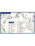
5 Maps are avail-able at the trailhead and at the Inlet Information Office. Inlet area Hiking Trails Map & Guide Inlet Information Office PO Box 266, Inlet NY 13360 1-866-GO Inlet 315-357-5501 Fax: 315-357-3570 Tourism: Government: Events: Ferd s Bog Rt. 28 Limekiln Falls Limekiln Campground Moose River Recreation area Cathedral Pines Eighth Lake Campsite Bug Lake & Eagle s Nest Pond Shallow Lake Rt. 28 Old Forge Bald Mt. 0 2 4 6 Scale in Miles Let others know of your trip route Dial 911 For Emergencies Town of Inlet Hiking Map N Dart Lake Moss Lake Bubb Lake Sis Lake Rondaxe Lake Mountain Pond Queer Lake Cascade Lake Rocky Mt. Black Bear Mt.
6 Downtown Inlet Seventh Lake Eighth Lake Uncas Rd. Eagle Bay Fourth Lake South Shore Rd. Third Lake First Lake Limekiln Lake Brown Tract Ponds Nature trail Fern Park Carry Pond 2 3 4 5 6 12 11 7 10 Big Moose Big Moose Rd. Cascade Falls This brochure was printed by the Inlet Information Office 3/07 Browns Tract Campground 1 9 8