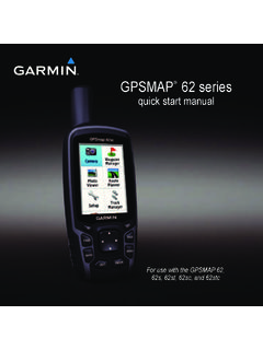
Transcription of INREACH SE+ / Owner’s Manual INREACH EXPLORER
1 INREACH SE + INREACH EXPLORER +Owner s Manual 2017 Garmin Ltd. or its subsidiariesAll rights reserved. Under the copyright laws, this Manual may not be copied, in whole or in part, without the written consent of Garmin. Garmin reserves the right to change or improve its products and to make changes in the content of this Manual without obligation to notify any person or organization of such changes or improvements. Go to for current updates and supplemental information concerning the use of this , the Garmin logo, Earthmate , and INREACH are trademarks of Garmin Ltd. or its subsidiaries, registered in the USA and other countries. MapShare is a trademark of Garmin Ltd. or its subsidiaries. These trademarks may not be used without the express permission of Bluetooth word mark and logos are owned by the Bluetooth SIG, Inc. and any use of such marks by Garmin is under license. Facebook and the Facebook logo are trademarks of Facebook and its affiliate companies. Iridium is a registered trademark of Iridium Satellite LLC.
2 TWITTER and the Twitter logo are trademarks of Twitter, Inc. or its affiliates. Other trademarks and trade names are those of their respective of ContentsGetting On the the the Satellite Connected Your Mobile the a Preset a Text to a to Social for Message to a Message Location Coordinates in a a a a an SOS a Custom SOS an SOS GPS Satellite a Weather a Weather a Weather a Weather a Weather Use and Data Data the and Altimeter Power the Device Owner and the Carabiner a and Unlocking the of ContentsiGetting Started WARNINGSee the Important Safety and Product Information guide in the product box for product warnings and other important Overview Internal Iridium antenna SOS key (under protective cap) Status LED Keys Power key Mounting spine Micro-USB port (under weather cap)Turning On the DeviceHold .Charging the DeviceNOTICETo prevent corrosion, thoroughly dry the USB port, the weather cap, and the surrounding area before charging or connecting to a : The device does not charge when it is outside the approved temperature range (Specifications, page 8).
3 1 Lift the weather cap .2 Plug the small end of the power cable into the USB port on the the other end of the power cable into an appropriate power the device to cancel or return to the previous to open the shortcut to zoom out on the to zoom in on the to open the menu for the current twice to open the home to choose an option or to acknowledge a to view menu options or to move the map LEDLED ActivityStatusFlashing greenYou have an unread redThe device does not have a clear view of the device is below 10% battery red and greenThe device is in SOS red and green rapidlyThe device is canceling an SOS Icons3D GPS signal acquired2D GPS signal acquiredSearching for GPS signalSending and receiving dataUnable to send and receive dataUnread messagesTracking enabledBluetooth technology statusCharging batteryCharging completeActivating the DeviceBefore you can use your INREACH device, you must activate an account, and select a satellite subscription at on the the on-screen prompted, go outdoors to an open area with a clear view of the while the device communicates with the Iridium satellite Started1 NOTE: It may take up to 20 minutes to activate your device.
4 The device must send and receive several messages, which takes longer than sending a single message during regular Satellite NetworkYour device requires a clear view of the sky to transmit messages and track points over the Iridium satellite network. Without a clear view of the sky, your device attempts to send the information until it acquires satellite : For the best connection with satellites, attach the device to a backpack or to your upper Connected FeaturesYour device has several Bluetooth connected features for your compatible smartphone or mobile device using the Earthmate app. The Earthmate app allows you to use INREACH features on the larger, higher resolution touchscreen on your mobile Features: View downloaded maps, aerial imagery, USGS quadrangle maps, and NOAA nautical charts on your mobile device. You should download maps and charts before going on your : Allows you to read and write messages, and access the contacts list on your mobile device. Messages appear on both : You can have only one mobile device paired with your INREACH device at a Your Mobile DeviceYou must pair your INREACH device with your mobile device to use Bluetooth the app store on your mobile device, install and open the Earthmate the INREACH device and your mobile device within 3 m (10 ft.)
5 Of each the INREACH device, select Settings > Bluetooth > Pair Device > Pair the instructions in the Earthmate app to complete the pairing and setup the devices are paired, they connect automatically when they are turned on and within the DeviceYou should test the device outdoors before using it on a trip to ensure your satellite subscription is Test > while the device sends a test message. When you receive a confirmation message, your device is ready to INREACH device sends and receives text messages using the Iridium satellite network. You can send messages to an SMS phone number, an email address, or another INREACH device. Each message you send includes your location a Preset MessagePreset messages are messages that you created at Preset messages have predefined text and a preset message, and select a Text Message1 Select Messages > New an option: Select To: to enter new recipients. Select to select recipients from your contacts an option: Select Message: to create a new message.
6 Select to select a quick text Send to a Message1 Select a an option: Select Type Reply to create a new message, enter the message, and select Done. Select Quick Reply to select a quick text to Social Media1 Select Messages > New an option: To post to your Facebook account, select . To post to your Twitter account, select . To post to your MapShare web page, select .3 Select an option: Select Message: to create a new message. Select to select a quick text Send for MessagesYour device listens for new messages at regular listen intervals. Satellites announce recently sent messages, and your device receives the message at the next listen interval. The default interval is 10 : Your device must be in view of a satellite at the time of the listen to receive can force a check for messages by manually checking for messages, sending a message, or sending a track point. During a check, your device connects to satellites and receives messages waiting to be sent to your : You can adjust the listen interval to maximize battery life (Messages Settings, page 6).
7 Select Check > Check Message Details1 Select a a message that includes .4 Select > View on Map to view the location on the map from which the message was to a Message LocationYou can navigate to the location from which a message was sent by another INREACH a a message that includes .4 Select Connected FeaturesIncluding Location Coordinates in a MessageIf you are sending a message to a recipient who does not have Internet access, you can include your location coordinates in the Messages > New one or more necessary, enter a to include your location Send Messages1 Select a > Delete can add contacts to and sync them to your device. You can also add contacts on the device, but those contacts are not synced with and backed a ContactNOTE: When you add a contact on the device, that contact is not synced with and backed up. If you restore factory settings, information for that contact is Contacts > New an item to the new a Contact1 Select a an item to the new a Contact1 Select a an emergency, you can contact the GEOS International Emergency Rescue Coordination Center (IERCC) to request help.
8 Pressing the SOS key sends a message to the rescue coordination center, and they notify the appropriate emergency responders of your situation. You can communicate with the rescue coordination center during your emergency while you wait for help to arrive. You should only use the SOS function in a real emergency an SOS RescueNOTE: While in SOS mode, the status bar is red and the device cannot be turned the protective cap from the SOS key .2 Hold the SOS for the SOS device sends a default message to the emergency response service with details about your to the confirmation message from the emergency response reply lets the emergency response service know that you are capable of interacting with them during the the first 10 minutes of your rescue, an updated location is sent to the emergency response service every minute. To conserve battery power after the first 10 minutes, an updated location is sent every 10 minutes when moving, and every 30 minutes when a Custom SOS MessageYou can initiate an SOS rescue with a custom message using the SOS SOS > Emergency > Write Message: to compose a custom SOS Send to the confirmation message from the emergency response reply lets the emergency response service know that you are capable of interacting with them during the the first 10 minutes of your rescue, an updated location is sent to the emergency response service every minute.
9 To conserve battery power after the first 10 minutes, an updated location is sent every 10 minutes when moving, and every 30 minutes when an SOS RescueIf you no longer need assistance, you can cancel an SOS rescue after it is sent to the emergency response the protective cap, and hold the SOS device transmits the cancellation request. When you receive a confirmation message from the emergency response service, the device returns to normal records your path. When you start tracking, your device logs your location and updates the track line on the map at the specified log interval. Your device records track points and transmits them over the satellite network at the specified send interval. You can view the number of track points sent, storage space remaining, and time until the tracking log storage is : You can adjust the tracking log interval and the tracking send interval to maximize battery life (Tracking Settings, page 6).Contacts3 NOTE: When the tracking log storage is full, your device overwrites older track points, but retains a lower-detail tracking Tracking1 Select Tracking > necessary, select Share to send a message that you are starting your track line and track points appear on your MapShare web page for friends and family to follow your TrackingSelect Tracking > GPS Satellite SignalsBefore you can use GPS navigation features, you must acquire satellite you turn on your navigation device, the GPS receiver must collect satellite data and establish the current location.
10 The time required to acquire satellite signals varies based on several factors, including how far you are from the location where you last used your navigation device, whether you have a clear view of the sky, and how long it has been since you last used your navigation device. The first time you turn on your navigation device, it may take several minutes to acquire satellite on the while the device locates may take up to 60 seconds to acquire satellite necessary, go to an open area, away from tall buildings and route is a sequence of locations that leads you to your final destination. You can create and save routes at a Saved RouteStarting navigation updates your MapShare web page, and your friends and family can view the route you are a a Route on the Map1 Select a > View on a RouteYou can switch the start and end points of your route to navigate the route in a > Reverse a Route1 Select a > are locations you record and store in the device.