Transcription of Instructions for Downloading GPS Waypoints and …
1 Instructions for Downloading GPS Waypoints and Importing into ArcMap SET UP GARMIN GPS RECEIVER BEFORE COLLECTING FIELD data . Make sure that the Garmin 60 CSx receiver is set up as follows: From the main menu on the receiver select Main Menu > Set Up > Units Position Format: UTM UPS. Map Datum: NAD27 CONUS. Distance Speed: Metric Elevation: Meters MAPSOURCE. USING MAPSOURCE TO DOWNLOAD data FROM THE GPS RECEIVER. 1. Connect GPS to the computer using the GPS PC interface connector 2. Turn on the GPS unit 3. Open Mapsource 4. Select correct coordinate settings in Mapsource by: a.
2 Select Edit > Preferences; Position tab b. Position format: UTM. c. Datum: NAD27 CONUS. 5. Transfer > Receive from device > Receive Make sure that only the Waypoints are checked. If you have tracks, I recommend Downloading tracks and Waypoints separately. 6. Save Mapsource file (.gdb or .mps) in case you need to change the datum or projection for the GPS points at a later time. File > Save > Save in your student folder. 7. Export to text (tab delimited) file. File > Save as > text (tab delimited) > Save in your student folder. USING EXCEL TO PREPARE THE GPS POINTS FOR IMPORT INTO ARCMAP.
3 1. Open Microsoft Office Excel 2. Main menu > File > Open > Browse to student folder > Select file. 3. Select delimited text > next > check tab > finish. Save file as .xls in case you need to repeat steps at a later time. 4. Delete the first three rows (Grid row, Datum row, and blank row). Delete the blank row between the field headers and the Waypoints . 5. Delete unnecessary columns. 6. Insert 3 columns after Position column. 7. Highlight the Position column. 8. Separate your latitude and longitude coordinates into individual columns. data Tab > Text to Columns >.
4 Delimited > next >check Space > Finish. 9. Add/change the field headers for Eastings, Northings, and Elevation (Z). 10. Save file as a text .txt 1. October 14, 2009. 11. Optional: Save as .xls file using a different file name 12. Exit out of Excel. You can not import the .txt file into ArcMap with the file open in Excel IMPORT Waypoints INTO ARCGIS. 1. Open your class project in ArcMap 2. Add XY data from text file a. Main Menu > Tools > Add XY data b. Browse to folder > Select the file you created in previous step c. Set the X Field and the Y Field to Eastings and Northings in the drop down menu d.
5 Under Define Spatial Reference of Input Coordinates. Edit > Select > Projected > UTM > NAD 1927. > NAD 1927 UTM Zone > OK. 3. You will get a warning stating that the Table Does Not Have Object-ID > OK. 4. Export XY points to Shapefile. a. Right-click on waypoint event layer. data > Export data > check this layer's data source. Wave the file in your student folder. Choose to add the exported data to the map as a layer. 5. Optional: Remove XY Events. Right-click on event layer > Remove DNR Garmin USING DNR GARMIN TO UPLOAD Waypoints INTO ARCMAP. ArcMap A new Toolbar has been created for ArcMap called "DNR Garmin Toolbar" that allows users to open DNRG armin and view the help file.
6 Saving to and Loading from Arcmap is still all done on the DNRG armin side of things. If Arcmap is open DNRG armin will disclose the appropriate functionality in its menus. Downloading data - There are basically 2 steps to Downloading data from your GPS into the PC: 1. Download data from the GPS - Select the download option from one of the following menus: Waypoint, Track, Route. The data will be downloaded from your GPS into the data table. Once the data is downloaded you may edit it prior to saving. Edits include modifying cell values or converting between Waypoints /tracks/routes.
7 2. Save data to a file or GIS graphic from the DNRG armin data Table - Go to File => Save To and choose a destination Arcmap Note: ArcMap - Only shows if ArcMap is open Shapefile Layer - Save data as a projected Arcview shapefile and add as a layer to active data frame General Information Each waypoint, track point, and route point has one or more attributes associated with it depending on the type of GPS receiver you have. You can choose to turn off extra columns if you don't need them. You can even delete individual route points (records) if you want.
8 data is downloaded in Lat/Long WGS84 coordinates. When the download is complete this spatial information is projected to the user specified projection. The projected Y and X coordinates are stored in the Y_Proj and X_Proj fields. 2. October 14, 2009. Once you have the GPS information in the data Table you can save it as a Textfile, DBF Table, Shapefile, GPX. file, KML file, Arcview Graphic, Arcmap Graphic, or Geodatabase Feature Class. When saving to an ArcMap Shapefile Layer or Geodatabase Feature Class Area and Length/Perimeter can be automatically calculated upon save.
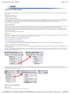
9 The units you would like the calculations to be in If the layer that is saved contains spatial information (PRJ file) then area/length will be calculated using that projection. If the layer does not contain spatial information the spatial reference of the active data frame will be used. EDITING WAYPOINT SHAPEFILE. ADDING STRIKE & DIP ATTRIBUTE FIELDS IN ARCMAP. 1. Right-click on the waypoint shapefile > Open Attribute Table. 2. Select the Options button > Add Field 3. In the Add Field dialog box enter Strike for the name and short integer for data type.
10 4. Select the Options button > Add Field 5. In the Add Field dialog box enter Dip for the name and short integer for data type. Editing Strike & Dip Attribute Fields in ArcMap 1. Open Editor Toolbar. Main menu > View > Toolbars > Editor. 2. From the drop-down menu on the Editor Toolbar select Start Editing > Highlight the data (folder) choice that contains the waypoint shapefile > OK. 3. Right-click on the waypoint shapefile > Open Attribute Table. 4. Enter Strike and Dip values in appropriate fields. 5. Stop Editing. From the drop-down menu on the Editor Toolbar select Stop Editing > choose to Save Edits.