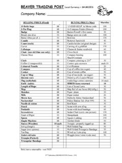
Transcription of ISLAND MAPS – AN INSTRUCTIVE GAME - …
1 A 15th Cheltenham (SHURDINGTON) Scout Group Resource - 2003 ISLAND MAPS AN INSTRUCTIVE GAME Use A4 sheet Landscape. Complete all Instructions below. Use Ordnance Survey symbols only - 1:50,000. Try not to use straight lines for roads. 9 Draw on the sheet an ISLAND to fill most of the page (an example above). 9 Put a COMPASS ROSE in a corner of the map as above. 9 In the centre of the ISLAND draw a LAKE. 9 From the lake draw a RIVER running south to the sea. 9 Where it meets the sea draw a CHURCH with a TOWER on the east bank. 9 On the far east of the ISLAND draw MIXED WOOD. 9 South of the wood draw a WINDMILL. 9 At the northeast point of the ISLAND draw a LIGHTHOUSE. 9 Next to the lighthouse draw a HELIPORT. 9 From the lighthouse draw an A ROAD to finish at the church.
2 9 At the west side of the ISLAND draw a CHURCH WITH NO TOWER next to a PUBLIC HOUSE. 9 From that church draw a PUBLIC FOOTPATH to the lighthouse, along the coast. 9 From the pub draw a B ROAD to the church with the tower, crossing the river by a BRIDGE. 9 Connect the windmill to the A road with B ROAD. 9 On the southwest side draw a QUARRY. 9 Connect the quarry to the lighthouse with a RAILWAY with STATIONS. 9 Run the RAILWAY from the quarry to the public house. 9 On the west side, slightly inland, draw a CAMPSITE. 9 From the lighthouse draw a BRIDLEPATH to the campsite via the lake. 9 By the church with a tower put in some HOUSES, a SCHOOL and a POST OFFICE. 9 Along the A road put in a TELEPHONE BOX. 9 Near the lighthouse put in a VIEWPOINT. 9 Draw a GOLF COURSE between the campsite and the lighthouse.
3 WELL DONE HAND SHEET IN WHEN