Transcription of Jumbo, Brewer and Doctor Creeks and Columbia Valley …
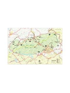
1 72 North Purcell MountainsJumbo, Brewer and Doctor Creeks and Columbia Valley Wetlands#14 JuMBo PASS Jumbo Pass is a gorgeous and increasingly popular alpine hiking destination. Karnak mountain and Jumbo Moun-tain tower in jagged steps north of the pass and they are the most prominent summits on the skyline. Commander Glacier and Glacier Dome cover the high country between Jumbo creek and Lake of the Hanging Glacier. Bastille mountain is a rugged, sculpted mass of rock rising south of the pass to 2606 m (8,555 ft.). Horseshoe Glacier alights with morning alpenglow west of the hiking trail is steep, but its varied scenery keeps the hike interesting. The hike starts in the dense, cool, moist forest, refreshing on a hot day. The forest floor is soft and quiet with the footfall of hikers boots cush-ioned on the carpet of needles.
2 The trail is an inviting ribbon for Pass after an early September snowstorm, with new snow and golden needles of the alpine larch : moderateTime: long day hike or two-day backpackDistance: kmElevation gain: 671 m (2,200 ft.)Jumbo Pass: 2280 m (7,500 ft.)Jumbo PassCabin: 2,300 m (7,710 ft.)Trail: steep with few switchbacks to high alpine pass; slightly braided in alpine; slick in wet weatherMaps: 82K/7 Duncan Lake (NAD83); 82K/8 Toby creek (NAD27)Trail map: page ####DriveRoad map: page ####Road: any vehicle, though a 2WD car may have trouble in wet weather. Most years the road is high drive from the highway to the trailhead is about two hours. Turn west from Highway 93/95 to Invermere. Turn right (north) at km, at the signed Panorama Ski Resort/Wilmer km: From Invermere drive north on the Panorama Ski Resort/Wilmer km: Turn left, west, to Panorama Drive, also called Toby creek km: Continue past the Panorama Ski km: Washed-out culvert may impede low-clearance PassAs the forest thins with rising elevation the views expand and the hike climbs through alpine meadows.
3 Mount Bastille s lower buttresses and towering peaks and glaciers surround you. Regal subalpine larch trees escort the hikers along the beautiful Pass CabinThe hut is managed jointly by the Columbia Valley Hut Society (CVhS) and the BC Forest Service. It is on an alpine ridge overlooking the spectacular view. The shelter sleeps eight and a tarn is nearby for summer drinking water. A BC Forest Renewal grant and the CVhS built the cabin in 1997, and according the society s website it replaced a 30-year-old structure that had seen its better days and was too small to meet the de-mands of an ever-growing interest of hikers and skiers to the see the beautiful vistas of Jumbo Pass. Camping is welcome at the ridge, and reservations are not required.
4 Please camp at least 100 m from the drinking-water tarn. Do not use firewood in summer, as it is expensive to fly in. The wood is for winter use only. Fires are not permitted in page #### for Columbia Valley Hut Society reservation and contact EventsThe widely known controversy over the Jumbo Glacier Alpine Resort and the BC government has been dron-ing on for almost 20 years. The disagreement is about permitting an extensive new resort at the headwaters of Jumbo creek . The area is only a half-dozen kilometres or so from the border of the protected wilderness of the Purcell Wilderness km: Take the right fork (north) at the signed Jumbo creek FS Road. (The left fork leads to Earl Grey Pass on Toby creek Road.) Stay on the Jumbo creek main road, parallel to the creek .
5 Several logging roads branch off; take the next two left km: Turn left at Jumbo Pass sign (past the 5 km sign), and cross Jumbo creek bridge to the south km: Cross the Leona creek bridge (14 km sign) and continue on the main road. Road bends and heads west beside Jumbo creek . Before the bridge is a large sandy km: Park beside the narrow road at the signed trailhead, at an old logging road junction on the left (south) (between the 15 km and 16 km signs).West Kootenay access to Jumbo Pass Glacier Creek0 km: At the junction of Highway 31, south of Cooper creek , turn nor th onto Duncan creek FS km: Turn right onto Glacier creek Road and follow it for 23 km: Take the right fork near a second bridge near the end of the km: Park at the trailhead on the left (east).The trail from Glacier creek is km and gains 700 m (2,300 ft.)
6 74 North Purcell MountainsTrail0 km: From the parking spot along Jumbo creek Road, hike up the old logging road left (west). The trail is well used and obvious. Almost immediately turn left again and hike up a steep trail. This is a new portion of trail that eliminates two tricky creek crossings. The trail ascends 61 m (200 ft.) steeply upward by the old km: Joins with the older trail in forest. After climbing 300 m (1,000 ft.) of elevation, you ll notice subalpine meadows becoming more prominent. The trail steepens, with a trickling creek on your right. When you get to the steep alpine creek , pay attention to an square orange marker nailed to a tree. It indicates a sharp right turn (west) and across the creek . Continue west toward a rockslide below the dark-grey cliffs of Bastille mountain .
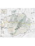
7 The trail crosses another tiny creek and begins to climb steeply in the grassy meadows. Flagging marks the km: Scenic alpine tarn at 2280 m (7,300 ft.). After a refreshing rest, continue to climb to the ridge at 2280 m (7,500 ft.). Other small lakes enhance the view and shimmer in the morning light, reflecting Horseshoe km: Hike along the wide ridge to the right (northwest) to Jumbo Pass and intersect with the trail coming from the West Kootenay Glacier creek trail. Keep heading northwest along the main trail on the km: Jumbo Pass cabin, N78870-E26694, is at 2,300 m (7,710 ft.) kmJumbo PassBastille MtnVolley MtnJumbo CreekGlacier CreekJumbo creek FSRG lacier creek FSRto Toby creek Rd JumboPass Cabinto Duncan LakeNorthern Purcells Jumbo Pass MapJumbo Pass Ma