Transcription of Kaiser Commerce Center Specific Plan
1 Kaiser Commerce Center Specific Plan San Bernardino County Economic Development and Public Service Group Land Use Services Department Adopted April 13, 1999 Revised January 4, 2007 Kaiser Commerce Center Specific PLAN ADOPTED MAY 13, 1999 TABLE OF CONTENTS REVISED JULY 3, 2003 i TABLE OF CONTENTS Page DIVISION 1. GENERAL PROVISIONS. 1-1 Chapter 1. Introduction. 1-1 Chapter 2. Existing Setting. 1-13 DIVISION 2. PROJECT COMPONENTS. 2-1 Chapter 1.
2 Land Use Plan. 2-1 Chapter 2. Public Services and Facilities. 2-51 Chapter 3. Circulation. 2-67 Chapter 4. Grading, Conservation and Open Space. 2-79 Chapter 5. Seismic Safety/Safety. 2-83 DIVISION 3. ADMINISTRATION. 3-1 Chapter 1. Administration. 3-1 Kaiser Commerce Center Specific PLAN ADOPTED MAY 13, 1999 TABLE OF CONTENTS REVISED JULY 3, 2003 ii LIST OF FIGURES Page - Regional Location 1-3 - Project Site 1-4 - Existing Water Facilities 1-26 - Existing Sewer Facilities 1-27 - Land Use Planning Areas 2-2 - Design Concept - On-Site Landscaping 2-20 - On-Site Landscaping 2-21 - On-Site Landscaping 2-22 - Tree Staking, Guying.
3 And Planting 2-23 - Industrial Landscaping 2-26 - Valley Boulevard (South Side) Landscaping 2-27 - Project Sign Location Plan 2-34 - Project Sign System Hierarchy 2-35 - Proposed Median Sign 2-36 - Proposed Water Facilities 2-53 - Proposed Sewer Facilities 2-55 - Proposed Drainage Plan 2-56 - Flood Hazard Areas 2-57 - Flood Hazard Areas (with LOMR) 2-58 - Dry Utilities 2-61 - Proposed Circulation 2-68 - Typical Roadway Section - Valley Boulevard 2-69 - Typical Roadway Sections Commerce Drive and San Bernardino Avenue 2-70 - Proposed Interchange and Roadway Improvements 2-73 - Conceptual Grading Plan 2-80 Kaiser Commerce Center Specific PLAN ADOPTED MAY 13, 1999 TABLE OF CONTENTS REVISED JULY 3.
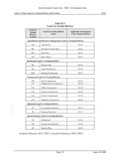
4 2003 iii LIST OF TABLES Page - Land Use Intensity 2-3 - Permitted Uses 2-4 - General Development Standards 2-15 - Kaiser Commerce Center Specific Plan Plant Palette 2-28 - Parking Standards for Industrial Buildings 2-30 - Sign Standards 2-39 - Stationary Source Noise Standards (in dB) 2-43 - Noise Standards for Exposure to Mobile Sources 2-45 - Estimated Water Demand 2-52 - Specific Plan Roadway Improvements 2-71 Kaiser Commerce Center Specific PLAN ADOPTED MAY 13, 1999 TABLE OF CONTENTS REVISED JULY 3.
5 2003 iv LIST OF ORDINANCES AMENDING THE DEVELOPMENT CODE Ordinance Date of Effective Number Adoption Date 3753 4-13-1999 5-13-1999 3807 11-14-2000 12-14-2000 3847 3-5-2002 4-4-2002 3891 6-3-2003 7-3-2003 3996 12-5-2006 1-4-2007 Kaiser Commerce Center Specific PLAN ADOPTED MAY 13, 1999 GENERAL PROVISIONS INTRODUCTION REVISED JULY 3, 2003 1-1 Division 1 GENERAL PROVISIONS Chapters: Page 1. Introduction 1-1 2. Existing Setting 1-13 Chapter 1 INTRODUCTION Sections: Page Specific Plan Area.
6 1-1 Purpose of the Specific Plan. 1-2 Project Objectives. 1-5 Authority. 1-6 Validity. 1-6 Plan Organization. 1-6 General Requirements. 1-8 Concurrent Discretionary Approvals. 1-9 Subsequent Discretionary Approvals. 1-10 Specific Plan Area. (a) Regional Location. The Kaiser Commerce Center Specific Plan is located on a portion of the site of the former Kaiser Fontana steel mill in the southwest portion of San Bernardino County, near the interchange of the San Bernardino (I-10) and Ontario (I-15) freeways (Figure ).
7 The approximately 468 acre project is centrally located within Southern California, approximately 40 miles east of downtown Los Angeles, 20 miles west of downtown San Bernardino, and 30 miles northeast of central Orange County. (b) Kaiser Commerce Center Specific Plan. The Kaiser Commerce Center Specific Plan site is located northeast of the San Bernardino Freeway/Etiwanda Avenue interchange. The project site is configured in an L shape (Figure ) that is generally bounded by the San Bernardino Freeway to the south and Etiwanda Avenue to the west.
8 The San Sevaine Flood Control Channel runs north-south along the eastern boundary of the site, north of San Bernardino Avenue and through the Center of the site s southern parcels. From San Bernardino Avenue, the eastern boundary of the project site continues south in an irregular manner to Valley Boulevard. Mulberry Avenue forms the eastern boundary of the project site south of Valley Boulevard. The northern boundary of the site is marked by Napa Street (west of the San Sevaine Channel), San Bernardino Avenue (east of the San Sevaine Channel to the eastern project boundary), and Valley Boulevard (to Mulberry Avenue).
9 Kaiser Commerce Center Specific PLAN ADOPTED MAY 13, 1999 GENERAL PROVISIONS INTRODUCTION REVISED JULY 3, 2003 1-2 The Kaiser Commerce Center Specific Plan site is within an unincorporated area with Fontana to the north, Ontario to the southwest, and Rancho Cucamonga to the north and west. The site is within the sphere of influence of the City of Fontana. Adopted Ordinance 3753 (1999); Amended Ordinance 3807 (2000); Amended Ordinance 3847 (2002); Amended Ordinance 3891 (2003) Purpose of the Specific Plan.
10 (a) Because the site is within unincorporated San Bernardino County territory, the Kaiser Commerce Center Specific Plan is being filed in accordance with the San Bernardino County Development Code. The project site is unique in that it encompasses a large tract of land under common ownership. It is located close to two intersecting interstate freeways, is served by nearby full freeway interchanges, and is surrounded by heavy industrial uses which are complementary to the uses proposed by this Specific Plan.