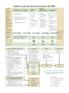
Transcription of KERN COUNTY GENERALIZED LAND USE ZONING GUIDE …
1 KERN COUNTY GENERALIZED land USE ZONING GUIDE ZONE TITLE TYPICAL USES MINIMUM PARCEL SIZE A Exclusive Agriculture Agricultural uses and other activities compatible with agricultural uses 20 acres; 80 acres if designated on General Plan and under Contract A-1 Limited Agriculture Combination of estate-type residential development, agricultural uses, and other compatible uses 2 1/2 acres E (1/4) Estate - 1/4 acre Larger-lot, single-family residential development; uses typical of and compatible with quiet residential neighborhoods 1/4 acre E (1/2) Estate - 1/2 acre Larger-lot, single-family residential development; uses typical of and compatible with quiet residential neighborhoods 1/2 acre E (1) Estate - 1 acre Larger-lot, single-family residential development; uses typical of and compatible with quiet residential neighborhoods 1 acre E (2 1/2) Estate - 2 1/2 acres Larger-lot, single-family residential development; uses typical of and compatible with quiet residential neighborhoods 2 1/2 acres E (5) Estate - 5 acres Larger-lot, single-family residential development; uses typical of and compatible with quiet residential neighborhoods 5 acres E (10) Estate - 10 acres Larger-lot, single-family residential development; uses typical of and compatible with quiet residential neighborhoods 10 acres E (20) Estate - 20 acres Larger-lot, single-family residential development.
2 Uses typical of and compatible with quiet residential neighborhoods 20 acres R-1 Low-density Residential Traditional smaller lot, single-family homes and compatible uses 6,000 square feet R-2 Medium-density Residential Single-family, duplex, and other medium-density, multifamily residential development; innovative housing techniques, including clustering and zero lot line development 6,000 square feet R-3 High-density Residential Medium- to high-density residential living environments, including apartments, townhouses, and condominiums 6,000 square feet MS Mobilehome Subdivision - 6,000 sq. ft. Mobilehome residential living environments restricted to final map subdivisions; uses typical of and compatible with residential neighborhoods 6,000 square feet MS (1/4) Mobilehome Subdivision - 1/4 acre Mobilehome residential living environments restricted to final map subdivisions; uses typical of and compatible with residential neighborhoods 1/4 acre MS (1/2) Mobilehome Subdivision - 1/2 acre Mobilehome residential living environments restricted to final map subdivisions; uses typical of and compatible with residential neighborhoods 1/2 acre MS (1) Mobilehome Subdivision - 1 acre Mobilehome residential living environments restricted to final map subdivisions.
3 Uses typical of and compatible with residential neighborhoods 1 acre MS (2 1/2) Mobilehome Subdivision - 2 1/2 acres Mobilehome residential living environments restricted to final map subdivisions; uses typical of and compatible with residential neighborhoods 2 1/2 acres MS (5) Mobilehome Subdivision - 5 acres Mobilehome residential living environments restricted to final map subdivisions; uses typical of and compatible with residential neighborhoods 5 acres MS (10) Mobilehome Subdivision - 10 acres Mobilehome residential living environments restricted to final map subdivisions; uses typical of and compatible with residential neighborhoods 10 acres MS (20) Mobilehome Subdivision - 20 acres Mobilehome residential living environments restricted to final map subdivisions; uses typical of and compatible with residential neighborhoods 20 acres MP Mobilehome Park Medium- to high-density mobilehome living areas; mobilehome parks with spaces; mobilehomes available for rent; accessory uses; recreation parks None CO Commercial Office Business and professional offices; low-intensity commercial activities 7,500 square feet C-1 Neighborhood Commercial Low-intensity commercial activities oriented to serving nearby residential areas; small retail, service-oriented commercial activities, including small shopping centers 7,500 square feet C-2 General Commercial Widest range of retail commercial activities, including regional shopping centers and heavy commercial uses 7,500 square feet CH Highway Commercial Uses and services normally associated with the traveling public, such as gas stations, restaurants, and motels.
4 Urban-type uses in rural areas adjacent to highways 7,500 square feet M-1 Light Industrial Wholesale commercial, storage, trucking, and assembly-type manufacturing, and other similar industrial uses; processing or fabrication limited to activities conducted within a building that does not emit fumes, odor, smoke, or gas beyond the confines of the building within which the activities occur or produce significant levels of noise or vibration None M-2 Medium Industrial General manufacturing, processing, and assembly activities None M-3 Heavy Industrial Heavy manufacturing, processing, and assembly activities None RF Recreational- Forestry Conservation and use of natural resources and compatible recreational uses 5 acres OS Open Space Preservation of identified scenic values, habitat for endangered plants or animals, unique geologic features, natural resources, passive recreational values None NR (5) Natural Resource - 5 acres Contain productive or potentially productive petroleum, mineral, or timber resources.
5 Resource exploration, production, and transportation, and compatible activities 5 acres NR (10) Natural Resource - 10 acres Contain productive or potentially productive petroleum, mineral, or timber resources; resource exploration, production, and transportation, and compatible activities 10 acres NR (20) Natural Resource - 20 acres Contain productive or potentially productive petroleum, mineral, or timber resources; resource exploration, production, and transportation, and compatible activities 20 acres DI Drilling Island Single lots and relatively small areas within final map subdivisions and mobilehome parks that contain productive or potentially productive petroleum resources; petroleum and gas exploration, production, and transportation; compatible open space and recreational uses 2 1/2 acres FPP Floodplain Primary Low-intensity uses not involving buildings, structures, and other activities that might adversely affect or be adversely affected by flow of water in the floodway None SP Special planning Encourage and facilitate the creative and innovative use of land which may otherwise be limited or prohibited by the standard provisions of other parts of the ZONING Ordinance 5 acres PL Platted Lands Residential uses and other compatible activities.
6 Future land divisions are prohibited Existing on April 15, 1982 LS Lot Size Combining Uses permitted by the base district with which it is combined Per requirements of base district PD Precise Development Combining Uses permitted by the base district with which it is combined Per requirements of base district CL Cluster Combining Innovative siting of buildings; uses permitted by the base district with which it is combined None RS Residential Suburban Combining Expand the number and type of permitted domestic agricultural uses within rural residential areas; allows one large animal for each 1/4 acre of lot area Per requirements of base district (lot of not less than 1/2 acre) MH Mobilehome Foundation Combining Installation of mobilehomes with or without foundations in agricultural, resource-related, and residential-zoned areas Per requirements of base district WE Wind Energy Combining Wind-driven electrical generators -- prototype and production; accessory administrative and maintenance structures and facilities; electrical substances, transmission lines, and other facilities and electrical structures accessory and incidental to main use; uses permitted by the base district with which it is combined Per requirements of base district (lot of not less than 20 acres) PE Petroleum Extraction Combining Wells for the exploration for and development and production of oil or gas or other hydrocarbon substances.
7 Deepening or redrilling, within existing well bore; drilling of a replacement well; uses permitted by the base district with which it was combined Per requirements of base district GH Geologic Hazard Combining To minimize property damage by designating areas subject to or potentially subject to surface faulting, ground shaking, ground failure, landslides, mudslides, or other geologic hazards; uses permitted by the base district with which it is combined Per requirements of base district FP Floodplain Combining Uses permitted by the base district with which it is combined Per requirements of base district (lot of not less than 20 acres) FPS Floodplain Secondary Combining Uses permitted by the base district with which it is combined (Certain measures are required to protect structures from a potential flood hazard) Per requirements of base district D Architectural Design Combining Uses permitted by the base district with which it is combined (Appearance of any structure is subject to review for compatibility with the established architectural motif) Per requirements of base district H Airport Approach Height Combining Uses permitted by the base district with which it is combined (Proximity to an airport limits height of structures to 35 feet)
8 Per requirements of base district For information pertaining to ZONING , please contact the following planning departments: (Contact the City planning Departments for ZONING information pertaining to incorporated properties, and contact the COUNTY planning Department for unincorporated area properties.) City of Arvin City of Maricopa City of Taft planning Department planning Department planning Division 200 Campus Drive 400 California 209 East Kern St. Arvin, CA 93203 Maricopa, CA 93252 Taft, CA 93268 (661) 854-2822 (661) 769-8279 (661) 763-3144 City of Bakersfield City of McFarland City of Tehachapi planning Department City Hall - planning Division City Hall - planning Department 1715 Chester Avenue P O Box 1488 115 S. Robinson Bakersfield, CA 93301 McFarland, CA 93250 Tehachapi, CA 93561 (661) 326-3733 (661) 792-3091 (661) 822-2200 City of California City City of Ridgecrest City of Wasco planning Department planning Department planning Department 2100 Hacienda Boulevard 100 West California Avenue PO Box 190 California City, CA 93504 Ridgecrest, CA 93555 Wasco, CA 93280-0190 (760) 373-7141 (760) 371-3721 (661) 758-7210 City of Delano City of Shafter COUNTY of Kern planning Department planning Department planning Department 1015 - 11th Avenue 336 Pacific Avenue 2700 M Street, Suite 100 Delano, CA 93215 Shafter, CA 93263 Bakersfield, CA 93301 (661) 721-3303 (661) 746-2065 (661) 862-8600