Transcription of KicKemuit RiveR tRail: WaRRen-BRistol loop - …
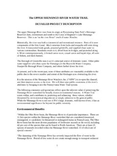
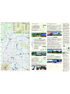
1 HUGH COLE RDCHILD STREET (ROUTE 103)METACOM DRIVEANNAWAMSCUTT DRIVEWARREN BIKE PATHASYLUM ROADBARKER RiverMt. Hope BayThe Meadows(PUBLIC)Hugh Cole s WellKee Farm(PRIVATE)LaurelParkTo uisset HighlandsTo uisset MarshWildlife RefugeAudubonMt. Hope Fishing AccessTo uisset PointBristolNarrowsMIDDLE AVENUE453621 LeveL IntermediateStart/end Mt. Hope Fishing Access, Annawamscutt Drive, Bristolriver MiLeS mile looptiMe 4 hours for loopdeScription Flat Water, Class IScenery Historic, wetlandsacceSS Possible portages at Barker Avenue and Harris Avenue for shorter trips and pickup (with very limited parking).GpS 41 41 N, 71 14 WKicKemuit RiveR trail : WaRRen-BRistol loopThe KicKemuit RiveR trail Bristol Loop is a great starting point for paddlers with more experience or with larger parties, as the Mt.
2 Hope Fishing Access1 accommodates up to 20 vehicles. The Mt. Hope Fishing Access , recently upgraded, offers a good access point for paddlers travelling north to the KicKemuit , or south around the tip of Mt. Hope. Mt. Hope (from the Wampanoag Montaup ) refers to the small hill in Bristol (about 209 feet) which drops sharply into Mt. Hope Bay. This hill was the actual seat of Metacom and the sight of the first battle of King Philip s War. The Fishing Access point is a launch for large and small boats, and this area of Mt. Hope Bay can be very busy in the summer high season, so paddlers should be aware of their surroundings. Access to the Warren Loop is found after entry at the Bristol Narrows to the north l2. Visible on both sides of the KicKemuit are Warren s summer cottage neighborhoods, Laurel Park l3 on the west and Touisset Point/Highlands l6 on the east.
3 In the late 1800s, travel became easier via train and summer homes sprouted along the KicKemuit RiveR . The construction of the Touisset Tennis Club in 1919 sparked construction even more of Touisset community. Now all of these neighborhoods have primarily converted to year round use. As you come to the narrow end of the RiveR , loop around and head back south. Across the RiveR south of Warren Bike Path is an 18 acre parcel of land called l4 The Meadows. Sensitive wetlands here surround a scenic field of upland (a great spot for picnics). Warren s Conservation Commission installed two osprey nests and the osprey pair nesting in The Meadows has successfully raised five broods. Warren s historic farms come into view just south. Warren has actively conserved such properties for decades, and now has over 700 acres in conserved lands (including over 500 acres of farmland).
4 The historic Kee Farm l5 , recently conserved, remains a private, active farm and cows can be seen along the water here. KicKemuit RiveR trail : WaRRen-BRistol MiLeS Map LeGend WAter ACCess l PoINts oF INterest WetlANDs n WAter WAter trail route np PArkINg roADs n CoNservAtIoN lANDKicKemuit RiveR the Warren loop, starting just south of route 103 offers a quiet paddle along 6 miles of conserved land and quaint shoreline residences. the longer Bristol-Warren loop offers sweeping views of Mt. Hope Bay and touisset Point before entering the southern entrance to the RiveR , known as the Bristol Narrows, and then integrating with the Warren loop. the KicKemuit RiveR is one of four rivers flowing into Mount Hope Bay, the northeastern corner of Narragansett Bay. the KicKemuit RiveR Council (krC) is an all volunteer, non- profit 501(c)(3) representative organization founded in 1973, dedicated to preservation, protection, and improvement of the RiveR .
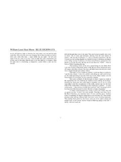
5 Narragansett Bay estuary Program (NBeP) protects and preserves Narragansett Bay and its watershed through partnerships that conserve and restore natural resources, enhance water quality and promote community involvement. NBeP supports the rI Blueways Alliance which is dedicated to creating a comprehensive water trail network to link rhode Island s rivers, lakes and ponds to Narragansett Bay and to the rivers in Massachsuetts that flow into the bay. the trail will be used to promote safety, conservation, recreation and economic development. RiveR in HistoRyWampanoag people named this RiveR KicKemuit , which is thought to mean at the large spring. The towns of Warren and Bristol now occupy the original site of the Pokanoket village Montaup , which formed part of the Wampanoag Confederacy led by the Massassoit (Great Sachem) Ousamequin.
6 The Wampanoag began trading with Englishmen from Plimoth Colony when a post was established on the western bank of the KicKemuit in 1632. The English settlers eventually bought land along the KicKemuit from the Wampanoag in 1653, but the relationship between the Wampanoag tribe and the English settlers was always uneasy. Ousamequin s son Metacom (also known as King Philip) inherited the role of Sachem in 1662. Metacom opposed the imposition of the ever-expanding English colonies, the spread of illnesses brought by settlers, constant threats, legal disputes and the exploitation of natural resources. In 1675, war between the Wampanoags and the English (known as King Philip s War ) began at the KicKemuit RiveR . With the end of King Philip s War in 1677, English settlers once again returned to the RiveR and evidence of this new settlement can be seen on the eastern edge with Hugh Cole s Well.
7 A century later, as the towns of Warren and Bristol fought in the American Revolution, the row galley Washington was sent to protect the entrance to the KicKemuit RiveR near the Bristol Narrows. In 1777, an explosion on the galley killed eight men. The bodies of the victims of this accident were buried on the western shore of KicKemuit RiveR near the narrows of the stream, not far from the scene of the disaster. ecology of tHe KicKemuit RiveRKickemuit RiveR is one of the smaller tributaries to Narragansett Bay. The RiveR is relatively shallow, ranging from 5 feet to the north and along the shore to a depth of about 16 feet in the lower interior sections. As a tidal RiveR , crabs and schools of fish are visible along the Barker Avenue portage. The RiveR is generally open for shellfish harvesting. Blueback herring, alewives and American shad utilize the RiveR for spawning and nursery grounds, while Atlantic Menhaden and Silversides migrate here in the summer.
8 The northern portion of the KicKemuit RiveR is an important migratory area for stopover and over-wintering bird species. Osprey are flourishing and various owl species have been seen. The fields on the eastern shores offer an ideal bird habitat, providing both cover in the hedgerow borders and foraging in open fields. The variety of habitats agricultural fields, forest, open water, freshwater and saltwater support deer, fox, raccoon, opossum, coyote, woodchuck, and birds such as eastern meadow lark, sparrows, red-tailed hawk, ring-necked pheasant, killdeer, woodpeckers, orchard oriole, cardinal, owls and many others. DiRectionsFrom route 136 (Metacom Avenue) turn east onto Annawamscutt Drive. In about miles look for a road on the right leading to the access site. If you come to the end of Annawamscutt Drive you have gone to far.
9 There is access to the shore at the end of Annawamscutt Drive but it is not as convenient as at the boat organizations throughout the Narragansett Bay watershed showcase paddling opportunities on downloadable paddle maps. the full list of maps is available at wear your Life jacket and carry a whiStLe or other Sound producinG device, preferabLy attached to your Life jacket. paddLerS ShouLd check water LeveL and tideS, weather, and waterway conditionS prior to every trip. reMove what you brinG, cLean up More if you can. pLeaSe reSpect private property. report any probLeMS you encounter to the KicKemuit RiveR counciL and LocaL authoritieS if appropriate.