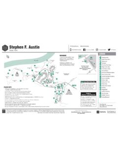
Transcription of Lost Maples State Natural Area Facility Map
1 SteepSteepSteepCanCreekLaneCreekSabinal River Sabinal River RM18 72,200 Elevation2,075 ElevationSpringSteepPark BoundaryService RoadPark B oundaryEast Tr ailEast Tr ailEast Tr ailFLASH FLOODS are common in thisarea. In case of heavy rain, move tohigher ground and DO NOT crossswollen Tr ailSpringPark BoundaryWest Tr ailPark BoundaryHale Hollow Creek Private property outside park boundary - No TrespassingPark BoundaryWest Loop Trail PondsMystic Canyon West Trail West Trail East Trail maple Trail SteepSteepDEFGH2091021123304567811121314 15161718192229282725242326 Park closes at 10 to overnight IT SAFE. Portions of hiking trails are steep and rugged. Ta ke plenty of water and please consider your physical ability, trail and weather conditions before hiking. CONSULT PARK PERSONNEL FOR ADVICE ON TRAIL NOTETRAIL & PRIMITIVE CAMP USE WALK ON DESIGNATED TRAILS ONLY.
2 Do not climb on cliffs or hillsides. Camp in designated areas only A through H. FIRES PROHIBITED IN THE BACK COUNTRY. Cook only with contained fuel stoves. Pack out what you pack in. Keep noise to a minimum. Park quiet hours are 10 to 6 Pets allowed on leash Maples State Natural AreaLEGENDP roud Sponsor ofTe xas State Parks 2022 TPWD PWD MP P4507-074B (2/22) This publication can be found at receives funds from the USFWS. TPWD prohibits discrimination on the basis of race, color, religion, national origin, disability, age, and gender, pursuant to State and federal law. To request an accommodation or obtain information in an alternative format, please contact TPWD on a Text Telephone (TTY) at (512) 389-8915 or by Relay Texas at 7-1-1 or (800) 735-2989 or by email at If you believe you have been discriminated against by TPWD, please contact TPWD, 4200 Smith School Road, Austin, TX 78744, or the Fish and Wildlife Service, Office for Diversity and Workforce Management, 5275 Leesburg Pike, Falls Church, VA (512) 389-8900 PARK RESERVATIONS HeadquartersRestroomsShowersComposting ToiletPrimitive Camping SitesWater and Electric SitesDump StationHiking Tr ailPicnic AreaParkingScenic OverlookInterpretive CenterBird Viewing BlindWheelchair AccessibleResidenceMaintenance37221 187 Vanderpool, TX 78885(830) 966-3413 maple Tr ail.
3 8 Tr ail Tr ail Loop Tr ail Trails (Round-trip)#TxStateParks #BetterOutsideTe assistance using this map, contact the park.