Transcription of Louisiana Citizen Awareness & Disaster Evacuation …
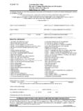
1 Louisiana Citizen Awareness & Disaster Evacuation GuideSOUTHWESTRev. 3/09 Phased EvacuationDuring a threat of a hurricane, a phased Evacuation will be based on geographic location and time in which tropical storm winds are forecasted to reach the affected areas. Phase I - 50 Hours before onset of tropical storm winds. Includes areas south of the Intracoastal Waterway. These areas are outside any levee protection system and are vulnerable to Category 1 and 2 storms. These areas are depicted in RED on the Evacuation Map. During Phase I, there are no route restrictions. Phase II - 40 Hours before onset of tropical storm winds. Includes areas south of the Mississippi River which are levee protected but remain vulnerable to Category 2 or higher storms. These areas are depicted in ORANGE on the Evacuation Map. During Phase II, there are no route restrictions.
2 Phase III - 30 Hours before onset of tropical storm winds. Includes areas on the East Bank of the Mississippi River in the New Orleans Metropolitan Area which are within levee protection system but remain vulnerable to a slow-moving Category 3 or any Category 4 or 5 storm. These areas are depicted in YELLOW on the Evacuation Map. During Phase III, certain routes will be directed and the Contraflow Plan Evacuation procedures are for traffic management purposes only. Consult your local Office of Emergency Preparedness Director for further Evacuation can occur anywhere at anytime, and at a moment s notice citizens may need to move quickly out of harm s way. Government agencies have planned and are prepared for possible emergencies that might arise. It is important that you and your family have a plan as guide will assist you and your family with creating such a plan.
3 I encourage you to study this guide, so that you can be best prepared to evacuate safely and efficiently from impending threats should the need occur. In the event of an emergency, you should stay alert and pay attention to the news and announcements in your area so if a situation develops, you are immediately informed. For more information, please visit the Governor s Office of Homeland Security and Emergency Preparedness at or ,Bobby JindalGovernorFAMILY COMMuNICATIONs PLANS etting up a family communications plan ahead of time will help make sure you and your family can connect as easily and quickly as possible. Designate an individual outside of the state to serve as a family point of contact. (After a Disaster , it s often easier to call out-of-state than within the affected area.)
4 Make sure that all family members know who this person is and how to contact him/her. After a Disaster or Evacuation , all family members should make contact with the designated individual. Try choosing a certain time for everyone to check FAMILY Evacuation PLANP ersonal responsibility is the key to safety during a Disaster . Ensure your family has a smart and often-practiced plan!American Red 1-800-RED-CROSS or 1-800-733-2767 Espa ol 1-800-257-7575 Acadiana Chapter (Lafayette) (337) 234-7371 Central Louisiana Chapter (Alexandria) (318) 442-6621 Louisiana Capital Area Chapter (Baton Rouge) (225) 291-4533 Northeast Louisiana Chapter (Monroe) (318) 323-5141 Northwest Louisiana Chapter (Shreveport) (318) 865-9545 Southeast Louisiana Chapter (Greater New Orleans) (504) 620-3105 Southwest Louisiana Chapter (Lake Charles) (337) 478-5122 St.
5 Bernard Chapter (St. Bernard Parish only) (504) 277-8163 Louisiana Department of Transportation and Development Customer Service Center (225) 379-1232 toll-free (877) 4 LADOTD or (877) 452-3683 Governor s Office of Homeland Security and Emergency (225) 925-7500 Louisiana Department of Social Department of Health and State Road Closure Information (800) 469-4828 Troop A (Baton Rouge) (800) 969-2059 Troop B (Kenner) (800) 964-8076 Troop C (Gray) (800) 659-5907 Troop D (Lake Charles) (888) 225-5577 Troop E (Alexandria) (800) 256-4160 Troop F (Monroe) (866) 292-8320 Troop G (Bossier City) (866) 853-6580 Troop I (Lafayette) (888) 768-8746 Troop L (Covington) (888) 339-8659 or dial *LSP (*577) from a cellular phoneLouisiana Attorney Fair Housing Hotline (800) 273-5718 Investigations (800) 488-2770 Consumer Hotline (888) Department of Agriculture and Forestry Department of Homeland Weather CONTACT INFORMATION Strengthen your home against future storms.
6 Visit SurE* NatioNal iN stitute of BuildiNg scieNcesrEInforcEfor every dollar spent on mitigation, approximately four dollars are saved in reduced losses.*sponsored 19/26/08 8:00:06 AMLet s Mitigate LouisianaEvacuation Area of the stateRe-entry from Mississippi on 65 & 84Re-entry from Mississippi on I-20 From Southeast area on La. 1 From Southeast/Central area on I-49 From Southeast/Central areas on 71 From Southeast/Southwest/Central areas on 171 & I-49 From Southwest on 171 From Southwest/Central areas on 165 From Southeast area on La. 1 Information Point LocationTourist Welcome Center Tourist Welcome CenterParagon CasinoSammy s Truck StopMed Express GymLSU-ShreveportPickering High SchoolTourist Information CenterMaddie s Truck 165 & 84 1401 Carter StreetVidalia, LA836 I-20 WestTallulah, LAParagon PlaceMarksville, LAI-49, Exit 533601 LA 115 WBunkie, LA7525 71 Alexandria, LAOne University PlaceShreveport, LA 180 Lebleu Rd.
7 Leesville, LA8904 165 Oberlin, LA 15972 La. 1 Simmesport, LAEMERGENCY sHELTER INFORMATION POINTs WHAT TO DODURING A CHEMICAL OR BIO-HAZARD RELEASE IF YOU MUST BE Protect your breathing by covering your mouth and nose with a cloth or YOU ARE IN YOURVEHICLE AND CAN T GET TO A SAFE Pull over to the side of the road. 2. Turn the engine off and close the windows and vents. 3. Listen to the radio regularly for updated advice, instructions and conditions. PuBLIC sHELTER INFORMATIONS helters are operated by trained individuals and ensure that the safety. security, and basic needs of its residents are to bring to a shelter? Change of clothing, blanket, and pillow for each family member Your Disaster supply kit, including food, medications, comfort items, and special items for infant or elderly family NOT to bring?
8 There are no weapons, drugs or alcohol allowedRADIO FREQuENCY sYsTEM Louisiana Emergency Alert system The following radio stations are key participants in the Louisiana Emergency Alert System. In the event of an emergency, these stations will broadcast emergency WEATHER TERMs TO disasters most likely to occur in Louisiana , particularly inlow-lying areas bordering the Gulf of Mexico, include hurricanes andflooding due to heavy rains. Residents should be familiar with severalterms that describe severe weather conditions:MEAsuRING HuRRICANE sTRENGTHThe Saffir-Simpson Hurricane Scale NOAA Weather Radio (NWR) NOAA Weather Radio is a nationwide network of radio stations broadcasting continuous weather information direct from a nearby National Weather Service office. NWR broadcasts National Weather Service warnings, watches, forecasts and other hazardous information 24 hours a IN-PLACE INFORMATION Sheltering in place is a precaution aimed at keeping citizenssafe while remaining indoors.
9 This is not the same thing asevacuating to a shelter and not recommended for a shelter-in-place order is given by either local or stategovernment, citizens within the affected area should take thefollowing protective measures: Go indoors and close all windows and doors. Turn off all sources of outside air ( air conditioners and ventilation fans/ducts). Remain indoors until notified that it is safe to move outdoors. Stay tuned to your local radio/television station to receive official notices. Limit telephone usage to emergency calls only. This is to prevent the telephone lines from being overloaded with non-emergency Homeland Security Advisory System,established in March of 2002, is a tool usedto describe threat conditions for a possibleterrorist attack. A color-coded threat levelsystem is used to communicate the fivethreat levels to the American your family for these types ofemergencies by following therecommendations in this guide or For more information onHomeland Security advisories, visit theGovernor s Office of Homeland Securityand Emergency Preparedness 970 (KSYL)AM 580/FM (KZMZ)FM (KQID)Baton RougeAM1150 (WJBO)FM (WFMF)CrowleyFM (KAJN)LafayetteFM (KTDY)Lake CharlesAM 1470 (KLCL)FM (KHLA)New OrleansAM 870 (WWL)FM (WLMG)NortheastAM 540/FM (KNOE)RustonAM 1490 (KRUS)FM (KXKZ)ShreveportAM 1130/FM (KWKH)storm surge: An abnormal rise of the sea along a shore as the result,primarily, of the winds from a : Adverse conditions are possible in the specified areas of the WATCH, usually within 36 hours.
10 May be applied to thunderstorms, tornadoes, floods, or : Adverse conditions are expected in the specified areaof the WARNING, usually within 24 hours. May be applied tothunderstorms, tornadoes, floods, or 1: Minimal Damage. Winds 74-95 mph. Storm surge generally 4-5 ft. above 2: Moderate Damage. Winds 96-110 mph. Storm surge generally 6-8 ft. above 3: Extensive Damage. Winds 111-130 mph. Storm surge generally 9-12 ft. above normal. 4: Extreme Damage. Winds 131-155 mph. Storm surge generally 13-18 ft. above normal. 5: Catastrophic Damage. Winds greater than 155 mph. Storm surge generally greater than 18 ft. above YOUR ANIMALS Making plans for your family is extremely important. Don t forget to plan for the animals in your life, too! The location of your Evacuation destination may or may not accept pets, so call ahead and check.