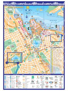
Transcription of Lysefjord Map - Norway - Stavanger
1 E 39131345454550750850346844509510 TURISTVEGRYFYLKEM nafossenStoravatnetLyngsvatnetValevatnLy sefjordenKvits yTungenesHolmst lvatnet rsdalslvatnetOltedalsvatnetOrrevatnetS R-HIDLEHUNNEDALENSIRDALENSULESKARVEGENS A N D N E SForsandLandaOanesLauvvik vre EspedalByrkjedal dneramFidjelandLysebotnNilsebuSinnes vre irdalSStavtj rnFrafjordBueN rb H BryneSola lg rdBrekkoOltedalFiggjoGloppedalsuraJ rpelandHommers kSIRDALJ RENJ RMUS ETBYRKJEDALSTUNETV assleiaK senSongesandFyljesdalenTa uUtsteinKlosterKvits yROGALANDVEST-AGDERL ysefjord-enteretsTonstadByrkjelandsvatne tS T A V A N G E RRYFYLKENORTH SEA ROADSTAVANGERAIRPORT1000m(3281ft.)KJERAG 60 m4(19ft.)82 PREIKESTOLEN(Pulpit Rock)PreikestolenFjellstuekm1020500510 MilesNBOAT TRIPS - R DNEPRIMARY ROUTEBOUNDARY with SCENIC VIEWL ysefjord mapSTAVANGER - LYSEFJORDFERRY7 Edition - R DNE FJORD CRUISEthDate of Issue: 11th November 20 51 Norsk/EnglishPREIKESTOLENO N B O A R DFANTAH L GEITENEPREIKESTOLENP ulpit Rock(1000m - 3281ft)(604m - 1982ft) Stavanger DN YBERGSHOLMENLYSEBOTN YGARDST LLYSEBOTNKRAFTVERKLYSEFJORD-SENTERETHELL ERENJETTEGRYTENFORSANDHOMMERS KLAUVIKJ RPELANDEIANETINGHOLMENTAUKALLELISTEINKOB BERVERDENS LENGSTETRETRAPPER?
2 FL YRLIKRAFTVERKBRATTELIHENGJANENIBB HENGJANEFOSSENBAKKEN G RDH HELLERKJERAGSONGESANDOANESLYSEFJORDENH GSFJORDENLYSEFJORDENKMLOPRSTUVWXYQNABCDE FGHIJkm105005 MilesLOCATION5 9 0 ' 0 ' ' N , 6 1 9 ' 0 ' ' EN O R WAYTEGNFORKLARING/LEGEND:B TRUTE/BOAT ROUTEUTSIKT/VIEWPOINTL YPA/TREK PREIKESTOLEN BUSSRUTER/BUS ROUTEPREIKESTOLHYTTASEVERDIGHETER/SIGHTS Stavanger - LYSEFJORDABCWELCOME ON BOARDWELCOME ON BOARDABCDEFGHKMLOPRSTUVWXYQNIJand the crew welcome you on board! The trip will take us far into the country and show us idyllicisland scenery as well as a wild and beautiful West Norwegian nature. In order to be prepared in case of an emergency,we ask you to please read the safety information on is today the fourth largest city in Norway with approximately inhabitants.
3 Stavanger isconsidered to be the oil capital of Norway , but before oil was discovered in the North Sea it was fish, specificallysardines that kept the city passing the historically interesting Tingholmen, where King Olav Tryggvason heldhis national assembly in 998, we proceed into the H gsfjord. Many Stavanger families have their summerhouses alongthe coastline Lysefjord is 42 km long. The name dates back to the old Norse name L sir or light. It is believed thisrefers to the lightly colored granite that can be found in the fjord. The Lysefjord was formed by glaciers during the iceages. During the most recent ice age, about years ago, Norway was covered with a layer ofice that was up meters thick.
4 The fjord is a deep ravine between mountainous valley sides. Between Oanes and Forsand, thereis an end moraine of sand, and the fjord is only 10-20 meters deep at this point. Ever since man first settled in the area,fishing and hunting have been important activities here. Even today, people fish for brisling throughout the summer has a ferry link to Lauvvik. The road from Oanes leads to J rpeland andthen continues into the region of Ryfylke. The Ryfylke Route is popular with tourists and offers a wealth of beautifulsights and places to visit. The Lysefjord Centre is located at Oanes. The centre provides tourist information about theLysefjord and is the municipal centre of Forsand municipality, and has approximately inhabitants.
5 Nearby,at Forsandmoen, a whole prehistoric village was discovered and excavated. This village was a permanent settlementfrom about year BC to 600 AD.(pothole) Here is a big pothole which is shaped by a stone that got into the flow of water that eruptedwhen the ice melted, and thus have made the hole bigger and bigger. It is said that it was here that people from furtherup the fjord came to bathe before going to church on Fjord Restaurant - an idyllic restaurant with a unique location in theLysefjord. Open all year. Helleren has an impressive location at the foot of a high cliff, and is popular with tourists andother groups. A perfect choice for company outings, meetings and conferences or any other special occasion.
6 Greatfood and extraordinary surroundings!Eiane is a small settlement of three farms at vre ( upper ) Eiane, and one farm at Nedre ( lower ) Eiane. Upuntil 1959, Eiane was famous for its stonemasonry. The cobblestones that we walk on in the city center of Stavangercome from l ( vagabond s cave ) is a small mountain cave named after a group of vagabonds who soughtshelter there on the run from the local goats at the foot of the Pulpit Rock are a popular tourist attraction. These goats are put out to graze duringthe summer months, and they have become rather spoiled with food from boats that stop by and feed , also known by the English translation Pulpit Rock, is one of the most famous touristattractions in Norway .
7 The top of the cliff is approx. 25 by 25 meters (82 by 82 feet) square and almost flat, and the cliffis 604 meters above the fjord. The view from the top is extraordinary. The rock formation was formed during the last iceage, approx. 10 000 years ago. The edge of the glacier was then just above the the spectacle of this lovely waterfall where pure, fresh mountain water plummets400 meters down into the hikers think this mountain is far more exciting to climb than the Pulpit Rock. The HengjaneGerman a deserter from World War I lived on the Hengjane farm, which unfortunately is just a ruin today. Here hegot involved in various illegal activities, including the distilling of the old days, Bratteli was a lovely little settlement with four farms.
8 But the last inhabitants moved away farm is located in the hills 170 meters above the Lysefjord and is now in use for was linked to the outside world by road for the first time in 1994. Today a handful of familieslive in this are many seals in the fjord. The native population is around buildings on this farm illustrate very well how houses were built in old times in the Lysefjord long andnarrow perhaps just to seem more impressive from the is the oldest power station in the Lysefjord area built in 1917 and modernizedin1938. The new power station at Fl rli, which opened in 1999, is situated about 800 meters into the mountain. The oldstation is presently being used for art exhibitions and other cultural the pipelines is perhaps the longest woodenstaircase in the world with its 4 444 heller was the largest and richest farm in the whole Lysefjord area.
9 The first inhabitants settled here inthe 1580s, but today the farm is can barely see The Bolt (a wedge-shaped boulder) wedged inthe crack between tw omountains almost 1 000 meters above the fjord. Hiking to Kjerag has become almost as popularas hiking to the Pulpit Rock, and the view from the top is quite amazing. It takes about 2 hours to walk from ygardst lto the top of first section of this power station was put into operation in 1953. It is the largestpower station in the Lysefjord village here is a modern community whose livelihood is based on the power production. The majorityof the people here are connected with the power company Lyse Kraft. Lysebotn is also where the newest and mosttechnologically advanced power station is located Tjodan Power Station built 1 kilometer inside the mountain andopened in 1985.
10 Ther oad connection over the mountains from Lysebotn is open only during summer. In winter, the onlyway to reach Lysebotn is by car-ferry/express boat. ygardst l (also known as The Eagle s Nest ) is a modern tourist centre perched up in the mountains640 meters above Lysebotn. It has a restaurant, tourist information, a shop and of course a magnificent view of theLysefjord and Lysebotn. R dne Fjord Cruise would like to thank you for joining us and look forward to seeing youR dne Fjord CruiseSTAVANGERTINGHOLMEN/H GSFJORDLYSEFJORDOANES - THE Lysefjord CENTREFORSANDJETTEGRYTENHELLEREN FJORD RESTAURANTEIANEFANTAH L GOATSPULPIT ROCKTHE HENGJANE WATERFALLONWARDS TO LYSEBOTN:HENGJANE NIBB BRATTELIBAKKEN FARMSONGESANDSEALS - STEINKOBBER (Phoca vitulina)KALLELIFL RLI POWER STATIONTHE LONGEST WOODEN STAIRCASE IN THE WORLD?