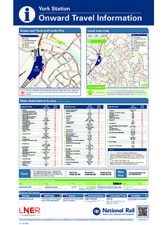
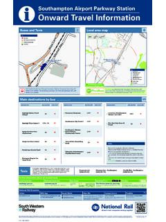
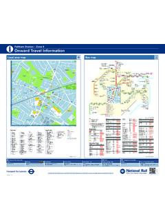
Transcription of Mill Hill Broadway Station – Zone 4 Onward Travel …
1 CI OTI MIL V8 0117 Onward Travel InformationiMill hill Broadway Station Zone 4 Local Area MapBus MapEdgwareCommunityHospitalKentonLibrary QueensburyLawrence StreetSunny eldLawrence StreetThe ReddingsHighwood HillHolcombe HillHighwood HillMill hill /Rising SunTotteridgeCommonHendon Wood LaneTotteridge VillageWar MemorialTotteridge &WhetstoneWhetstoneGrif nBrunswick ParkOakleigh Road SouthArnos GroveDaws LaneBirkbeck RoadHammers LaneWise LaneHammers LaneShakespeare RoadThe RidgewayMill hill /Three HammersThe RidgewayMill hill SchoolThe RidgewaySt. Vincent s SchoolThe RidgewayMedical Research InstituteThe RidgewayEngel ParkMill hill EastHoldersHill RoadHendonQuadrantHendonBell LaneGolders Green RoadNorth Circular RoadGolders GreenFlower LaneParkmead GardensBunns Lane BridgeBunns LaneCopthallGardens/Page StreetPursley RoadPage StreetPursley RoadCopthall Sports CentrePursley RoadSalcombeGardensEngel ParkRushdeneGardensEngel ParkBittacy HillLullington GarthNorth FinchleyTally Ho CornerFriern BarnetTown HallNew SouthgateBounds GreenWood GreenWood GreenShopping CityTurnpike LaneWatford WayMill hill ParkWatford WayTithe WalkWatford WayFive Ways CornerWatford WayWestsideWatford WaySouth eldsWatford WayGreyhound HillHendonWar MemorialHendon CentralHendon WayFinchley Road & Frognal Finchley
2 RoadSwiss CottageSt. John s WoodLord s Cricket GroundPark RoadBaker Streetfor Madame Tussaud sMarble ArchBunns LaneWoodcroft AvenueCorner MeadWiggins MeadBarnet CollegeCorner MeadSouth MeadRoyal Air Force MuseumLanacre AvenueCherry CloseQuakers CourseColindaleColindaleAvenueAjax AvenueAnnesleyAvenueEdgware RoadThe GreenwayColindaleASDAB rent CrossShopping CentreApex CornerEdgware WayOakmead GardensEdgware WayStony elds LaneEdgware WayHighview AvenueEdgwarebury LaneEdgware WayEdgwarebury LaneEdgwarebury GardensEdgwareHale LaneBeech WalkHale LaneDownhurst AvenueHale LaneCloister GardensHale LaneFarm RoadHale LaneBroad elds AvenueHale LaneThe DriveEdgwareStation RoadEdgwarePolice StationCanonsParkBelmont CircleHarrow & WealdstoneHarrow Bus StationHarrow-on-the-HillPorlock AvenueSouth HarrowEastcote LaneSouth RuislipRuislip ManorRuislipLyndhurstAvenue edgware WayBroad elds AvenueEdgware WayThe GroveEdgware High StreetSpring Villa RoadEdgware High StreetDeansbrook RoadDeansbrook RoadBlood Transfusion CentreDeansbrook RoadGrange RoadDeansbrook RoadEdwin RoadDeansbrook RoadDeans LaneDeansbrook RoadDeansbrook CloseOrange hill RoadRuddock CloseOrange hill RoadNorwich WalkBurnt OakEvers eld GardensWatling AvenueGoldbeaters GroveWatlingAvenueBurnt OakLeisure CentreWatling AvenueGunter GroveBurnt Oak BroadwayHighlandsStag LaneCarlisle RoadStag LaneGrove ParkRoe GreenFair elds CrescentKingsbury GreenKingsburyBlackbird CrossNeasden Shopping CentreDudden hill LaneWillesden Bus
3 GarageWillesden Green LibraryChamberlayne RoadKensal RiseKenton Northwick Parkand St. Mark sHospitals Stag LaneOak GardensStag LaneHolyrood GardensMollison WayBittacy HillSanders LaneTotteridgeCommonWest End HouseTotteridge CommonEllern MedeTotteridgeCommonSt Edwards CollegeField MeadGrahame Park WayBeaufort ParkOrange hill RoadPark CroftFinchley RoadO2 CentreBrent CrossNorth Circular RoadMontrose AvenueCressingham RoadLanacre AvenuePageant AvenueLanacre AvenueNorth AcreAerodrome RoadHeritage AvenueAerodrome RoadPeel CentreAerodrome RoadRowan DriveBurnt Oak BroadwayNorth RoadOxford CircusPiccadilly CircusTrafalgar Squarefor Charing Cross 114 186303302113186240251221240251113221303N 113 N113 The yellow tinted area includes every bus stop up to about one-and-a-half miles from Mill hill Broadway .
4 Main stops are shown in the white area HillCircusMill HillBroadwayHARTLEY AVENUETHE BROADWAYVICTORIA WAYDAWS LANEWATFORD WAYLAWRENCE MOTORWAY (ELEVATED)HALE LANEBUNNS LANEFLOWER LANEGOODWYN AVENUEMILLWAYRHBACDFKPQMSTU P1ndarRUISLIPEDGWAREHARROWWOODGREENGOLDE RS GREENHENDONSWISS COTTAGECENTRAL LONDONWILLESDENKENTONBRENT CROSSD estination Bus routes Bus stopsAAerodrome Road 186 +B +H+H +SAnnesley Avenue 303 +B Apex Corner 113.
5 N113 +P +R 186 +F +M +RArnos GroveO 251 +F +M +TBBaker StreetO for Madame Tussaud s 113, N113 +Q +S Barnet College 303 +B Belmont Circle 186 +F +M +RBittacy hill 221 +F +K 240 +F
6 +M Bounds GreenO 221 +F +K Brent Cross North Circular Road 113, N113 +Q +S 186 +B +H+H +SBrent Cross Shopping Centre 186 +B +H+H +SBrunswick Park 251 +F +M +TBunns Lane
7 Copthall Gardens 221 +F +K Bunns Lane Woodcroft Avenue 303 +B Bunns Lane Bridge 113, N113 +Q +S 221 +F +K Burnt OakO 114 +B 251 +A +H +U 302 +C Burnt Oak Broadway
8 251 +A +H +UCCanons ParkO 186 +F +M +RChamberlayne Road 302 +C Colindale O and ASDA 303 +B Colindale Avenue Ajax Avenue 303 +B Corner Mead 303 +B DDaws Lane 240 +F +M Deansbrook Road 302 +C 303 +D Dudden hill Lane 302
9 +C EEastcote Lane 114 +B edgware O 113, N113 +P +R 186 +F +M +R 221, 240 +D +H 251 +A +H +U 303 +D edgware Police Station 186 +F +M +REdgware Station Road 186 +F +M
10 +R 251 +A +H +U 303 +D Edgwarebury Lane