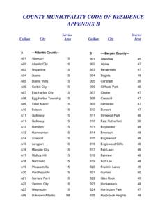
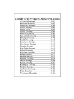
Transcription of Municipal, county and state boundaries data available for ...
1 municipal , county and state boundaries data available for New jersey Posted: July 20, 2016 municipal , county and state boundaries data are available from NJGIN. The data sets are available to the public on the NJGIN Data Download site in ESRI File Geodatabase format and ArcView Shapefile format. Updates July 20, 2016 Modifications were made to the municipal boundaries of the following towns in Monmouth county , as a result of the incorporation of municipal parcels (Asbury Park, Bradley beach Borough, and Neptune Township) based on digital tax maps into the statewide parcel composite: Asbury Park Avon-by-the-Sea Borough Bradley Beach Township Neptune City Neptune Township Tinton Falls Borough Wall Township The nj_state (polygon of the entire state of NJ) was added to the topology feature class for the municipal , county , and state boundaries to keep the coincident municipal and county features in line with the state boundary and contain all of the municipal and county features within the state of NJ feature.
2 November 2, 2015 Modifications were made to the Essex county municipalities and the Essex, Union, and Passaic county boundaries as a result of the Essex county comprehensive edge matching process. A modification was made to the municipal and county boundaries for Millburn Township, Essex county and Chatham Borough, Morris county to restore the boundaries to the former Passaic River alignment. The Passaic River was re-aligned many years ago as part of state Highway 24 construction. Since the river re-alignment was due to human activities rather than natural processes, the boundaries still follow the previous alignment of the river. Tax maps from both towns, the Morris county parcels for Chatham Borough, and 2012 orthophotos were used as sources. Modifications were made to the municipal and county boundaries along Green Brook to restore the boundaries to the former alignment of Green Brook.
3 The first change was between Green Brook Township, Somerset county and Middlesex Borough, Middlesex county . The second modification was between Green Brook Township, Somerset county and Dunellen Borough, Middlesex county . At both these locations, the Green Brook was re-aligned as part of flood control projects. Since the re-alignment was through human activities, the boundaries still follow the previous alignment of the brook. The municipal tax maps from all three towns, parcels from both counties, and 2012 orthophotos were used as sources. A modification was made to the municipal boundary between North Wildwood City and Wildwood City in Cape May county . Per municipal tax maps, the boundary is supposed to extend across the beach as a projection of East 26th Avenue. Due to previous digitizing errors in the NJOGIS Road Centerline dataset, the boundary extension was projected approximately 40 +/- too far north at the coastline.
4 This caused a gore between the parcels for North Wildwood and Wildwood. The municipal tax maps from both towns and 2012 orthophotos were used as sources. A modification was made to the municipal boundary between Egg Harbor City and Galloway Township in Atlantic county , near the Mullica River. As a result of this modification, the municipal boundary more closely follows the municipal tax maps. The municipal tax maps from both towns, NJDEP stream centerlines, and 2012 orthophotos were used as sources. A modification was made to the municipal boundaries between Elmer Borough, Pittsgrove Township, and Upper Pittsgrove Township in Salem county , due to a recent Green Acres survey for Anthony Farm. This survey contained NJ state Plane Coordinate System information for part of the municipal boundary between Elmer Borough and Upper Pittsgrove Township.
5 The Anthony Farm Green Acres survey, municipal tax maps for all three towns, and 2012 orthophotos were used as sources. A modification was made to the municipal boundary between Roselle Borough and the City of Elizabeth, to correspond with the municipal tax maps and 2012 orthophotos. The municipal boundary is supposed to follow the former centerline of the railroad in this location (northeast corner of Roselle Borough). The municipal tax maps, Union county parcel dataset, and 2012 orthophotos were used as sources. A modification was made to the Wrightstown Borough and New Hanover Township municipal extents. According to the municipal tax maps for both towns, there was a previous annexation between Wrightstown Borough and New Hanover Township that added a parcel (Wrightstown Borough municipal park) within the limits of New Hanover Township to Wrightstown Borough.
6 This area is not contiguous to the rest of Wrightstown Borough. The extent of the parcel in the Burlington county parcel dataset was used as a source to complete the modification. A modification was made to the municipal boundary between Madison Borough and Florham Park Borough to correspond with a 2011 municipal annexation of land from Florham Park Borough to Madison Borough. Madison Borough ordinance #16-2011, Florham Park Borough ordinance #11-2, and the Morris county parcel dataset were used as sources. A modification was made to the municipal boundary between Evesham Township and Medford Township to correspond with a 2014 municipal annexation of land from Medford Township to Evesham Township. Evesham Township ordinance #38-12-2014, Medford Township resolution #156-2014, and the Burlington county parcel dataset were used as sources. A modification was made to the municipal boundary between Highlands Borough and Atlantic Highlands Borough to correspond with a 2015 municipal annexation of land between Highlands Borough and Atlantic Highlands Borough.
7 Highlands Borough ordinance #O-14-20, correspondence from the Atlantic Highlands Borough Administrator, CAD file of survey, Monmouth county parcels dataset, and 2012 orthophotos were used as sources. A modification was made to the municipal boundary between Kinnelon Borough and Riverdale Borough to correspond with a 1996 NJ Superior Court ruling and municipal tax maps from both towns. The NJ Superior Court ruling filed in the Morris county Clerk s Office, municipal tax maps, the Morris county parcel dataset, NJOGIS Road Centerline dataset, and 2012 orthophotos were used as sources. March 17, 2014 Modifications were made to municipal boundaries within Camden county between Runnemede Borough and Barrington Borough to conform to updated parcels data, and between Chesilhurst Borough and Waterford Township to fix a topology error (gap). Modifications were made to municipal boundaries within Middlesex county between East Brunswick and Monroe Townships, and between Edison Township and Metuchen Borough, to conform to updated parcels data.
8 A modification was made to the municipal boundary between Toms River Township and Lavallette Borough in Ocean county . Due to an annexation agreement between the municipalities in 2009, the properties along Beach Bay Way, which had previously been within the jurisdiction of Toms River Township, came within the jurisdiction of Lavallette Borough. The post-annexation boundary line begins at the intersection of the pier head line running in a northeasterly direction behind Block 1113 and Block 1115, as shown on Lavallette Tax Map Sheet #6 and the pier head line running in a northerly/southerly direction westerly of Lot 69, Block to the centerline of the lagoon, then easterly along said lagoon to the point of intersection with the lagoon centerline and the extension of the westerly line of Toms River Township Block 943, Lot 4, then along the division line between Block 943, Lot 20 and Lot 4 to the westerly sideline of Route 35 South, then southerly along the sideline of Route 35 southbound to the northerly line of Block , Lot 4, then easterly across Route 35 South.
9 November 29, 2013 Spatial corrections were made to the municipal boundaries between Bridgewater, Warren and Bernards Townships in Somerset county . Hardcopy tax maps were used for reference. June 24, 2013 Spatial corrections were made to the Camden/Burlington county boundary at Voorhees, Berlin, and Evesham Townships, and to the municipal boundary between Voorhees and Berlin Townships in Camden county . The boundary between Hoboken and jersey City in Hudson county was edited. Orthophoto imagery from 2012 and digital tax maps were used for references. March 18, 2013 Corrections were made to the values for the ACRES attribute for Pittsgrove Township and to the MUN_LABEL attribute for Woodstown Borough in Salem county . January 2, 2013 Because of municipal consolidation, Princeton Borough and Princeton Township merged into a single entity to create the municipality known as Princeton, effective January 1st.
10 The municipality has the borough form of government, but does not possess Borough in the name. Records were updated for the following attributes: municipal names - MUN, MUN_LABEL, MUN_TYPE, NAME and GNIS_NAME. municipal codes - GNIS, SSN, MUN_CODE and CENSUS2010. Area - ACRES and SQ_MILES. The areas of Princeton Borough and Princeton Township were aggregated to calculate new totals for Princeton. Population - POP1980, POP1990, POP2000 and POP2010. The populations of Princeton Borough and Princeton Township were aggregated to calculate new totals for Princeton. Population density - POPDEN1980, POPDEN1990, POPDEN2000 and POPDEN2010. The aggregated population and area totals of Princeton Borough and Princeton Township were used to calculate new population density totals for Princeton. The KEY field has been dropped from the attribute table. It was duplicative of the CENSUS2010 field, but had been kept for legacy purposes.