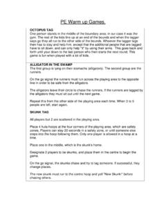
Transcription of Name: Date: Grid references and map symbols
1 name : date : grid references and map symbols Created by Mark Laird C:\Atestfolder\newcont\marklaird\ 18/11/00 grid reference Symbol Meaning Location 3934 Thanet Well Camp Site Near Brother s Water Triangulation Point Summit of Skiddaw (Near Keswick) 0994 Phone Box 1600 Beckfoot Ulpha 3988 Gummer s How 3795 5093 3308 Youth Hostel 1436 Moota Hill 4189 PH 4000 P 2583 Use the Lake District one inch to one mile Tourist Map to fill in the blank spaces in this chart.
2 name : date : grid references and map symbols Created by Mark Laird C:\Atestfolder\newcont\marklaird\ 18/11/00 grid reference Symbol Meaning Location 3934 Caravan Site Thanet Well 4011 Camp Site Near Brother s Water 2629 Triangulation Point Summit of Skiddaw (Near Keswick) 0994 Phone Box Newbiggin 1600 Station Beckfoot 1993 Church Ulpha 3988 Viewpoint Gummer s How 3795 Church with Tower Far Sawrey or Town End 5093 Golf Course Kendal Fell 3308 Youth Hostel Lancrigg 1436 Radio or TV mast Moota Hill 4189 PH Public House (pub)
3 Strawberry Bank 4000 P Post Office Troutbeck Bridge 2583 Wind Pump Brunt Riggs or Kirkby Moor Use the Lake District one inch to one mile Tourist Map to fill in the blank spaces in this chart. name : date : grid references and map symbols Created by Mark Laird C:\Atestfolder\newcont\marklaird\ 18/11/00 grid reference Symbol Meaning Location 0526 Triangulation Point Gatebarrow 1425 Caravan & Camp Site River Cocker (Whinfell Hall) 0916 Parking West End of Ennerdale Water 2313 Gradient Little Gatesgarthdale 2124 Picnic Site Near Lakeland View Whinlatter Forest 1122 (pink) Bunkhouse or camping barn Waterend 1724 Footpath Near High Swinside farm 2623 (red)
4 Bus / Coach station Keswick 1513 Coniferous Trees Ennerdale Forest 0316 Church with Spire Frizington 2623 Information Centre Keswick 2426 Main Road Near Thornthwaite Forest 2521 Deciduous Trees St Herbert s Island 1129 Youth Hostel Cockermouth Use the English Lakes North West 1:25 000 Outdoor Leisure Map 4 to fill in the blank spaces in this chart. name : date : grid references and map symbols Created by Mark Laird C:\Atestfolder\newcont\marklaird\ 18/11/00 grid reference Symbol Meaning Location 0526 Triangulation Point Caravan & Camp Site River Cocker (Whinfell Hall) 0916 Parking 2313 2124 Picnic Site 1122 Bunkhouse or camping barn 1724 (red) Keswick 1513 Coniferous Trees Frizington Information Centre Keswick 2426 Main Road Deciduous Trees St Herbert s Island Youth Hostel Cockermouth Use the English Lakes North West 1:25 000 Outdoor Leisure Map 4 to fill in the blank spaces in this chart.
5