Transcription of National Spatial Development Strategy for …
1 1 National SpatialDevelopment Strategyfor trinidad and TobagoSurveying the Scene2 CONTENTS1. 2. Population and Settlement Geographic Distribution ..Pattern and Form of 3. Society and Cultural Heritage and Recreation, Leisure and 4. Agriculture and Quarrying and Oil and Service 5. Ecosystems and the Services they Climate and 6. Waste Water and Wastewater Flood Risk Information Communication Technology (ICT).. Appendix Appendix List of FiguresFigure 1: Population Structure for 2000 and Forecast Change in 2020 and 2025 Figure 2: Population Density by Administrative Area, trinidad and tobago 2011 Figure 3: Population Change by Administrative Area 2000 2011 Figure 4: Distribution of Serious Crimes by Police Division (2010) Figure 5: Multidimensional Poverty by Regional CorporationFigure 6: Agricultural Land in trinidad and tobago (2010)Figure 7: Employment share and GDP contribution of economic sectors between 2010 and 2011 Figure 8: Protected areas in TrinidadFigure 9: Ecosystem Services DiagramFigure 10: Land-use coverage 1991 and 2010 Figure 11: Flood Risk in TrinidadFigure 12: Population and vehicle number change Figure 13: Landfill Sites in trinidad and TobagoFigure 14.
2 Energy Use Per $1000 GDPF igure 15: Renewable energy driversList of TablesTable 1: Area under cultivation in South Region by hectares and acreageTable 2: Issues contributing to traffic congestion457912121416171819202121212424 25262727303034383841434445484950513 National Spatial Development Strategy FOR trinidad AND TOBAGOList of AcronymsAPDSL All-Inclusive Project Development Services Limited CEDP Comprehensive Economic Development Plan CSO Central Statistical OfficeEIA Environmental Impact AssessmentEMA Environmental Management AuthorityGDP Gross Domestic ProductGHG Green House GasGIS Geographic Information SystemGORTT Government of the Republic of trinidad and TobagoICT Information and Communications TechnologyISWRMP Integrated Solid Waste Resource Management PolicyIWRMP Integrated Water Resources Management PolicyLSA Land Settlement AgencyMDPs Municipal Development PlansMEEA Ministry of Energy
3 And Energy AffairsMPE Ministry of Planning and the EconomyMTPF Medium Term Policy Framework, 2011-2014 NHDI National Human Development IndexNPDP National Physical Development PlanNSDS National Spatial Development StrategySIDS Small Island Developing StatesT&TEC trinidad and tobago Electricity CommissionUNFCCC United Nations Framework Convention on Climate ChangeWSD Working for Sustainable Development41. INTRODUCTIONThis document is a distillation of the key elements of the evidence base used to support the preparation of the National Spatial Development Strategy (NSDS). It identifies key issues, and presents facts and information in five main parts: population and settlement; society and culture; the economy the environment; and, order to illustrate how the analysis has been applied to the NSDS Core Strategy and Regional Guidance document, a text-box follows each section and identifies the relevant objective(s) and policy/policies.
4 5 National Spatial Development Strategy FOR trinidad AND TOBAGO2. POPULATION AND SETTLEMENT DISTRIBUTIONP lanning for efficient and effective use and management of trinidad and tobago s land and ocean space requires many demographic and related factors to be taken into account, including: population size and Spatial distribution; demand for housing, employment and goods and services; people s daily commuting patterns; settlement patterns, that is, people moving from one place to another/places losing population and others gaining; and, impacts on the economy, the environment and the social structure of the country. squatting and its implications for sustainable these are actually the results of people s collective decisions and activities on a daily basis. Planning decisions need to be informed by an understanding of both the effects of those decisions and the reasons they are and tobago s 2011 population of 1,328,0191 represents a increase since the 2000 Census2.
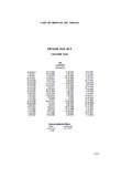
5 Whilst the population has continued to grow over the past 40 years, the rate of growth has been steadily declining since a peak in the 1970s-1980s, largely as a result of decline in the total fertility and birth rates. This is a normal pattern as a society develops. External migration particularly to North America has also been a significant factor during this forecast change to the population profile over the next decade is shown in Figure 1. It suggests that the population structure is in an advanced stage of demographic transition in which the number of children below the age of 15 years is decreasing while the number of persons over 60 years is increasing and the overall population size is trending toward a continuing decline in growth rate. The CSO 2009 projections suggest that the total population may decline from 1,324,019 to 1,309,589 by 2020 and further decline to 1,294,347 by 2025 due mainly to decreased fertility and emigration.
6 However alternative projections by the United Nations Population Division3 suggest likely slow growth during that period with medium variant forecasts of 1,349,000 in 2020 and 1,333,000 in 2015. All projections indicate likely increases in the old age dependency ratio in future, pointing to the need for a clearly defined population policy for forward planning. 1 Central Statistical Office, Ministry of Planning and Sustainable Development , 2012. 2 The research for this document was undertaken prior to the official 2011 Census figures being released. It is recognised that the population figure has now been revised to 1,328,019, which represents a increase (CSO, 2012). 3 UN Population, Dept of Economic and Social Affairs of the UN Secretariat World Population Prospects, 20126 Figure 1: Population Structure for 2000 and Forecast Change in 2020 and 2025 (CSO Annual Statistical Digest, 2009)Population Structure for 2020 Population Structure for 202580+70-7460-6450-5440-4430-3420-2410- 140-4-80000-60000-40000400006000080000-2 0000200000 MaleFemaleAge GroupNumber of Population (1,309,589)Population Structure for 2000-80000-60000-40000400006000080000-20 00020000080+70-7460-6450-5440-4430-3420- 2410-140-4 MaleFemaleNumber of Population (1,262,366)Age Group80+70-7460-6450-5440-4430-3420-2410 -140-4 MaleFemale-80000-60000-40000400006000080 000-20000200000 Age GroupNumber of Population (1,294,347)7 National Spatial Development Strategy FOR trinidad AND TOBAGOF acts and Figures Population of trinidad and tobago : 1,328,019 in 2011 (1,262,366 in 2000) trinidad .
7 1,267,145 in 2011 (1,208,282 in 2000) tobago : 60,874 in 2011 (54,084 in 2000)The populations of 4 of the 14 municipalities in trinidad declined between 2000 and 2011: Port of Spain down by ; San Fernando down by ; Diego Martin down by ; San Juan/Laventille down by less than 1%. In 2000, of trinidad s population lived in those four urban regions. By 2011 the proportion had decreased to 27% - a loss of just over 21,000 people from those core urban regions of trinidad in which populations increased most during the same period were: Chaguanas - population up by 16,083 ( ) Sangre Grande - population up by 11,423 ( ) Couva/Tabaquite/Talparo - population up by 15,631 ( )Taken together, those three regions have gained 43,137 people. The highest growth rate has been in Chaguanas and Couva/Ta-baquite/Talparo which, together, have accounted for over half of the total increase in trinidad s population between 2000 and 2011.
8 Between 2000 and 2011 the proportion of trinidad s people living in those regions increased from 19% to of tobago s parishes lost population between 2000 and 2011 and during that period the island s population increased from 54,084 to 60,874 (up by ). The highest percentage rate of population growth (28%) was in St George, and the four west-ern parishes St Patrick, St Andrew, St George and St David continuing to accommodate almost four fifths (80%) of the island s DistributionThe existing settlement pattern shows marked concentration of urban settlements in the western half of trinidad and the south-west of tobago . In trinidad , a large proportion of the island s population is concentrated in the highly urbanised regions of the East/West and North/South Corridors. By contrast, a much lower proportion of the National population lives in eastern trinidad , the deep southwest peninsula, and the north-east of tobago - all of which are relatively sparsely populated.
9 In general terms, those predominantly rural regions have been experiencing lower levels of social and economic Development with an associated poorer quality of life. The resulting regional imbalances are confirmed in the assessment of the National Human Development Index (NHDI) presented in the trinidad and tobago Human Development Atlas 20124 , which shows Sangre Grande and Mayaro/Rio Claro as having the lowest NHDI figures overall. tobago had the lowest average annual house-hold income per general trends do, however, mask the fact that there are substantial pockets of poverty and deprivation in the main urban areas, and some wealthy communities in the rural areas. Deprivation, both urban and rural, is an issue that needs to be tackled through integrated planning and administrative divisions also have implications with respect to the implementation of projects and programmes at the regional and local levels.
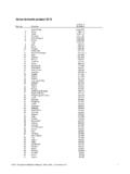
10 Development planning exercises, particularly at the National level, therefore must remain cognisant of the mechanisms, capacities and capabilities of these implementation agencies charged with Development . Often times, the interventions required for effectively addressing particular issues cross administrative boundaries and require coordination between two or more implementing bodies. This becomes especially important at the Municipal Corporation level where activities of the local government bodies and state agencies must be aligned to avoid duplication of efforts and ensure improved service delivery. 4 Central Statistical Office, Ministry of Planning and Sustainable Development , 20128 Population Density by Administrative Area, trinidad and tobago 2011 trinidad and tobago 2011 Population and Housing CensusDemographic Report0 - 5051 - 200201 - 400401 - 800801 - 1,2001,201 - 4,000 Persons per sq.