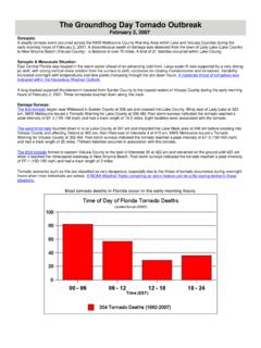
Transcription of National Weather Service Situation Report
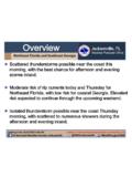
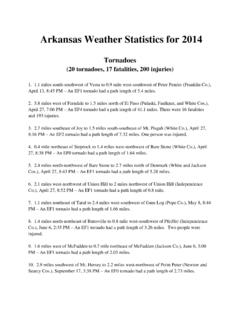
1 National Weather Service Situation Report City, State Great Falls, Montana Monday, October 7, 2019 8:37 PM. 2nd Fall Storm of the Season Early This Week Message of the Day: On Tuesday, a strong Canadian cold front will move southward through the region, ushering in much colder temperatures along with rain changing to snow. Accumulating snow is likely in many areas by Tuesday night, along with icy roads developing, as air temperatures fall below freezing. Important Forecast Changes: Everything is on track for a strong cold front to move through the region on Tuesday. Strong winds are still possible overnight in the Browning, Cut Bank and Sweet Grass areas ahead of the cold front. The cold front is likely to move southward through North Central MT on Tuesday morning. Expect quickly falling temperatures into the 20s and 30s, with any rain changing to snow. Click for a description of this product Click to evaluate this product National Weather Service Situation Report Great Falls, Montana Monday, October 7, 2019 8:37 PM.
2 Windy Monday into Tuesday Main Points Strong winds are still possible through the night near the Rocky Mountain Front and along the Highway 2 corridor from Browning to Chester. Click for a description of this product Click to evaluate this product National Weather Service Situation Report Great Falls, Montana Monday, October 7, 2019 8:37 PM. Winter Weather to Return To Montana Storm Total Snow Valid: Tuesday Morning thru Wednesday Night Click for a description of this product Click to evaluate this product National Weather Service Situation Report Great Falls, Montana Monday, October 7, 2019 8:37 PM. Winter Weather to Return To Montana Probability of 6 inches or more of Snow Valid: Tuesday Morning thru Wednesday Night Click for a description of this product Click to evaluate this product National Weather Service Situation Report Great Falls, Montana Monday, October 7, 2019 8:37 PM.
3 Temperatures will fall during the day Tuesday These images show the temperature change from Tuesday Morning to Tuesday Evening 7 AM Tuesday Quickly falling temperatures on Tuesday. 6 PM Tuesday Temperatures falling through the day over North Central MT. Click for a description of this product Click to evaluate this product National Weather Service Situation Report Great Falls, Montana Monday, October 7, 2019 8:37 PM. Timing of the Cold Front Estimated Cold Front Arrival Time Valid: Tuesday 7 AM Tuesday 11 AM. Tuesday 5 PM Tuesday Click for a description of this product Click to evaluate this product National Weather Service Situation Report Great Falls, Montana Monday, October 7, 2019 8:37 PM. Blowing Snow and Poor Visibility This map shows the potential area where blowing snow could cause areas of poor visibility Most likely area to have blowing snow impacts Click for a description of this product Click to evaluate this product National Weather Service Situation Report Great Falls, Montana Monday, October 7, 2019 8:37 PM.
4 Cold Temperatures by Wednesday Morning Click for a description of this product Click to evaluate this product National Weather Service Situation Report Great Falls, Montana Monday, October 7, 2019 8:37 PM. Much Colder on Wednesday Afternoon Click for a description of this product Click to evaluate this product National Weather Service Situation Report Great Falls, Montana Monday, October 7, 2019 8:37 PM. Even Colder Thursday Morning Click for a description of this product Click to evaluate this product National Weather Service Situation Report Great Falls, Montana Monday, October 7, 2019 8:37 PM. Some Safety Tips for the Cold Below are some safety tips on how to dress for the cold conditions expected. Make sure to dress the kids warm later this week. You will need full winter gear, which includes the hat, gloves, scarf, winter coats and boots in some areas.
5 Click for a description of this product Click to evaluate this product National Weather Service Situation Report Great Falls, Montana Monday, October 7, 2019 8:37 PM. Livestock Impacts Possible This is the Cold Advisory for Newborn Livestock Valid: Early Tuesday Evening Additional CANL forecasts at: Click for a description of this product Click to evaluate this product National Weather Service Situation Report Great Falls, Montana Monday, October 7, 2019 8:37 PM. Tuesday thru Wednesday Key Points Hazards: A Canadian front will move southward through the region on Tuesday, resulting in falling temperatures, poor driving visibility, icy roads and accumulating snow. Areas Impacted: All of North Central and Southwest MT will be impacted by some rain or snow and then colder temperatures by Wednesday. Timing & Duration:The cold front will arrive near the US /. Canadian border early Tuesday morning, and then moves southward into the Great Falls/Lewistown areas by Noon, arriving in Helena/Bozeman areas during the afternoon ane early evening hours.
6 The snow will end Wed. night, but the colder air will linger over the region until late in the week. Impacts: Strong northerly winds will create very poor driving visibility for a few hours along the cold front. Expect accumulating snow in many areas, and icy roads will develop as temperatures fall below freezing. Wind chills will fall into the single digits Tuesday night. Historical Perspective: We have had some snowy and cold conditions in the middle of October. Click for a description of this product Click to evaluate this product National Weather Service Situation Report Great Falls, Montana Monday, October 7, 2019 8:37 PM. Confidence High .For a transition from rain to snow and much colder conditions Tuesday into Wednesday. Medium For total snow accumulations and the potential for widespread icy roadways. The strong winds behind the cold front, combined with falling snow could make for very difficult travel conditions because of blowing snow.
7 Probabilistic Information At: Winter Weather Quick Facts and Preparedness: Quick facts you should know about winter Weather : Snow can occur at temperatures as high as 46 degrees if conditions are right. The record for most snowfall in the Lower 48 in a 24 hour period is at Silver Lake, Colorado in 1921. Blizzard conditions are met when visibility in falling and blowing snow reaches mile or less and sustained wind speeds of 35 mph or greater occur for 3 hours or more. As little as 1/16 of ice can begin to impact roadways and sidewalks. As the wind increases, the body is cooled at a faster rate. The wind chill is a way for meteorologists to communicate what the combination of wind and temperature feels like to exposed skin. Preparedness: - A Winter Storm Watch is issued when conditions are favorable for significant winter Weather and/or blizzard conditions.
8 Time to prepare! - A Winter Storm Warning is issued when a combination of heavy snow, blowing snow, and possibly ice mixed with snow is expected to impact the area. Time to act! - A Blizzard Warning is issued when the combination of strong wind, low visibility, and heavy snow will significantly impact daily life. Find out more information on our web page: Follow us on Facebook and Twitter for more up to date information: @NWSG reatFalls NWS Great Falls Click for a description of this product Click to evaluate this product