Transcription of Natural Hazards
1 Page 115 of 524 Natural Hazards Coastal Erosion Earthquakes Floods Landslides Severe Weather Drought Windstorms Winter Storms Tsunamis Volcanic Ashfall Wildfires Page 116 of 524 Coastal Erosion Introduction The Pacific Northwest (PNW) coast of Oregon is without doubt one of the most dynamic coastal landscapes in North America, evident by its long sandy beaches, sheer coastal cliffs, dramatic headlands and vistas, and ultimately the power of the Pacific Ocean that serves to erode and change the shape of the coast. Beaches and coastal bluffs are some of the most dynamic landforms, changing in response to waves, nearshore currents, tides, rain, and wind. The most important Natural variables that influence changes to the shape and width of the beach and ultimately its stability are the beach sand budget (balance of sand entering and leaving the system) and the processes (waves, currents, tides, and wind) that drive the changes.
2 Human influences associated with jetty construction, dredging practices, coastal engineering, and the introduction of non-native dune grasses have all affected the shape and configuration of the beach, including the volume of sand on a number of Oregon s beaches, ultimately influencing the stability or instability of these beaches. Location Table 22. Jurisdictions Subject to Coastal Erosion Jurisdiction Coastal Erosion Unincorporated Tillamook County Neskowin Oceanside-Netarts Pacific City Bay City Garibaldi Manzanita Nehalem Figure 54. Erosion at The Capes Condominiums, Oceanside, Oregon Notes: The Capes, a multi-million dollar condominium complex constructed on an old Holocene dune field adjacent to Oceanside. Due to erosion of the sand at the toe of the bluff during the 1997-98 El Ni o winter, the bluff face began to fail threatening several of the homes built nearest the bluff edge.
3 Source: DOGAMI Page 117 of 524 Jurisdiction Coastal Erosion Rockaway Beach Tillamook Wheeler Port of Tillamook Bay Port of Garibaldi Source: Derived from Final Draft Multi-Hazard Risk Report, Oregon Department of Geology and Mineral Industries, December 1, 2016 Hazard Characterization Geology and Geomorphology Tillamook County s geomorphic features include almost all those found along the Oregon Coast: plunging cliffs, rocky shorelines and shore platforms, wide and narrow beaches backed by dunes, gravel and cobble beaches backed by cliffs, barrier spits, and estuaries. Geomorphically, the coast can be broken up into a series of pocket beach littoral cells that reflect resistant headlands (chiefly basalt) interspersed with short to long stretches of beaches backed by both less resistant cliffs and dunes as is the case in Tillamook County.
4 The headlands effectively prevent the exchange of sand between adjacent littoral cells. Some beaches form barrier spits, creating estuaries or bays behind them ( , Netarts and Nestucca spits). Sand Budget The beach sand budget is the rate at which sand is brought into the coastal system versus the rate at which sand leaves the system. Potential sources of sand include rivers, bluffs, dunes, and the inner shelf. Potential sand sinks include bays (estuaries), dunes, dredging around the mouths of estuaries, and mining of sand. Sand volume is a factor in susceptibility of a bluff to failure from wave action causing erosion at its toe. Conversely, in some areas such as Pacific City and Manzanita excess sand build-up is a concern. Human Influences Population pressure on the Oregon coast is relatively low and is largely confined to small coastal cities separated by large tracts of coast with little to no development.
5 Tillamook County is home to some of these small cities. Although the processes driving coastal erosion on bluff-backed shores are entirely a function of the delicate balance between the assailing forces (waves, tides, and currents) and properties of the rock (rock type, bedding, strength, etc.), human influences along with extensive erosion caused by major storms have contributed to the need for coastal engineering (such as riprap) to protect individual properties. The magnitude and extent of these erosion events have now left these communities entirely dependent on the integrity of the engineered structures. Classifying Coastal Erosion Chronic or catastrophic? Beach, dune, and bluff erosion are chronic Hazards . They usually cause gradual and cumulative damage. However, storms that produce large winter waves, heavy rainfall, and/or high winds may result in very rapid erosion that can affect properties and infrastructure over a matter of hours.
6 Damage from chronic Hazards is generally less severe than that from catastrophic Hazards . Page 118 of 524 However, the wide distribution and frequent occurrence of chronic Hazards makes them a more immediate concern. Causes of Coastal Erosion Most coastal Hazards , coastal erosion among them, are the product of the annual barrage of rain, wind, and waves that batter the Oregon coast, causing ever-increasing property damage and losses. Coastal erosion may be further exacerbated by climate cycles such as the El Ni o Southern Oscillation, or longer-term climate cycles associated with the Pacific Decadal Oscillation. Waves Along dune- and bluff-backed shorelines, waves are the major factor affecting the shape and composition of beaches. Short-term beach and shoreline variability is directly dependent on the size of the waves that break along the coast, along with high ocean water levels, and cell circulation patterns associated with rip currents.
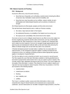
7 In contrast, long-term shoreline change is dependent on the balance of the beach sediment budget, changes in sea level over time, and patterns of storminess. Figure 55. Bluff Failure Due to Toe Erosion by Ocean Waves Note: The top of the bluff eroded landward by about 30 ft over a 48-hour period in November 2006. Photo source: OPDR The Oregon coast is exposed to one of the most extreme ocean wave climates in the world, due to its long fetches and the strength of the extratropical storms that develop and track across the North Pacific. These storms exhibit a pronounced seasonal cycle producing the highest waves in the winter. Summer months are dominated by considerably smaller waves, enabling beaches to rebuild and gain sand eroded by the preceding winter. When large waves are superimposed on high tides, they can Page 119 of 524 reach much higher elevations at the back of the beach, contributing to significantly higher rates of coastal erosion and flood Hazards .
8 It is the combined effect of these processes that leads to the erosion of coastal dunes and bluffs, causing them to retreat landward. Winds and waves tend to arrive from the southwest during the winter and from the northwest during the summer. Net sand transport tends to be offshore and to the north in winter and onshore and to the south during the summer. El Ni o events can exaggerate the characteristic seasonal pattern of erosion and accretion, and may result in an additional 60 80 feet of hotspot dune erosion along the southern ends of Oregon s littoral cells, particularly those beaches that are backed by dunes, and on the north side of estuary inlets, rivers and creeks. Ocean Water Levels The elevation of the sea is controlled in part by the astronomical tide. High ocean water levels at the shoreline may be the product of combinations of high tides, storm surges, strong onshore-directed winds, El Ni os, and wave runup.
9 Tides tend to be highest in the winter and lowest in the summer. The typical seasonal variability in water levels enables waves to break closer to dunes or along the base of coastal bluffs. Shoreline Changes Dune-backed beaches respond very quickly to storm wave erosion, sometimes receding tens of feet during a single storm and hundreds of feet in a single winter season. Beach monitoring studies undertaken by DOGAMI ( ) have documented storm induced erosion of 30 60 ft from single storm events, while seasonal changes may reach as much as 90 130 ft on dissipative, flat, sandy beaches. Furthermore, during the past 15 years a number of sites on the northern Oregon coast ( , Neskowin, Netarts Spit, and Rockaway Beach) have experienced considerable erosion and shoreline retreat. For example, erosion of the beach in Neskowin has resulted in the foredune having receded landward by as much as 150 ft since 1997.
10 South of Twin Rocks near Rockaway, the dune has eroded about 140 ft over the same time period. Continued monitoring of these study sites are now beginning to yield enough data from which trends (erosion or accretion rates) may be extrapolated. These latter datasets are accessible via the web ( ). Recently, studies undertaken by the USGS provide additional insights into the spatial extent of erosion patterns on the Oregon coast. Long-term erosion rates (albeit low rates) dominate the bulk of Tillamook County ( , Bayocean Spit, Netarts, Sand Lake, and Neskowin littoral cells), while accretion prevailed in the north along Rockaway Beach and on Nehalem Spit. The significant rates of accretion identified adjacent to the mouth of Tillamook Bay are entirely due to construction of the Tillamook jetties, with the north jetty completed in 1917 and the south jetty in 1974.