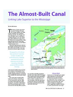
Transcription of NEW YORK STATE ROUTE 5 BUFFALO SKYWAY …
1 NEWYORKSTATEROUTE5 BUFFALOSKYWAYMANAGEMENTSTUDYEXECUTIVESUM MARYPIN , BIN 1001579 CITY OFBUFFALOERIECOUNTYOCTOBER2008In association with: SKYWAY Management StudyPIN / D025511 City of BUFFALO , Erie County Page ES-2 Executive SummaryIntroductionThe BUFFALO SKYWAY is an elevated steel bridge 100 feet over the BUFFALO River and miles inlength. It is an expressway link of New York STATE ROUTE 5 connecting the southern suburbs ofErie County with the Business District of the City of BUFFALO , northern suburbs of Erie Countyand Interstate 190. It serves local, regional, intrastate, national and international travelers. TheBridge is located at the edge of Central Business District of BUFFALO and directly interchangeswith Interstate SKYWAY has been the subject of considerable public debate in Western New York.
2 Much ofthe discussion has focused on its structural integrity and safety for vehicles traversing theelevated structure. Some community officials consider the bridge a barrier to Waterfrontdevelopment and feel that it occupies valuable real estate. Consequently, they want it New York STATE Department of Transportation commissioned this study to evaluate thefunctional STATE of the SKYWAY with respect to the following:xBridge Condition and VulnerabilitiesxExisting Traffic and Travel PatternsxFuture Traffic DemandsxAccident and Incident AnalysisxSkyway Bridge Management OptionsThis study was conducted to assemble factual information on the operational characteristics ofthe SKYWAY and make this information widely available to the public and community will use this information as the basis to guide future management decisions for study is not intended to evaluate alternatives to the SKYWAY if it were to be removed.
3 It iscertain that removal of the SKYWAY would have significant impacts to the regional highwaynetwork and travel patterns and would require a thorough analysis under the NationalEnvironmental Policy Act (NEPA) and the STATE Environmental Quality Review Act (SEQR).Such analysis is beyond the scope and intent of this of the SKYWAY and its associated on and off ramps began in 1950 and wascompleted in 1956 under five different contracts and at a cost of approximately $ million($129 million in 2006 dollars). The on and off ramps to the southbound I-190 were constructedunder two additional New York STATE Thruway Authority contracts.
4 The SKYWAY is a gradeseparated structure that carries traffic on ROUTE 5 over the BUFFALO River and BUFFALO Ship Canaland is approximately 5800 ft long and consists of 48 piers and 53 spans. In addition, there arefour ramps that provide access on and off the SKYWAY is elevated to provide 100 feet of vertical clearance above the low water elevationof the BUFFALO River and BUFFALO Ship Canal. The horizontal clearances for shipping under theSkyway Management StudyPIN / D025511 City of BUFFALO , Erie County Page ES-3 SKYWAY are 215 ft for the BUFFALO River and 193 ft for the BUFFALO Ship Canal. A number of GreatLakes freight ships pass under the SKYWAY each year.
5 According to the Coast GuardDistrict 9 (Cleveland) office, shipping on the BUFFALO River has fluctuated in the past few years,with usage currently on the rise. The office was unable to provide an exact usage numberwithout completing additional from local shipping enthusiasts, who monitor commercial shipping traffic and areassociated with the group great Lakes and Seaway shipping , indicate that there wereapproximately 45 commercial transits of the 2 channels under the SKYWAY in 2006 (Each transitis comprised of one trip up and one trip down the channel, or a total of 90 passages under thebridge). In addition, an additional 50 transits were made by the Fire Tug Cotter and her icebreaking trips, great Lakes towing tugs, and marine tugs moving barges.
6 Occasional dredgingoperations also increase channel marine traffic. A proposed Ethanol plant located upstream ofthe BUFFALO River from the SKYWAY could add another 45 transits per year. Marinasimmediately north of the SKYWAY moor numerous high mast sail boats that may occasionallywish to head south under the SKYWAY Structural ConditionsThe superstructure of the bridge, excluding the deck, is constructed of steel. The piers locatedadjacent to and north of the I-190 underpass are also built of steel, along with the piers on RampC and the Thruway Loop Ramp. A paint system is used to protect the steelwork from original paint system and some subsequent coats used lead based paint with asbestos 1999 to 2005 a project was undertaken, and progressed under several contracts, to removethe lead-based asbestos-containing paint from the SKYWAY and repaint the steel.
7 In 1994, aseparate contract was let to replace the deteriorated steel catwalk system that runs under thedeck. The catwalk allows for bridge maintenance and inspection access. Other deterioratedsteel components, including floor beams and stringers, were also repaired or replaced at concrete was used for the construction of the deck, abutments, a majority of thepiers, and all of the pier footings. The concrete piers that support the SKYWAY are generally ingood condition with some delamination and spalling at the tops of several piers. In 1990, theconcrete substructures underwent an extensive $ rehabilitationThe structural conditions of the SKYWAY structure indicate that today, the primary andsecondary steel members are generally in good condition with some areas of minordeterioration.
8 These areas of minor deterioration appear to be localized primarily to webstiffeners, lower web plates, connection plates and cover plates and do not affect the structuralintegrity of the The concrete deck of the SKYWAY is generally in fair condition. Traffic Volumes and SpeedsTo obtain the travel characteristics of vehicles crossing the SKYWAY Bridge, several datacollection efforts occurred. Peak hour manual counts were collected for 20 highway and bridgeSkyway Management StudyPIN / D025511 City of BUFFALO , Erie County Page ES-4locations and a continuous machine count on the bridge was conducted. Vehicles wererecorded by type during the manual peak hour commuter counts to identify heavy vehicles those with either two or more axles or vehicles with dual tires on at least one axle.
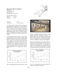
9 During thecontinuous count effort, vehicles were counted by direction of travel as they crossed the bridgeand locations of distribution. This information provided a clearer picture of the directional biasof travelers during peak commuter show that the Annual Average Daily Traffic volume (AADT) on the SKYWAY is 43,400vehicles as measured in 2008 by NYSDOT. Approximately 4,500 vehicles use the SKYWAY inboth the eastbound and westbound directions during the AM peak hour and 3,900 vehiclesduring the PM peak hour. Of those vehicles, percent are considered heavy ES-1A and ES-1B show the peak hour volumes. Table ES-1 is a summary of trafficvolumes. Figure ES-2 shows the distribution of SKYWAY traffic as it approaches I-190 and thedowntown City of BUFFALO Travel Time & Delay study was performed for four roads that included segments of:a)NYS ROUTE 5 between Church Street and Tifft Streetb)Ohio Street between Michigan Street and NYS ROUTE 5c)South Park Avenue between Michigan Street and Bailey Avenued)Interstate 190 between Elm/Oak Interchange and I-90 InterchangeThe study was conducted during weekday peak period commuter times by direction of travel inbound and outbound toward the Central Business District of the City.
10 The travel timeinformation collected quantified the typical peak period operating speeds of vehicles. Typically,vehicles during the morning commuter period travel on the bridge at a speed of approximately56 mph outbound from and 48 mph inbound toward the City. During the afternoon peakcommuter period, traffic typically travels 53 mph inbound toward the City and 55 mphoutbound from the Management StudyPIN / D025511 City of BUFFALO , Erie County Page ES-5 Figure ES-1 AYear 2008 Peak Hour Volumes Upper Bridge SectionSkyway Management StudyPIN / D025511 City of BUFFALO , Erie County Page ES-6 Figure ES-1 BYear 2008 Peak Hour Volumes Slip Ramps of NY ROUTE 5 SKYWAY Management StudyPIN / D025511 City of BUFFALO , Erie County Page ES-7 Table ES-1 SKYWAY Bridge Traffic & Travel Patterns - Year 2008 TRAFFIC VOLUMESDAILY43,400AM PEAK HOUR4,500PM PEAK HOUR3,900 DIRECTIONAL FLOW OF VOLUMESAM PEAK HOUR76 % INBOUND.