Transcription of North Park Blazed Trails - Central Section - …
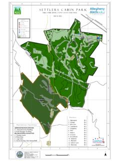
1 North park Blazed Trails - Central Section06601,3201,9802,640330 FeetLegendPark BoundaryRachel Carson TrailOther TrailsPark BldgsSheltersBallfieldsParking Lots1 inch = 1,250 feet1:15,000 Scale - ###########################Irwin RdKummer RdLake Shore DrWalter RdPearce Mill RdMckinney RdTennis Ct RdGrubbs RdBabcock BlvdBrown RdIngomar RdCompost RdN Ridge DrPearce Mill RdKummer RdAABBCCDDEEFFGGHH998877665544332211 HIKLMN N Ridge DrNorth RidgeLake ShoreDrKummer Rd Golf CourseRanch HouseShelterJC StoneFieldHillsideShelterRoosevelt ShelterLathamShelterAdministrationBuildi ngSkatingRinkPigeonShelterWisconsinShelt erGolfCourseClubhouseParish HillShelterCabinShelterWashingtonShelter WyomingShelter OlympiaShelterDr North park LakeMarshall Lake345891011NM7 IKLJ6GH GJ3456 Grid squares
2 Areapproximately1170 feet long on each North ParkEnlargedArea trail Blaze SymbolsDotted blazes have been used as well as the normal solid blaze(a red rectangle symbolized by a solid red line on the map for the North Ridge trail ). eg: A red blaze with a blue dot is symbolizedby a solid red line with blue blaze with a triangular cap marks an access clarify the blazes, a blaze symbol points to its correspondingblazed trail . Solid Dotted Access Blaze Blaze trail LodgeIngomarBabcockBlvdBabcock BlvdBeaver Shelter StPaulLuthrn Ridge Map Created January 21, 2011- BMc:Allegheny County Division of Computer Services Geographic Information Systems 621 County Office Building542 Forbes AvenuePittsburgh, PA 15219(412) 350-4760 Pearce Mill RdRevised October 3, 2011


![Praecipe to Settle, Discontinue & Satisfy [Form-243]](/cache/preview/2/1/e/b/9/c/1/e/thumb-21eb9c1e7ffe8279f80e179e67a93593.jpg)