Transcription of North Raccoon River Map 1 £¤ SAC - sac county,iowa
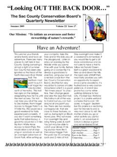
1 Downstream of Adel on the North RaccoonA rock dam at the Bennett Access. The North Raccoon River is a mostly freeflowing River surrounded by rural areas in a wooded val-ley. It is known as a place of solitude and good fishing. At its upper navigable reaches in Sac County, the River flows through a heavily glaciated area with unique scenery. A dozen rock dams (also known as fishing riffles) can be navigated by experienced paddlers, but many will wish to portage them. One low-head dam at Adel must be portaged on the designated path. Clay bluffs, along with occasional rock outcroppings, can be observed at various points along the River . Near Van Meter, the North and South branches converge to form the Raccoon River . Commerce Ledges at Walnut Woods State Park forms rapids at moderate to high flows that can be challenging -- it can be portaged on the River right. Channel catfish can be caught at deeper pools, near log jams, and along cut fish species present: Channel catfishMinor fish species present: Bullhead, smallmouth bass, flathead catfish, walleye""""""!
2 !!!!!!!!!!!!!!!!!!!!!!!!!!!!!!!!!!!!!!!! !!!!!!!!!!!############################# ####################### 39 4 415 44 17 144 4 71 173 50 221 46 9 36 124 401 930 45 383 160 141 25 30 175 7 928 141 4 175 928 28 5 69 71 20 69 6 80 35 235!!GUTHRIEDALLASBOONEGREENECALHOUNSACC ARROLLPOLK 14145 miN1 Middle Raccoon RiverLake CitySac CityJeffersonCoon RapidsPerryAnkenyUrbandaleGrimesDes MoinesPanoraCarrollDallas CenterAdelVan MeterLindenRaccoonRiverNorthRaccoonRiver !!|Chatauqua ParkHyde ParkHagge ParkGrant ParkVogel AccessRainbow BendHobbs AccessWright AccessButrick BluffRichey AccessSnyder AccessP-28 AccessCowles AccessJackson AccessBennett AccessHenderson ParkRiverside ParkShearer AccessCommerce LedgesMcDonald AccessSac City Access(DNR Wildlife)Perry Boat RampSportsmen's ParkAdel Island ParkHighway 44 AccessTwo RiversBoonevilleAccessWhite Horse AccessMcMahon AccessBrown Bridge AccessNations Bridge ParkNorth RaccoonAccessSquirrel Hollow ParkAdkins Bridge AccessSpring Valley AccessSpringbrook State ParkHighway 141 River AccessMarlowe RayMcCammond AccessDes MoinesWaterworks ParkKinnick-FellerRiverside ParkMerritt AccessCarroll County AccessWalnut WoodsState ParkAlmer Noyd Wildlife AreaSouth RaccoonAccessMiddle RaccoonRiver AccessEarlhamBridgePleasantValley!
3 L!l!l!l!l!l!l!l!l!|!|!|!|!|!|!|!|!|!|!|! |!|!|!|!|!|!_!_!_!_!_!_!_!_!_!_!_!_!_!_! _!|!y!y!y!y!y!y!y!y!y!y!y!y!y!y!y!y!y!y! y!y!y!y!y! ! ! ! ! ! ! ! ! ! ! ! ! !9!9!9!9!9!9!9!9!9!9!9!9!9!9!9!9!9!9!9!9 !9!m!m!m!m!m!m!m!m!m!m!m!m!m!n!n!n!n!nLa ke Panorama Dam!nLenon Mill DamRedfield DamWater Works DamScott StreetDamPuckerbrushAccess!|6 North Raccoon River Map 1 North Raccoon River and Raccoon River Map 2 Portaging at Adel. The North Raccoon s clay bluffs in Greene County. Legend nm|y9 Hard-surface boat rampCarry down accessCampgroundRapids or rock damDam (danger!)Drinking water near River !_Restroom5-mile markers, from mouthWatercraft campsiteFederal or state highwayCity or townPaved & unpaved roadsPublic land!lFishing access|Unmaintained accessThe Raccoon River in West Des Moines and Des Moines offers a tranquil greenbelt in the heart of Iowa s most urbanized area. Expedition & Fishing GuideNorth Raccoon River , South Raccoon River , Middle Raccoon River , and Raccoon RiverWater TrailsIowaBe safe out there!
4 Wear a life jacket!They really do save lives. It won t work if you don t wear t boat under the influenceFor your safety, don t use alchohol or drugs on the water. Watch for hazardsOn rivers, hazards like dams, fences, snags, rocks, and bridge abuttments may be present. Dams and snags in particular can be killers. Avoid them!Plan to get wet!You may capsize, so dress for the weather. When the water and/or weather get cold, warm-when-wet clothing and a wetsuit are legal!Most land along these rivers is privately owned these waters are navigable and open to the public, but you must respect private is a crime pack out everything you bring in. Report littering or dumping by calling environmental problems (fish kills, contaminants, etc.) to the Field Ofiice serving the county you are in:Polk/Dallas: (515) 725-0268 Guthrie/Greene/Carroll: (712) 243-1934 Calhoun/Sac: (712) 262-4177 ResourcesSee for water trails information and our most recent listing of canoe/kayak or Middle Raccoon River is a spir-ited central Iowa River that straddles the edge of a past glacial advance.
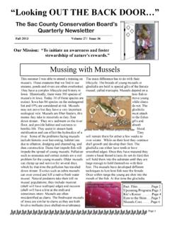
5 In the area near Coon Rapids, the River passes scenic sandstone bluffs within the Whiterock Conservancy, a land trust that is open to the public for recreation. Frequent boulders and riffles dot the streambed between Panora and Redfield, an area designat-ed as a Protected Water Area. Downstream of Redfield, it passes a limestone bluff called Hanging Rock before it becomes known as the South Raccoon , where the smaller South Raccoon tributary enters. Smallmouth bass fishing is popular in the Protected Water Area segment, and catfishing is popular throughout. Due to private banks at Lake Panorama, there is no legal way to travel from Springbrook State Park to the Lenon Mill Dam access. The lake does settle out sediments, creating a relatively clear stream below Panora. Snags, mid-water boulders, and pools are good places to try your luck at South Raccoon River is a small, riffly stream. In the section upstream of the confluence with the Middle Raccoon , the South Raccoon has suitable water levels for paddling only after moderate rains.
6 Numerous sandstone outcroppings line its banks, and some areas feel wild and remote. Downstream of the confluence with the Middle Raccoon , the River passes additional rock outcroppings -- this beautiful section can be navigated for more of the paddling season. Major fish species present: Channel catfishMinor fish species present: Bullhead, smallmouth bass, flathead catfish, walleye, largemouth bassHanging Rock on the Middle Raccoon RiverFederal regulations prohibit discrimination on the basis of race, color, national origin, sex or handicap. State law prohibits discrimination on the basis of race, color, creed, sex, sexual orientation, gender identity, religion, national origin, or disability. If you believe you have been discrimi-nated against in any program, activity or facility as described above, or if you desire further information, please write to the Iowa DNR, Wallace State Office Building, 502 E. Ninth St., Des Moines, Iowa, 50319.
7 """"""!!!!!!!!!!!!!!!!!!!!!!!!!!!!!!!!!! !!!!!!!!!!!!!!!!!!###################### ############################## 39 4 415 44 17 144 4 71 173 50 221 46 9 36 124 401 930 45 383 160 141 25 30 175 7 928 141 4 175 928 28 5 69 71 20 69 6 80 35 235!!GUTHRIEDALLASBOONEGREENECALHOUNSACC ARROLLPOLK 14145 miN1 CitySac CityJeffersonCoon RapidsPerryAnkenyUrbandaleGrimesDes MoinesPanoraCarrollDallas CenterAdelVan MeterLindenRaccoonRiverNorthRaccoonRiver RaccoonRiverSouthMiddleRaccoonRiver!!|Ch atauqua ParkHyde ParkHagge ParkGrant ParkVogel AccessRainbow BendHobbs AccessWright AccessButrick BluffRichey AccessP-28 AccessCowles AccessJackson AccessBennett AccessRiverside ParkShearer AccessMcDonald AccessSac City Access(DNR Wildlife)Two RiversBoonevilleAccessWhite Horse AccessMcMahon AccessBrown Bridge AccessNations Bridge ParkNorth RaccoonAccessSpringbrook State ParkHighway 141 AccessMarlowe RayMcCammond AccessMerritt AccessCarroll County AccessAlmer Noyd Wildlife AreaSouth RaccoonAccessMiddle RaccoonRiver AccessEarlhamBridgePleasantValley!
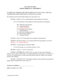
8 L!l!l!l!l!l!l!l!|!|!|!|!|!|!|!|!|!|!|!|! |!|!_!_!_!_!_!_!_!_!_!|!y!y!y!y!y!y!y!y! y!y!y!y!y!y! ! ! ! ! ! ! !9!9!9!9!9!9!9!9!9!9!9!9!9!9!9!m!m!m!m!m !m!m!m!m!m!n!nLake Panorama Dam!nLenon Mill DamRedfield Dam(no portage)(portage on River right) 4 415 44 17 73 144 28 316 1739 30 141 25 141 4 175 141 71 20 20 69 6 71 80 35 235 Sac CityJeffersonCarrollLake CityCoon RapidsPanoraRedfieldAdelDes MoinesPerryDallas CenterNorth Raccoon RiverMiddle Raccoon RiverSouth Raccoon RiverRaccoon RiverMIDDLE & SOUTH Raccoon MAPNORTH Raccoon & Raccoon MAP #1 North Raccoon & Raccoon MAP #2 Middle Raccooon River and South Raccoon River MapSnow-covered bluffs at the Whiterock nm|y9 Hard-surface boat rampCarry down accessCampgroundRapids or rock damDam (danger!)Drinking water near River !_Restroom5-mile markers, from mouthWatercraft campsiteFederal or state highwayCity or townPaved & unpaved roadsPublic land!lFishing access|Unmaintained access