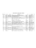
Transcription of OPEN LANDFILL SITES - Lower Rio Grande Valley …
1 open LANDFILL SITES MSWLF_ID FAC_ID NAME site LOCATION PLACE COUNTY OP_COMPANY 1273 TX01273 brownsville NAVIGATION DISTRICT 2000FT ENE INTERSECTION OF oklahoma & MEDEORD AVE brownsville CAMERON brownsville , city OF 151 TX00151 C&T REGIONAL LANDFILL 4 M W OF US 281 ON FM1017 LINN TX EDINBURG HIDALGO C&T REGIONAL LANDFILL 956B TX00956 city OF EDINBURG N & .4M E OF US 281 EDINBURG HIDALGO EDINBURG, city OF 1727 TX01727 HIDALGO COUNTY W OF FM1427 ON MILITARY HIGHWAY PENITAS HIDALGO HIDALGO COUNTY 1948 TX01948 BFI REGIONAL DISPOSAL FACILITY 1300 FT E FM493, N IH 83 DONNA HIDALGO BFI REGIONAL DISPOSAL FACLITIY 2131 TX02131 city OF HARLINGEN MI E INTERSECTION LOOP 499/FM106 ON N SIDE FM106 HARLINGEN CAMERON city OF HARLINGEN BASIC IDENTIFICATION INFORMATION COG Name: Lower Rio Grande Valley Development Council County Name: Cameron County site Number.
2 1273, open LANDFILL CURRENT OWNER city of brownsville / brownsville Navigation District Date of Operation: 1979 to Present Box 3070 Permit amendment application for a horizontal expansion joining existing sections brownsville , TX 78523-3070 of the LANDFILL and will be contained the existing permit boundaries.
3 Vertical Ph: 548-6000; LANDFILL ph: 831-3641 expansion will consist of raising the top elevation for the complete LANDFILL from a maximum of 47 feet near sea level (mgl) to a maximum elevation of 190 feet mgl. LOCATION AND BOUNDARY DESCRIPTION Confidence Level: Files are accurate and exact, retrieved from TNRCC files and owner files. Geographic Location: North 25 degrees 56 minutes 9 seconds West 97 degrees 23 minutes 24 seconds Location Description: From Highway 77/83 exit FM 802, proceed east pm 802 until the road ends at the city of brownsville Municipal LANDFILL .
4 Boundary Description: A permitted acres located approximately 3 miles northeast of brownsville , miles northeast of the intersection of Highway 4 and FM 511, 2 miles northeast of brownsville International Airport and miles south of warehouse Road. Map(s): Aerial and site Map BASIC IDENTIFICATION INFORMATION COG Name: Lower Rio Grande Valley Development Council County Name: Hidalgo County site Number: 151, open LANDFILL CURRENT OWNER C & T Regional LANDFILL Date of Operation: 1984 to Present PO Box 316 Originally issued to Hidalgo County/Pct.
5 4 on 3/5/76. Transferred to C & T Linn, TX 78563 Cattle Co. 3/13/84 and reissued to C & T on 8/2/84. LANDFILL ph: 383-7398 LOCATION AND BOUNDARY DESCRIPTION Confidence Level: Files are accurate and exact from TNRCC and owner Geographic Location: North 26 degrees ' West 98 degrees ' Location Description: 4 Miles West of US 281 on FM 1017 LINN TX Boundary Description: The site contains an area of approximately acres and is located on the south side of FM 1017, miles west of the intersection of US 281 and FM 1017, northwest of Edinburg, TX Map(s).
6 Aerial and site map. BASIC IDENTIFICATION INFORMATION COG Name: Lower Rio Grande Valley Development Council County Name: Hidalgo County site Number: 956B, open LANDFILL CURRENT OWNER city of Edinburg Date of Operation: 1976 to Present Box 1079 Expansion submitted - June 18, 2002 Edinburg, TX 78540 Ph: 383-5661; LANDFILL ph: 381-5652 LOCATION AND BOUNDARY DESCRIPTION Confidence Level: Files are accurate and exact from TNRCC files & owner.
7 Geographic Location: North 26 degrees 23 minutes 70 West 78 degrees 07 minutes 90 Location Description: Miles N & Miles E of US 281 (254 acre site ) Boundary Description: Lot 1-10 of Block 50 Citrus Fruit Development Council. Hidalgo County, TX Map(s): Aerial and site map. BASIC IDENTIFICATION INFORMATION COG Name: Lower Rio Grande Valley Development Council County Name: Hidalgo County site Number: 1727, open LANDFILL CURRENT OWNER Jose Ramirez Jr.
8 Date of Operation: Box 68 Property Owner Affidavit: October 18, 1984 Pe itas, TX 78540 Ph: 318-2600 or 519-3756 LOCATION AND BOUNDARY DESCRIPTION Confidence Level: Files accurate to the best extent possible, retrieved from Hidalgo County Precinct 3 staff. Geographic Location: N. 26E ', W. 98E ' Location Description: Miles W of FM 1427, 500 Ft.
9 North of Military Highway Boundary Description: A tract of land containing acres being all of Tract 325 and 326, Los Ejidos de Reynosa Viejo Grant, Hidalgo County save and except acres more or less out of the south eastern part of said tract 325 as conveyed to Felipe Garcia recorded in Volume 438. Map(s): Aerial and site Map Landuse, Ownership and Land Unit Information: Active LANDFILL BASIC IDENTIFICATION INFORMATION COG Name: Lower Rio Grande Valley Development Council County Name: Hidalgo County site Number: 1948, open LANDFILL CURRENT OWNER BFI Regional Disposal Facility Date of Operation: January 19, 1994 - Present 493 Mile 12 Rd.
10 Donna, TX 78537 LANDFILL ph: 464-7871 LOCATION AND BOUNDARY DESCRIPTION Confidence Level: Files accurate and exact from owner. Geographic Location: Along centerline of a ft. county road (Mile 12 North), North 80 degrees 51' East 2, to the point of beginning and containing acres of land. Location Description: 1300 Ft E FM 493 & Mile N IH 83 (FM 493 at Mile 12 Road) Boundary Description: gross acres of land being Block 68, 69, 57 and part of Block 56, La Blanca "B" Subdivision. Map(s): Aerial and site map Documents: Metes and Bounds BASIC IDENTIFICATION INFORMATION COG Name: Lower Rio Grande Valley Development Council County Name: Cameron County site Number: 2131 CURRENT OWNER Ruben Diaz, Director of Public Works Dates of Operation.