Example: marketing

Otis Pike Cooperative Hunting Area w

otis pike Cooperative Hunting area LegendParkingRoads Stream or Waterbody Restricted - No Hunting Cooperative PropertyDEC Property 40 39 3637 53 44 45 52 (2) 4 6 7 1 2 83 5 38A 9 12 10 11 50 49 61W 60A (2) 14 15 54 55 17 19 18 56A 57A 48 21 20 51W 22 24 25 59 58 43 23 26 27 28 29 30 31 32 33 42 66A 13A 16A 34 (2) 35 (2) 47 46 41 0 1 2 Miles Sources: Esri, HERE, DeLorme, USGS, Intermap, increment P Corp., NRCAN, Esri Japan, METI, Esri China (Hong Kong), Esri (Thailand), MapmyIndia, OpenStreetMap contributors, and the GIS User community

Kong), Esri Korea, Esri (Thailand), NGCC, (c) OpenStreetMap contributors, and the GIS User Community Legend Roads w Hunter Parking Area- number (1) indicates quota - A indicates archery only - W indicates waterfowl only Restricted - No Hunting Waterbody Suffolk County Parks Coopertive Hunting Area NYSDEC Ü Otis Pike Cooperative Hunting Area 01 ...

Tags:

  Area, County, Community, Pike, Hunting, Cooperative, Otis, Suffolk, Suffolk county, Otis pike cooperative hunting area

Information

Domain:

Source:

Link to this page:

Please notify us if you found a problem with this document:

Other abuse

Transcription of Otis Pike Cooperative Hunting Area w

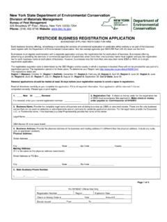
1 otis pike Cooperative Hunting area LegendParkingRoads Stream or Waterbody Restricted - No Hunting Cooperative PropertyDEC Property 40 39 3637 53 44 45 52 (2) 4 6 7 1 2 83 5 38A 9 12 10 11 50 49 61W 60A (2) 14 15 54 55 17 19 18 56A 57A 48 21 20 51W 22 24 25 59 58 43 23 26 27 28 29 30 31 32 33 42 66A 13A 16A 34 (2) 35 (2) 47 46 41 0 1 2 Miles Sources: Esri, HERE, DeLorme, USGS, Intermap, increment P Corp., NRCAN, Esri Japan, METI, Esri China (Hong Kong), Esri (Thailand), MapmyIndia, OpenStreetMap contributors, and the GIS User community


Related search queries