Transcription of Owner’s Manual - Garmin International
1 F nix . owner 's Manual May 2013 190-01507-00_0B Printed in Taiwan All rights reserved. Under the copyright laws, this Manual may not be copied, in whole or in part, without the written consent of Garmin . Garmin reserves the right to change or improve its products and to make changes in the content of this Manual without obligation to notify any person or organization of such changes or improvements. Go to for current updates and supplemental information concerning the use of this product. Garmin , the Garmin logo, and TracBack are trademarks of Garmin Ltd. or its subsidiaries, registered in the USA and other countries. ANT + , BaseCamp , chirp , f nix , Garmin Connect , GSC , and tempe are trademarks of Garmin Ltd.
2 Or its subsidiaries. These trademarks may not be used without the express permission of Garmin .. The Bluetooth word mark and logos are owned by the Bluetooth SIG, Inc. and any use of such marks by Garmin is under license. Mac is a registered trademark of Apple Computer, Inc. Windows is a registered trademark of Microsoft Corporation in the United States and other countries. Other trademarks and trade names are those of their respective owners. This product is ANT + certified. Visit directory for a list of compatible products and apps.. Table of Contents Setting the Alarm .. 6. Starting the Countdown Timer .. 6. 1 Using the Stopwatch .. 7. Getting Started .. 1 Adding a Custom Time Zone .. 7. Charging the Device.
3 1 Editing a Custom Time Zone .. 7. Keys .. 1 Alerts .. 7. Sensors .. 1 Setting a Proximity Alarm .. 7. Viewing the Sensor Data .. 1 Calculating the Size of an Area .. 7. Turning on a Sensor Mode .. 2 Viewing the Almanacs .. 7. Acquiring Satellites .. 2 Viewing Satellite Information .. 7. Stopping GPS .. 2 Simulating a Location .. 7. Going for a Hike .. 2 Customizing Your 7. Sending Your Hike to BaseCamp .. 2 Setup Overview .. 7. Profiles .. 2 Customizing the Main Menu .. 8. Changing Profiles .. 2 Customizing the Arrow Keys .. 8. Creating a Custom Profile .. 2 Customizing the Data Pages .. 8. Deleting a Profile .. 3 System Settings .. 8. Waypoints, Routes, and Tracks .. 3 About UltraTrac .. 8. Waypoints.
4 3 Compass Settings .. 8. Creating a Waypoint .. 3 Setting the North Reference .. 8. Finding a Waypoint by Name .. 3 Altimeter Settings .. 9. Finding Nearby Locations .. 3 Setting the Device Tones .. 9. Navigating to a Waypoint .. 3 Display Settings .. 9. Editing a Waypoint .. 3 Map Settings .. 9. Increasing the Accuracy of a Waypoint Location .. 3 Track Settings .. 9. Projecting a Waypoint .. 3 Time Settings .. 9. Deleting a Waypoint .. 3 Changing the Units of Measure .. 9. Deleting All Waypoints .. 3 Position Format Settings .. 9. Routes .. 4 Fitness Settings .. 9. Creating a Route .. 4 Setting Your Fitness User Profile .. 9. Editing the Name of a Route .. 4 About Lifetime Athletes .. 10. Editing a Route.
5 4 Geocache Settings .. 10. Viewing a Route on the Map .. 4 10. Deleting a Route .. 4 Customizing Your Running or Cycling Profile .. 10. Reversing a Route .. 4 Going for a Run .. 10. Tracks .. 4 History .. 10. Recording a Track .. 4 Viewing an Activity .. 10. Saving the Current Track .. 4 Saving an Activity as a Track .. 10. Viewing Details about the Track .. 4 Deleting an Activity .. 10. Clearing the Current Track .. 4 Using Garmin Connect .. 10. Deleting a Track .. 4 ANT + 10. Sending and Receiving Data Wirelessly .. 4. Pairing ANT+ Sensors .. 10. Garmin Adventures .. 4. tempe .. 10. Putting On the Heart Rate Monitor .. 10. Navigating to a Destination .. 5 About Heart Rate Zones .. 11. Navigating with Sight 'N Go.
6 5 Fitness Goals .. 11. Compass .. 5 Setting Your Heart Rate Zones .. 11. Calibrating the Compass .. 5 Tips for Erratic Heart Rate Data .. 11. Map .. 5 Foot Pod .. 11. Browsing the Map .. 5 Setting the Foot Pod Mode .. 11. Navigating Using TracBack .. 5 Going for a Run Using a Foot Pod .. 11. Altimeter and Barometer .. 6 Foot Pod Calibration .. 12. Calibrating the Barometric Altimeter .. 6 Calibrating Your Foot Pod by Distance .. 12. Tracking Weather Changes Overnight .. 6 Calibrating Your Foot Pod by GPS .. 12. Marking and Starting Navigation to a Man Overboard Calibrating Your Foot Pod Manually .. 12. Location .. 6 Using an Optional Bike Cadence Sensor .. 12. Geocaches .. 6 Device 12. Downloading Geocaches.
7 6 Viewing Device Information .. 12. Navigating to a Geocache .. 6 Updating the Software .. 12. Logging the Attempt .. 6 Device Care .. 12. chirp .. 6 Cleaning the Device .. 12. Finding a Geocache with a chirp .. 6 Specifications .. 12. 6 Heart Rate Monitor Specifications .. 12. Clock .. 6 Battery Information .. 12. Heart Rate Monitor Battery .. 12. Table of Contents i Replacing the Heart Rate Monitor Battery .. 12. Caring for the Heart Rate Monitor .. 13. Data Management .. 13. File Types .. 13. Disconnecting the USB Cable .. 13. Deleting Files .. 13. Troubleshooting .. 13. Locking the Keys .. 13. Resetting Your Device .. 13. Resetting the Device to Factory Settings .. 13. Clearing All Sensor Plot Data.
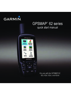
8 13. Getting More Information .. 13. Data Fields .. 13. Data Pages .. 15. Registering Your Device .. 15. Software License Agreement .. 15. Altimeter and Barometric Readings .. 15. Heart Rate Zone Calculations .. 16. ii Table of Contents Introduction Keys WARNING. Always consult your physician before you begin or modify any exercise program.. See the Important Safety and Product Information guide in the product box for product warnings and other important information.. Getting Started When using your device the first time, you should complete these tasks to set up the device and get to know the basic features.. Select to turn the backlight on and off. Hold to turn the 1 Charge the device (page 1).. device on and off.
9 2 Register the device (page 15). Select to scroll through the data pages, options, and 3 Learn about the sensor data and modes (page 1). settings.. 4 Acquire satellites (page 4). Select to scroll through the data pages, options, and settings.. 5 Go for a hike (page 2). Select to return to the previous screen. Hold to view 6 Create a waypoint (page 3).. the status page.. Orange key Select to open the menu for the current screen. Select Charging the Device . to choose an option and to acknowledge a message.. NOTICE Hold to mark a waypoint.. To prevent corrosion, thoroughly dry the contacts and the Viewing the Status Page surrounding area before charging or connecting to a computer. You can quickly switch to this page to view the time of day, battery life, and GPS status information from any other page.
10 The device is powered by a built-in lithium-ion battery that you can charge using a standard wall outlet or a USB port on your Hold .. computer.. 1 Plug the USB end of the cable into the AC adapter or a computer USB port.. 2 Plug the AC adapter into a standard wall outlet.. 3 Align the left side of the charging cradle with the groove on the left side of the device.. Sensors Viewing the Sensor Data You can quickly access real-time data for the compass, altimeter, barometer, and temperature sensors. This default sensor mode is called On Demand mode in the device sensor settings.. NOTE: These data pages automatically time out to low-power (watch) mode.. NOTE: This data is not recorded to the device (page 4).