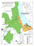
Transcription of ^ Pachaug State Forest - Connecticut
1 !!!!!!!!!!!!!!!!!!!!!!!!!!!!!!!!!!!!!!!! !!!!!!!!!!!!!!!!!!!!!!!!!!!!!!!!!!!!!!!! !!!!!!!!!!!!!!!!!!!!!!!!!!!!!!!!!!!!!!!! !!!!"""""""""""""""""""""""""""""""""""" """""""XWXWXWXWXWXWXWXWXWXWXWXWXWXWXWXWX WXWXWXWXWXWXWXWXWXWXWXWXWXWXWXWXWXWXWXWX WXWXWXWXWXWXWXWXWXWXWXWXWXWXWXWXWXWXWXWX WXWXWXWXWXWXWXWXWXWXWXWXWXWXWXWXWXWXWXWX WXWXWXWXWXWXWXWXWXWXWXWXWXWXWXWXWXWXWXWX WXWXWXWXWXWXWXWXWXWXWXWXWXWXWXWXWXWXWXWX WXWXWXWXWXWXWXWXWXWXWXWXWXWXWXWXWXWXWXWX WXWXWXWXWXWXWXWXWXWXWXWXWXWXWXWXWXWXWXWX WXWXWXWXWXWXWXWXWXWXWXWXWXWXWXWXWXWXWXWX WXWXWXWXWXWXWXWXWXWXWXWXWXWXWXWXWXWXWXWX WXW!1^_( )B4949138201138165 Lester RdStone Hill RdHe ll Hollow RdSp auldin g RdFlat Ro ck RdGard ner RdStone Hill RdKa te Downing RdPra tt RdTra il 1 RdTra il 1 RdBre akneck Hill RdLaweren ce RdTra il 2 RdTra il 2 RdTra il 2 RdCu toff RdTra il 1 RdFireto we r RdBeachdalePondWelchPondSawmillPondHellH ollowPondStoneHillReservoirLockesMeadowP ondDouglasPondMt Misery B kPachaug RiverPachaugPondGriswoldVoluntownPlainfi eldSterling^_^_^_^_^_^_^_^_^_^_^_^_^_^_^ _^_^_^_^_^_^_^_!
2 J![!j!j!5!5!j! !j!\!j! !S!j!5!l!y!@!@!j!j! (1 .30)B(0 .83)B(0 .86)B(0 .40)B(1 .14)B(0 .60)BR(1 .20)B(0 .90)B(1 .25)B(1 .38)B(0 .90)B(0 .70)B(0 .66)B(0 .83)B(0 .90)B(0 .50)B(1 .18)B^_(1 .15)B(0 .89)Y(0 .75)BR(0 .51)B(2 .00)BQuinnebaugTrailPachaugTrailQuinneba ugTrailPachaugTrailNehanti cTrailPachaugTrailNehanti cTrailNehanti c/PachaugTrailNehanti cTrail(0 .56)BPachaug State Forest :Griswold , Pl ain fie ld ,& Volu ntown, Connec tic sThe boundaries ofState-owned propertiesas sh own on this mapare approxi necticut Depar tment ofEnvironmental ProtectionBureau of Outdoor RecreationState Parks DivisionTrail distances between marks ( ) are in miles.^_Funding provided by th e Federal Highways Admi nsitr ati onRecreati onal Trails Grants Pr ogram admi niste red by th e Connecti cut Department of Environmenta l Pr ote cti on (D EP).]
3 The Blue, Blue/Red, White and Yellowblazed trails are foot travel Pachaug M ultiuse trail is open to registeredoff highway motorcycles; in addition to hikers,mountain bikers, and equestrian Pachaug Snowmobile trail is open tosnowmobiles in season; in addition to hikers,mountain bikers, and equestrian ![!j!5 TrailsParking Area! !y! !9!l!@!\Picnic AreaScenic ViewFrog HollowEquestrianCamping AreaCamping AreaPark OfficeYouth GroupCamping AreaBeachdale PondBoat LaunchHandicappedFishing PlatformRhododendronSantuary!SMt MiseryElev 441 FtPachaug StateForestHopeville PondState ParkGravel RoadBlue (B)Nehantic TrailPachaug TrailQuinnebaug TrailAs NotedBlue/Red (BR) Pachaug /QuinnebaugNehantic/Quinnebau gCrossover TrailsYellow (Y) Pachaug /QuinnebaugCrossover trail !!! Pachaug MultiuseTrail!1 Backpack CampShelter"""PachaugSnowmobile trail !]
4 Sports FieldXWXWXWCT Horse CouncilRecommended TrailThe Yellow Diamond Trails are theCT Horse Council's suggested Date - July 22, 2009
