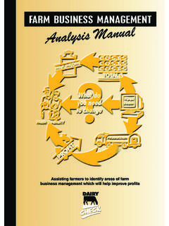
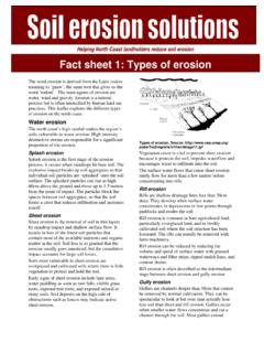
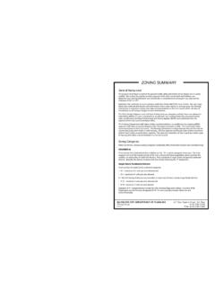
Transcription of Port Stephens - Great Lakes Marine Park Zoning Map
1 !!!!!!!!!!!!!!!!!!!!!!!!!!!!!!!!!!!!!!!! !!!!!!!!!!!!!!!!!!!!!!!!#*##*40 metre depth contour HABITAT PROTECTION ZONE iFIONA BEACH FIONA BEACH SANCTUARY ZONE Lighthouse Beach 3 nautical miles l3 Treachery Beach nautne of sicail mght from Little Gibber across Inner Rock and North Rock i50 metres les line of sight from Little Gibber our metdeptl hitcon ne re40 3 nautical miles offshore Limit of state waters r ouoftno c hstpeid gerthem t04 40 metre depth contour e rfoo hrsff oms s reeLtliittmawl elae ta ciattus fno 3timiLGibber km km km Port Stephens Great Lakes Marine Park Zoning Map 012345 Nautical Miles 0 2 4 6 810 Kilometres Map Projection: Unprojected Geographic. Horizontal Datum: Geodetic Datum of Australia (GDA94) 1:130,000 @ A1. Produced by DPI Fisheries, Aquatic Environment July 2019. Imagery provided by nearmap 2019.
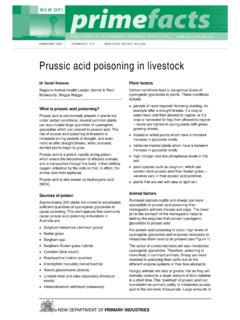
2 State of New South Wales through Department of Planning, Industry & Environment 2019. NSW waters Commonwealth waters Sanctuary Zone Hunter Marine Park Sanctuary Zone (Speed Restriction 4 knots) Recreational fishing is permitted. See user guide for more Protection Zone Habitat Protection Zone (Restrictions Apply)* General Use Zone General Use Zone (Seasonal Commercial Closure) Special Purpose Zone Sanctuary Zone Marker Navigation Markers (Selected Areas Only) Boat Ramp Habitat GeneralSanctuaryActivity Protection UseZone Zone Zone Recreational fishing Line fishing * Spearfishing * Trapping * Bait collection * Nets (scissor, hand hauled, scoop, landing, hoop) * Collecting Recreational shell collecting *2 *2 Collecting for aquariums - commercial and private P* P Recreational seaweed collection *2 2 Non-Extractive Recreational Activities Navigation of vessels SCUBA diving and snorkelling 3 3 3 Motorised water-sports 4 Hovercraft, airboat and seaplane PPP Domesticated animals 5 5 5 Competitions Line and spearfishing P* P Other (non-extractive) PPP Other Activities Aquaculture P1 1 Anchoring 6 Organised sporting or other activity PPP Research PPP Commercial Tourist Activities Commercial tour operators (non-extractive)
3 PPP Charter fishing PP*1 P Commercial Fishing Fish and prawn trawling 7 Beach hauling/purse seine/lift net 8 Line fishing * Fish and lobster trapping * Hand gathering * Longline/setline/dropline Estuary prawn netting 9 10 Estuary - mesh and haul netting Crab and eel trapping * A summary of activities permitted and restrictions that apply are detailed above. Refer to theuser guide for further information or the Marine Estate Management (Management Rules) Regulation 1999 for full details. Note:All other relevant legislation continues to apply in addition to the management rules. Land based line fishing is the only method of fishing p mitted in the Little Beach Habitat* Protection Zone. Fishing is only permitted from the wheelchair access jetty, the Little Beach Jetty and the beach between these collecting in the Dutchmans Beach Habitat Protection Zone.
4 Cabbage Tree Island Habitat Protection Zone is restricted to the taking of yellowtail scad, slimy mackerel and garfish only. No fishing with bait in the Broughton Island, Sawtooth and Edith Breaker Habitat Protection Zones. Shore based recreational line fishing is the only method permitted in the Fiona Beach and Cellito South Habitat Protection Zones. No fishing from anchored vessels in Broughton Island and Sawtooth Habitat Protection Zones. Recreational trolling only permitted in the stippled Open Ocean restricted habitat zone (ofshore Broughton Island ) from 1 December to 30 April (inclusive) each year. No fishing from anchored or drifting vessels (trolling only) and no fishing pe mitted outside specified timeframe. Activity is permitted in the zone Activity is not permitted in the zone P Marine parks permit required 1 Requires licence/lease under the Fisheries Management Act 1994, and is subject to the provisions of the management plan 2 Restrictions apply.
5 Daily possession limit of 5 shells of any one species and 20 litres of seaweed. No collecting at Little Beach, Dutchmans Beach or Cabbage Tree Island habitat protection zones. 3 Restrictions apply in greynurse shark critical habitats. Refer to user guide for further information 4 Permissible in Smiths Lake and Boolambayte Lake sanctuary zones, and (by permit) in the Fly Point Corrie Island sanctuary zone 5 Subject to restrictions refer to user guide 6 Not permissible to anchor on seagrass in sanctuary zones 7 Fish trawling and prawn trawling are not permitted in estuaries, Lakes and rivers 8 Permissible only at designated locations. Refer to user guide 9 Permissible only in Smiths Lake habitat protection zone and Myall River Camp habitat protection zone 10 Bombah Broad water annual seasonal commercial netting closure between 1 May and 31 August (inclusive)
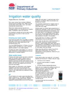
6 In any year THIS MAP IS NOT TO BE USED FOR NAVIGATION 151 55'E 152 0'E 152 5'E 152 10'E 152 15'E 152 20'E 152 25'E 152 30'E 152 35'E FORSTER Cape Hawke SLSC 'E 152 'E t CapeHawke 152 'E 32 'S Lati udeRock 32 'S 32 'S Inset E Sanctuary zone extends to tidal limit of creek Inset F 0 250 500 Inset G 0 250 500 Inset H 0 50 100 metres metres metres Salamander Bay FLY POINT - CORRIE ISLANDSANCTUARY ZONE Nanabah Creek FAME COVESANCTUARY ZONE 152 ' E 152 ' E #* #* SALAMANDER BAYSANCTUARY ZONE 152 ' E 152 ' E 32 ' S 152 ' E ##* * Little Nelson Bay Fame Cove Piggys Beach One Tree Boondaba IslandIsland 152 ' EPINDIMARSANCTUARY ZONE MALLABULLASANCTUARY ZONE MamboWetlands MallabullaPoi tn 32 ' S Little BeachMarina No fishingfrom beach north of jetty p Land based line fishing is the onlymethod of fishing permitted in theLittle Beach Habitat ProtectionZone.
7 Fishing is permitted fromthe wheelchair access jetty, theLittle Beach jetty, and the beachbetween these jetties. No berleying. Little BeachJett y 0 500 1000 metres WheelchairAccess Jetty Sanctuary zone extends totidal limit of creek The BranchRiver Little SwanBay DaviPo sint Inset J 0 500 1000 metres LITTLE BRANCHSANCTUARY CREEKZONE Little BranchCreek Sanctuary zone extends to 0 500 1000 tidal limit of creek metres OrobillahIsland Big SwanBay Inset K0 500 1000 metres SnapperIsland LITTLE SWAN BAYSANCTUARY ZONE BULAHDELAH Sanctuary zone extends totidal limit of creek MayersBay SwanPoint RussellBay s Myall Lake LongPoint CorriBaygans KatawayBay see Inset A Sanctuary zone extends totidal limit of river Cut FeetIsland Corrie Island FLY POINT - CORRIE ISLANDSANCTUARY ZONE Winda Woppa BarnesRocks JIMMYS BEACHSANCTUARY ZONE Two MilLake e BoolambayteLake MungoBeach ALLWORTH The BranchRiverKaruahRiver 4 Bombah Broadwater NumberBeachOne Inset A THE
8 PINNACLESANCTUARY ZONEJ anies 32 'SCorner 32 'S 152 'E SevenMileBeach 152 'E 32 'S 32 'S Wallis Lake 32 50'S 32 45'S 32 40'S 32 35'S 32 30'S 32 25'S 32 20'S 32 15'S 152 'E 152 'E #* #* Inset I Inset B North RockInner Rock 32 ' S32 ' S 32 ' S 32 ' S Charlott 32 20'SHead e Boomerang Beach PACIFIC PALMS Blueys Beach SMITHS pSANCTUARYLAKEZONE SMITHSMYALL LAKE Bi # LAKE Cellito Beach* SANCTUARY ZONE 1 Poignt Smiths Lake #* p Sandbar Beach 32 'S#* #* CELLITO SOUTHTATpMYALLSANCTUARYLAKE3 ZONE HABI PROTECTIONti #* Shore based recreais permitted. No o or coll ZONE t ecting onal line fishingher t fishingis aype ofllowed. Boolambayte #*Creek BOOLAMBAYTE # #**SANCTUARY LAKEZONE 32 'ESkeleton Rocks CELLITO SOUTHSANCTUARY ZONE 'S MyallRiver pMYALL LAKE Sugarloaf PointSANCTUARY ZONE 2 32 'S 'E Pi Shore based recreational line fishing permit other t ti is allowedPogeonint except ype of fishing or collecicki for commerc t p#* #* #* hand p ngbetween high and ltitude 152 152 ngial #p and la* t purposes ow water'E 152 GYagon Treacheryibber 152 'E 32 'S 'E BiGgibber SealRocks Edith Breaker(submerged) 152 'E SEAL ROCKSSANCTUARY ZONE 32 'S !
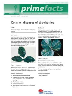
9 !! !! !!! !! #* !!! !! !!! !! #* #* Bombah Point pKARUAH RIVERSANCTUARY ZONE 152 'E 152 'E 152 'E 152 'E 32 'S 32 'S 32 'S 152 'E Nerong BOMBAH BROADWATERC reek SANCTUARY ZONE ##** SPotonyint p p 152 'E 32 'S 152 'E 152 'E BagnallBeachs No collecting invertebratby hand picki es NelsonHead Boat Beach Fl LittlePoiyn Beach pBrasswater #** tng. DutchmansBeach Nelson Bay Marisee Inset I LittleGibberll na MyaRiver Limeburners Creek Sanctuary zone extends totidal limit of creek Broughton Island 32 'E p ' E res Sawtoot 32 ' SRocks h 152500met 32 ' S SEAL ROCKSSANCTUARY ZONE 'S Sanctuary zone extends totidal limit of creek Reedy Creek KARUAH Sanctuary zone extends ttidal limit of creek *MYALL RIVER # Hab Open OceanSANCTUARY ZONE itat Protection ZoneRecreational trolling onlyNORTH ARM permitted from 1 DecemberSANCTUARY COVE to 30 April (inclusive) in any No fishing from#* anchored or driftingvessels at all times.
10 NUMBER ONE #p *SANCTUARY COVE # TEAZONE * GARDENS32 'S p p 32 'S KoreKoreCreekSanctuary zone extendstidal limit of creek to YalimbahCreek Bundabah Inset BCreek o WiI BUNDABAH Edith Breaker(submerged)NORTH rrungsland ARMCOVE Pindisee Inset K Twelve MilCreek e marBayLittle Swan JiBay p p HAWKSNEST p pLITTLE SWANSANCTUARY BAYZONE see ProvidenceBay seeInset C mmysBeach BennetBeachst 152 'E !! Air Salt Ash Weapons Range see Restricted Area see Inset J Inset G # #** Cabbage Tree Island ! !!! !!! !! *see Inset E # Yacaaba !!! !!! !!!p Head Little Island!!! !!! !!! !P o r t S t e p h e n s TomareeHead Boondelbah Island see 32 41'S SOLDIPO ERSINT Inset H RookesTanilba PointBig Swan Point MallabullaBay #* #* #* #* CROMARTYS seeBAYSANCTUARYpp #* #* pLEMON TREETANI ZONEBAYLBA PASSAGE Inset F CORLETTE NELSON SHOALBAY BAY p Zenith BeachIDsee nsetWreck Beach ProvPoidenceint 152 ' E S Taylors Beach Fishing for bait only(Yellowtail scad,slimy mackerelSanctuary zone extends to and garfish).