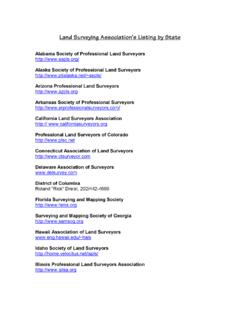
Transcription of Professional Land Surveyor
1 Professional land Surveyor Professional land Surveyors establish official land , air space, and water boundaries. They write descriptions of land for deeds, leases, and other legal documents; define air space for airports; and measure construction and mineral sites. Surveyors also provide data relevant to the shape, contour, location, elevation, or dimension of land or land features. Surveying technicians assist Professional land Surveyors by operating survey instruments and collecting information in the field, and by performing computations and computer- aided drafting in offices. Mapping technicians calculate mapmaking information from field notes. They also draw topographical maps and verify their accuracy. Professional land Surveyors manage survey parties who measure distances, directions, and angles between points and elevations of points, lines, and contours on, above, and below the earth's surface.
2 They plan the fieldwork, select known survey reference points, and determine the precise location of important features in the survey area. Surveyors research legal records, look for evidence of previous boundaries, and analyze the data to determine the location of boundary lines. They also record the results of the survey, verify the accuracy of data, and prepare plots, maps, and reports. Surveyors who establish boundaries must be licensed by the State in which they work, and are known as Professional land Surveyors. Professional land Surveyors are sometimes called to provide expert testimony in court cases concerning surveying matters. A survey party gathers the information needed by the Professional land Surveyor . A. typical survey party consists of a party chief and one or more surveying technicians and helpers.
3 The party chief, who may be either a Professional land Surveyor or a senior surveying technician, leads day- to-day work activities. Surveying technicians assist the party chief by adjusting and operating surveying instruments, such as the theodolite (used to measure horizontal and vertical angles), electronic distance-measuring equipment and levels to determine elevations. Surveying technicians or assistants position and hold the vertical rods, or targets, that the theodolite operator sights on to measure angles, distances, or elevations. They also may hold measuring tapes, if electronic distance-measuring equipment is not used. Surveying technicians compile notes, make sketches, and enter the data obtained from surveying instruments into computers. Survey parties may include laborers or helpers who perform less-skilled duties, such as clearing brush from sight lines, driving stakes, or carrying equipment.
4 For larger projects, surveyors are increasingly using the Global Positioning System (GPS), a satellite system that precisely locates points on the earth by using radio signals transmitted via satellites. To use this system, a Surveyor places a satellite signal receiver, a small instrument mounted on a tripod, on a desired point. The receiver simultaneously collects information from several satellites to establish a precise position. Surveyors then interpret and check the results produced by the new technology. The receiver also can be placed in a vehicle for tracing out road systems. Because receivers now come in different sizes and shapes and the cost of the receivers has fallen, much more surveying work is being done using GPS. Some surveyors perform specialized functions that are closer to those of a cartographer than to those of a traditional Surveyor .
5 For example, geodetic surveyors use high-accuracy techniques, including satellite observations (remote sensing), to measure large areas of the earth's surface. Geophysical prospecting surveyors mark sites for subsurface exploration, usually petroleum related. Marine or hydrographic surveyors survey harbors, rivers, and other bodies of water to determine shorelines, topography of the bottom, water depth, and other features. In some States photogrammetrists are required to be licensed as Professional land Surveyors. The work of surveyors and cartographers is changing because of advancements in technology. These advancements include not only the GPS, but also new earth resources data satellites, improved aerial photography, and geographic information systems (GIS) which are computerized data banks of spatial data.
6 The Geographic Information Specialist combines some functions of mapping science and surveying into a broader field concerned with the collection and analysis of geographic information. Working Conditions Surveyors usually work an 8-hour day, 5 days a week, and may spend a lot of time outdoors. Sometimes they work longer hours during the summer, when weather and light conditions are most suitable for fieldwork. Seasonal demands for longer hours are related to demand for specific surveying services. Home purchases are traditionally related to the start and end of the school year; construction is related to the materials to be used such as concrete and asphalt are restricted by outside temperatures. Professional land Surveyors and technicians engage in active, and sometimes strenuous, work. They often stand for long periods, walk considerable distances, and climb hills with heavy packs of instruments and other equipment.
7 They can also be exposed to all types of weather. Traveling often is part of the job; they may commute long distances, stay overnight, or temporarily relocate near a survey site. Surveyors can spend considerable time indoors planning surveys, analyzing data, and preparing reports and maps. Employment Major Federal Government employers are the Geological Survey (USGS), the Bureau of land Management (BLM), the Army Corps of Engineers, the Forest Service (USFS), the National Oceanic and Atmospheric Administration (NOAA), the National Imagery and Mapping Agency (NIMA), and the Federal Emergency Management Agency (FEMA). Most surveyors in State and local government work for highway departments and urban planning and redevelopment agencies. Construction firms, mining and oil and gas extraction companies, and public utilities also employ surveyors and surveying technicians.
8 Training, Other Qualifications, and Advancement Most people prepare for a career as a Professional land Surveyor by combining postsecondary school courses in surveying with extensive on-the-job training. However, as technology advances, a 4-year college degree is becoming more of a prerequisite. About 25 universities now offer 4-year programs leading to a degree in surveying. Junior and community colleges, technical institutes, and vocational schools offer 1, 2, and 3-year programs in both surveying and surveying technology. All 50 States and all territories (Puerto Rico, Guam, Marianna Islands, and Virgin Islands) license Professional land Surveyors. For licensure, most State licensing boards require that individuals pass a written examination given by the National Council of Examiners for Engineering and Surveying.
9 Most States also require that surveyors pass a written examination prepared by the State licensing board. In addition, they must meet varying standards of formal education and work experience in the field. In the past, many individuals started as members of survey crews and worked their way up to become licensed surveyors with little formal training in surveying. However, because of advancing technology and rising licensing standards, formal education requirements are increasing. At present, most States require some formal post-high school coursework and 10 to 12 years of surveying experience to gain licensure. However, requirements vary among States. Generally, the quickest route to licensure is a combination of 4 years of college, 2 to 4 years of experience (a few States do not require any), and passing the licensing examinations.
10 An increasing number of States require a bachelor's degree in surveying or in a closely related field, such as civil engineering or forestry (with courses in surveying), regardless of the number of years of experience. High school students interested in surveying should take courses in algebra, geometry, trigonometry, drafting, mechanical drawing, and computer science. High school graduates with no formal training in surveying usually start as apprentices. Beginners with postsecondary school training in surveying usually can start as technicians or assistants. With on-the-job experience and formal training in surveying either in an institutional program or from a correspondence school workers may advance to senior survey technician, then to party chief, and in some cases, to licensed Surveyor (depending on State licensing requirements) The National Society of Professional Surveyors (NSPS), a member organization of the American Congress on Surveying and Mapping (ACSM), has a voluntary certification program for called Certified Survey Technician.