Transcription of PROJECT Draw a cross-section - jaconline.com.au
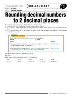
1 draw a cross - section John Wiley & Sons Australia, Ltd (Page 1 of 2) cross - section shows the shape of a feature (such as a mountain) viewed from the side, as if cut through with a are constructed using the contour lines on a topographic map. (You may like to refresh your memoryabout topographic maps by reading the information box on page 2 of this worksheet.)In this worksheet, you will draw two cross -sections from the topographical map of Mt Etna included on page 3. (Youmay find it easier to draw these if you first enlarge the map on a photocopier.) On completion, explain in a couple ofparagraphs any similarities and differences in the two cross -sections, and what this tells you about the terrain in eachcase.
2 Your cross -sections will be drawn between: grid reference 227033 (name it A) and grid reference 252047 (name it B) grid reference 239054 (name it C) and grid reference 241026 (name it D).In each case you will start and finish on a contour line. This will mean making a very minor adjustment for your startand finish points, once you have pinpointedyour grid following example is provided to remindyou how to draw a a cross -section1. Line up the edge of a piece of plain paperalong the line marked Make a small vertical mark on your paperwhere each contour line meets it.
3 Alsodraw small marks below X and Y and labelthem X and Y. Near each vertical mark,write the height of the contour. (Use thecontour interval to help you work this out.)3. Line up your marked-up piece of paperagainst a graph you have drawn. Yourgraph should be exactly the same widthas the length of the line between X andY. Line up the X with the vertical axis ofyour graph. For each vertical mark on yourpiece of paper make a corresponding doton your graph (to record the height of thecontour above sea level).4. Join the dots to create your first 18 have been plotted for Give your cross - section a title.
4 If you wish,you could shade the area under the line,so that the shape of your completedcross- section is by MAPgraphics Pty Ltd, Brisbane John Wiley & Sons Australia, Ltd (Page 2 of 2) mapsTopographic maps show the relief (height andshape) of the land using contours. They alsoshow physical features such as forests, riversand lakes and human-made features such asroads, railways and settlements. The key on atopographic map uses conventional signs toshow the major linesContour lines are superimposed on topographicmaps. These are numbered lines that join placesof equal height above sea level on a show the height, shape and location ofhills and mountains in a landscape.
5 Thedifference in height between one contour lineand the next is always the same. This is knownas the contour any contour map, evenly spaced contoursmean an even slope, close contours mean asteeper slope and widely spaced contours meana gentle slope or flat area. Spot heights are alsogiven to show the actual height of particularlocations. The highest points of a region areusually shown with spot on a topographic mapA square grid is superimposed on topographicmaps. These grids are numbered with two-digitnumbers on the map s margins. Lines that runup and down the map (north/south) are calledeastings, because the numbers increase as youmove east.
6 The lines running across the map(east/west) are called northings because thenumbers increase as you move north. Eastingand northing numbers can be put together toform a four-figure grid reference the eastingis always given first ( 2304).Four- and six-figure grid referencesThe four-figure area reference will tell you thegrid square in which a feature will be found. Topinpoint a more precise location of a feature, asix-figure grid reference is required. To work out the six-figure grid reference of a particular point on a map, you need to imagine thatthe distance between two eastings and two northings can be divided into 10 equal segments (tenths).
7 These imaginary lines divide thespaces between one easting and the next into 10 equal columns, and the spaces between one northing and the next into 10 equal rowsBy way of example, an extract from the Mount Etna topographic map has been included above. You will note that the point to beidentified (X) lies in the grid formed by eastings 23 and 24 and northings 04 and 05. Estimate on which imaginary lines between thesetwo eastings and two northings this point is located. This will give you the third and sixth numbers respectively for your six-figuregrid reference ( 236046).
8 Reference:SOSE Alive 3, pp. 108 9 SOSE Alive Geography 2, pp. 12 13 This six-figure grid reference of point X is 23 6 04 6 From the eastings From the northingsThat is: 2360462005001000150020002500300077944532 5852103938017731734218214823323293429422 4141345284712841398160316328221545839678 09163297312731010131674213042623822640 Monte CalcinieraMonte CrisimoMonte PizzilloMonte MinardoMonte PinitedduMonte EtnaMonte ScorsonePATERNOBELPASSOBIANCAVILLAADRANO BRONTEGIARRERIPOSTOACIREALECATANIAMISTER BIANCORANDAZZOS anta MariaMalettoPassopisciaroLinguaglossaNun ziataMascaliSanta VenerinaSan TeclaAci SeneAntonioStazzoPedaraMascaluciaSan PietroClarenzaSan GiovanniGravina diCataniaTrecastagniAci PlataniAci TrezzaAci
9 CastelloNicolosiZafferanaEtnea2223242526 2223242526051015 kilometresScale 1:250 000 Highway or FreewayMajor roadMinor roadTracksRailwayBuilt-up areaSmall built-up area or buildingsIndex contour line with height in metresContour interval 100 metresSpot height in metresMedium or dense forest Lava flow1398500 Contour line 0203040502030405 PalermoSiracusaMessinaMEDITERRANEAN SEAS icilyNCATANIAMt Etna 3323 mBAMap by MAPgraphics Pty Ltd, Brisba