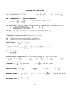
Transcription of RADAR HORIZON / LINE OF SIGHT
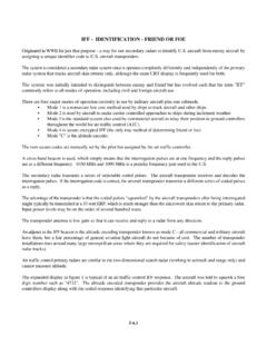
1 GROUND CLUTTERWEATHER CLUTTERINTERFERENCERADAR HORIZONSHADOWINGhFEETRNAUTICAL MILESHFEETANTENNAHEIGHTPOINT "H"H = ( h)2500040003000200010,000100050020010050 025020015010050010,000500040003000200010 000500200100502525250200150100500hHSHADO WRRNM' ' 1. RADAR HORIZON and ShadowingFigure 2. Earth Curvature NomographRADAR HORIZON / LINE OF SIGHTT here are limits to the reach of radarsignals. At the frequencies normally used forradar, radio waves usually travel in a straightline. The waves may be obstructed byweather or shadowing, and interference maycome from other aircraft or from reflectionsfrom ground objects (Figure 1).As also shown in Figure 1, anaircraft may not be detected because it isbelow the RADAR line which is tangent to theearths rules of thumb are:Range (to HORIZON ):Range (beyond HORIZON / over earthcurvature):In obtaining the RADAR HORIZON equations, it is common practice to assume a value for the Earth's radius that is 4/3 times theactual radius.
2 This is done toaccount for the effect of theatmosphere on RADAR a true line of SIGHT , such as usedfor optical search and rescue, theconstant in the equations changesfrom to nomograph fordetermining maximum target rangeis depicted in Figure 2. Although anaircraft is shown to the left, it couldjust as well be a ship, with radars ona mast of height "h". Any target ofheight (or altitude) "H" is depictedon the right also Section 5-1 onducting and refraction, which mayincrease range beyond k ft20 k ft30 k ft40 k ftTARGET ALTITUDE (k feet) RADAR AIRCRAFT ALTITUDE01020304050607080901001211109876 54 ANTENNA HEIGHT (feet)RNM' (NM)' (NM)' (NM)' 3. Aircraft RADAR vs Aircraft Target Maximum RangeFigure 4. Ships RADAR HORIZON with Target on the SurfaceThis data was expandedin Figure 3 to consider themaximum range one aircraft candetect another aircraft using: (with h in feet)It can be used for surfacetargets if H = 0.
3 It should betargetnoted that most aircraft radars arelimited in power output, andwould not detect small or surfaceobjects at the listed general rules of thumb for surface "targets/radars" are:For Visual SAR:For ESM:Figure 4 depictsthe maximum range that aship height antenna candetect a zero height object( rowboat etc).In this case "H" = 0, andthe general equationbecomes:Where h is the height ofrthe RADAR in feet.