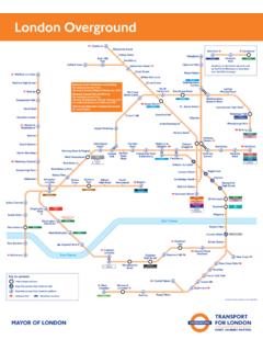
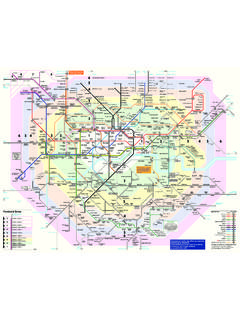
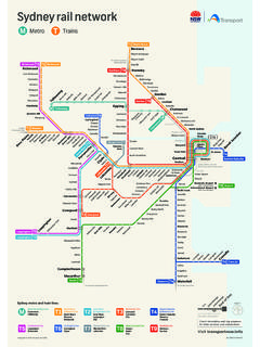
Transcription of RAIL MAP 1 Cheshire County Rail Network Map
1 MMMMMMMMMMMMMMMMMMMQ ueensferryMoldNorthopEwloeBroughtonKinne rtonConnah s QuayManchesterInternationalAirportMChest er City rail LinkFree Bus Link betweek ChesterRailway Station & City Centre 0 1 2 3 4 5 6 7 8 Kilometres0 1 2 3 4 5 MilesProduced & designed by Cheshire County Council / Transport Co-ordination / Publicity DepartmentnonooMMMMMMMMMMMMMMMMMMMMMMMMM MMMMMMMMMMMMMMMMMMMMMMMMMMMMMMMMMMMMMMMM MMC heshire OaksChester ZooGreatSuttonWIRRALMERSEYSIDEMERSEYSIDE HALTONWARRINGTONFLINTSHIREWREXHAMSTAFFOR DSHIRESTAFFORDSHIREDERBYSHIREDERBYSHIREG REATERMANCHESTERGREATERMANCHESTERGREATER MANCHESTERN eston/Parkgate Area MapEllesmere Park Area MapChester Area MapNorthwich Area MapWinsford Area MapMiddlewich Area MapKnutsford Area MapWilmslow Area MapPoynton Area MapMacclesfield Area MapCongleton Area MapKey & Notes to MapMain rail /Interchange Station(Station with Main Long Distance & localservices & full passenger andinterchange facilities).
2 Local/ Network Stations.(Stations with local Network services)Stations within the Merseyside PTE(Merseytravel) Network within the GMPTE (GreaterManchester PTE) Network Tram Network StationsStations where all platforms are accessablewithout having to use any steps/Staffavailable to helpCity/Large TownTown/VillagePlace of InterestAirport connectionCheshire borderTrain operating companies/web addressArriva Trains Trains Express Trains Alsager Area MapSandbach Area MapCrewe Area MapNantwich Area MapChesterBacheCapenhurstBromboroughSpit alPort SunlightWest KirbyBebingtonRock FerryBromboroughRakeHootonStanlow &ThorntonEllesmerePortOverpoolInce & EltonMouldsworthDelamereCuddingtonActon BridgeGreenbankHartfordNorthwichPlumleyW insfordSandbachHolmes ChapelGoostreyChelfordPrestburyAdlington PoyntonBramhallDavenportWoodsmoorHazel
3 GroveMiddlewoodDisleyDoveHolesChapel-en- le-FrithBuxtonWhaleyBridgeFurnessValeNew MillsNewtwnStyalHandforthCheadleHulmeGat leyEast DidsburyBurnageLevenshulmeBrinningtonBre dburyRomileyMarpleStrinesRose HillNew Mills CentralChinleyGortonFairfieldGuide BridgeAshtonStalybridgeHyde CentralWoodleyNewton for HydeGodleyHattersleyBroadbottomDintingHa dfieldGlossopReddishNorthHeatonChapelMau ldeth RdHealdGreenAlderleyEdgeMobberleyAshleyH aleNavigationRoadAltrinchamInterchangeKn utsfordLostockGralamHelsbyFrodshamRuncor n EastRuncornLittle SuttonEasthamRakeGreen LaneBirkenheadCentralHoylakeManor RoadMeolsMoretonLeasoweBidstonWallasey VillageWallasey Grove RoadNew BrightonBirkenheadNorthBirkrnheadParkCon way ParkHamiltonSquareMoorfieldsJamesStreetC entralAigburthBrunswickSt MichaelsHunts CrossHalewoodBroadGreenRobyHuytonWavertr ee TechnologyParkWhistonPrescotEcclestone ParkThalto HeathSt HelensCentralGarswoodRainhillLea GreenEarlestownNewton-le-WillowsSt HelensJunctionCressingtonWest AllertonLiverpoolSouth ParkwayHoughGreenWidnesSankey forPenkethPadgateBirchwoodGlazebrookIrla mFlixtonUrmstonChassenRdEcclesPatricroft EcclesLadywellWeasteLangworthyTrafford BarA-BroadwayB-Harbour CityC-AnchorageD-Salford QuaysE-Exchange QuayF-Pomona1 Shudhill2 Market St3 Piccadilly Gds4 Mossley St5 St Prters Square6 G Mex7 DeansgateCornbrookDane RoadStretfordBrooklandsSaleTimperleyOld Trafford(for Man Utd FC/LCCC)
4 HumphreyParkTraffordParkManchester VictoriaManchesterOxford RoadManchester PiccadillyWarringtonCentralMossleyHillSa ndhillsKirkdaleBootle Oriel RdBank HallRice LaneOrrell PkWaltonFazakerleyBootle New StrandEdgeHillLiverpoolLime StreetWarringtonBank QuayCreweWilmslowStockportManchesterAirp ortMacclesfieldStoke-on-TrentUptonHeswal lNestonHawarden BridgeShottonFlintHawardenBuckleyPenyffo rddNantwichAlsagerKidsgroveCongletonLong portLongtonWrenburyWhitchurchHopeCaergwr leCefn-y-BeddGwersylltWrexham GeneralRuabonWrexham Central123456810111213141597 ABCDEF8 Salford Crescent9 Salford Central10 Ardwick11 Ashburys12 Belle View13 Ryder Brow 14 Hyde North15 Flowery Field HeswallWillastonNestonArrowe ParkHospitalGreasbyParkgateFfordd LlanarthNess GardensChester CastleCity WallsGrosvenor MuseumMilitary MuseumRoman AmphitheatreRoodee RacecourseThe RowsWest Park Museum& Art GalleryParadise Silk MillStyal Country ParkQuarry Bank MillWaterways MuseumDeeside Leisue CentreAlbert DockDental Hospital MuseumLiverpool CathedralLiverpool MuseumMerseyside Maritime MuseumMuseum of Labour HistoryLiverpool Tate GalleryWalker Art GalleryKnowsleySafari ParkDelamere ForestJodrell BankRadio TelescopeStapeley Water GardensCastlefielfds CentreCity Art Gallery G-Mex CentreHeaton Park & HallManchester MuseumMuseum of Sciemce & IndustrySalford QuaysWitworth Art GalleryLadyLeaverArt
5 GalleryBurtonBlaconChristletonSaltneyChe sterBusinessParkMickle TraffordInceGuildenSuttonWavertonTarporl eySpurstowRavensmoorNorburyAstonAshtonSu ttonWeaverStocktonHeathWaltonDaresburySt rettonWarburtonLymmHalebarnsBucklow HillCheadleStepping Hill HospitalHayfieldKettleshulmeCat & FiddlePott ShrigleyKerridgeLangleyLyme GreenWoodfordMottramMonksHeathEatonMowCo pMossleyBiddulphTunstallNewcastle-Under- LymeAlderleyParkMorleyGreenTableyAllosto ckCranageElworthHaslingtonWestonKeeleMad eleyHeathRode HeathArclidMiddlewichCledfordBridgeMobbe rleyLittleBollingtonAntrobusComberbachBa rntonAndertonWinchamRudheathDavenhamWins ford Ind EstCoppenhallWistastonShavingtonHankelow AudlemMinshullVernonChurchMinshullLatchf ordHighLeighKingsleyDelamereLittleBudwor thWeaverhamDelamereParkDuttonWestonPoint WidnesTarvinKelsallRossettHoltFarndonChu rtonAldfordMiltonGreenTattenhallBroxtonC luttonBickertonBickertonShocklachMalpasN o Mans HeathHaltonBrowLiverpoolJohn LennonAirportNational rail toStafford/Rugby/LomdonBirmingham/South East/South WestNational rail toShrewsbury/CardiffNational rail toShrewsbury/BirminghamNational rail toRhyl/LlandudnoHolyheadNational rail toSouthportNational rail toOrmskirkNational rail toKirby (& Wigan)
6 National rail toWigan/PrestonNational rail toWigan/PrestonCarlisle/Glasgow/Scotland National rail to BoltonNational rail to Huddersfield/Leeds/YorkNational Railto SheffieldNational Railto Stafford/Birmingham/LondonNational Railto DerbyRail Network Map for Cheshire / August 2007 River MerseyRiver DeeMMThis map is based upon Ordnance Survey material with the permission of OrdnanceSurvey on behalf of the Controller of Her Majesty s Stationery Office c Crown reproduction infringes Crown copyright and may lead to prosecutionor civil County Council (OS Licence No LA100019582 2007)Produced & designed by Cheshire County Council/Transport Co-ordination/Publicity Ref no : Cheshire County Council rail Network MapPublic Transpot Maps & Guides are available for the highlightedareas indicated on this map, these include maps, details & listingsof all local bus and rail services.
7 There is also a Public Transport Map & guide all for local bus & rail services for Cheshire . For copies of these and also any local ornational Public Transport Travel Information please ring the Cheshire Traveline on:0871 200 22 33(calls from landlines cost 10p per minute)seven days a week 8am - 8pmRNID Typetalk 18001 0871 200 22 33email ; stoParDWCoarryyaQuyyneVuntStHIniddleewog erKHo