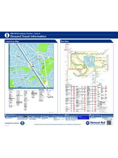
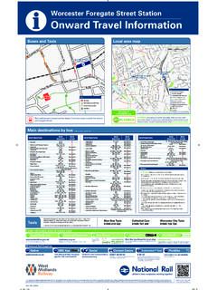
Transcription of Rainham (Essex) Station – Zone 6 Onward Travel …
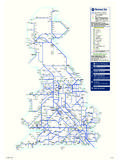
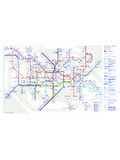
1 Onward Travel InformationiRainham (Essex) Station Zone 6 Local Area MapBus MapRoute finderDay busesBus route Towards Bus st ops 103 North Romford 165 Rainham Romford 287 Barking Rainham 372 hornchurch Lakeside Shopping Centre Destination Bus routes Bus stopsDestination finder Destination Bus routes Bus stopsDestination Bus routes Bus stopsAAveley Library 372 BBarkingr-on 287 pBarking London Road 287 pBecontree Heath Civic Centre 103 pBriscoe Road 165, 287 pC Chandlers Corner 165, 287 pCherry Tree Lane 165 p 273 Cr eekmouth Lodge Avenue Flyover 287 pD Dagenham Chequers Corner 287 pDagenham Eastr- 103 pDagenham Road 103 pE Eastern Avenue East Pet tits Lane 103 pElm Par kr-561 p 273 pEmerson Par kn 165 pGGidea Par k The Drill 165 pH Hall Road 372 hornchurch Abbs Cross Lane 165 372 pHornchurch Town Centre 372 p 165 pKKnightswood Estate 103 pL Lake Avenue 165.
2 287 pLakeside Shopping Centre 372 pLove Lane3 72 M Mardyke Estate 287 pLower Mardyke AvenueMill Road 372 Mungo Par k Road 165 p73 2 pN New Road Betterton Road, 287 pManor Way, Spencer Road, South Street and Thames AvenueNew Road Cherry Tree Lane 165, 287 p 273 pNorth Romford Chase Cross 103 pO Oldchurch Road 103 pfor Queens HospitalQQueens Hospital 103 pR Rainham Abbey Wood Lane 165, 287 pRainham Road 103 pRainham Road North 103 pRainham Road South 103 Ripple Road 287 pRomfordn301 p 561 pRomford Brewery 165 Romford Bus Garage 103 pRomford Mark et 103 p 561 pRush Green Road Dagenham Road 103 S Ship Lane Thurrock FC 372 pSouth End Road 165 p 273 pSouth hornchurch Cherry Tree 103 561 p 273 pT Thorn Lane 165, 287 pU Upminster Road North 165, 287 pUpminster Road South 165.
3 287 pW Wennington Green 372 ppWennington Road 372 ppKey r- Connections with London Undergr ound o Connections with London Over gr ound n Connections with National Rail142536 Red discs show the bus stop you need for your chosenbus service. The disc appears on the top of the bus stopin the street (see map of town centre in centre of diagram). rrWennington RoadFerro RoadWennington RoadBrook WayWennington RoadEastwood DriveWennington RoadEast Hall LaneWennington RoadKent ViewWennington GreenLakesideShopping CentreUpminster Road SouthRainham Village SchoolUpminster Road SouthBrights AvenueChandlers CornerUpminster Road NorthAllen RoadMill RoadSt Pauls CloseAveleyLibraryWennington RoadWennington Hall FarmLove LaneArnhem AvenueLove LaneCentral AvenueMill RoadHanford RoadShip LaneThurrock FCHall RoadThe ParadeHall RoadHall AvenueUpminster Road NorthKing Edward
4 AvenueUpminster Road NorthAcer AvenueLake AvenueThorn LaneBriscoe RoadRainhamAbbey Wood LaneRainham RoadKnightswood EstateSouth HornchurchCherry TreeRainham RoadNelson RoadRainham RoadFyfield RoadDagenham RoadThorogood WayDagenham RoadYork RoadRainham Road SouthDagenham EastRainham Road NorthBecontree HeathCivic CentreRush Green RoadDagenham RoadOldchurch Roadfor Queens HospitalRomfordRomfordMarketEastern Avenue EastPettits LaneRomford Bus GarageNorth RomfordChase CrossNew RoadCherry Tree LaneNew RoadManor WayCherry Tree LaneDunedin RoadCherry Tree LaneEdmund RoadCherry Tree LaneStanley Road SouthSouth End RoadAlexandra RoadSouth End RoadFord LaneMungo Park RoadSouth End RoadMungo Park RoadKingaby GardensMungo Park RoadFreeborne GardensElm ParkHornchurchAbbs Cross LaneHornchurchTown CentreEmerson ParkGidea ParkThe DrillNew RoadBetterton RoadNew RoadSpencer RoadNew RoadSouth StreetMardyke EstateLower Mardyke AvenueNew RoadThames AvenueDagenhamChequers CornerCreekmouthLodge Avenue FlyoverRipple RoadBarkingLondon
5 RoadBarkingRomfordBrewery372287165103165 372287 ROMFORDEMERSON PARKELM PARKSOUTHHORNCHURCHDAGENHAMBARKINGWENNIN GTONThe yellow tinted area includes ever ybus stop up to about one-and-a-half miles from Rainham . Main stops are shown in the white area ROADBRIDGE ROADWENNINGTON ROADBROADWAYUPMINSTER ROAD SOUTHVIKING WAYNEW ROADANGLESEY DRIVECREEKSIDELAMSON ROADCORNERDOVERSFGPRCBNMAKJHEDR ainhamSchool School TescoRainhamHall*Y ou pay no more than 5p per minute if calling from a BT landline. There may be a connection from mobiles or other landline providers may vary.
6 24 hour Travel information0843 222 1234*Transport for LondonMAYOR OF DR (HAV) TFL (T) Transport for London Information correct from September 2012 Buses from Rainham A B2 Anglesey Drive C1 Ashwood Avenue B B2 Bridge Road B2 Broadway C3 Brook Way C B2 Capstan Drive A1 Cherry Tree Lane C1 Cloister Close C2 Cowper Road A2 Creekside D B1 Dominion Way A1 Dunedin Road E C2 East Close C3 Elizabeth Road C2 Ellis Avenue A1 Evansdale S B2 St. Helens Court A3 Salamons Way C3 South Hall Drive C1 Stirling Close T C3 Thames Close B3 Thames Gateway U B2 Upminster Road South V C2 Venette Close B1 Viking Way W C1 Waverley Road B2 Wennington Road C2 West Close C3 Wilfred Avenue F C2 Ferro Road B3 Ferry Lane C2 Findon Gardens G A1 Gisborne Gardens C1 Glenwood Avenue H C1 Hawthorn Avenue I C2 Ingrebourne Road K B1 Kelburn Way L B2 Lamson Road C1 Leston Close M A1
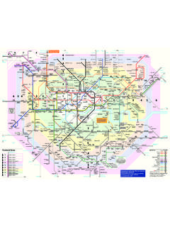
7 Manor Way C2 Martin Drive C2 Melville Road N B1 New Road B1 New Zealand Way P C2 Palliser Drive C2 Parkview Mews B2 Parkway C1 Penny Close A1 Philip Road C1 Pinewood Avenue Q B1 Queenstown Gardens R B1 Rainham Road C3 River Close C3 Rothbury Avenue B1 Albion, The B2 Bell, The B2 Creekside Park A1 Havering College Rainham Campus B1 La Salette Catholic Primary School B2 New Angel Inn C2 New Beginnings Day Nursery B2 Old Vicarage, The B1 Our Lady of Lane Salette RC Church B2 Rainham Hall B2 Rainham Hall Gardens B2 Rainham Library C2 Rainham Methodist Church B2 Rainham Parish Church B2 Rainham Social Club C1 Rainham Village Primary School C2 Rainham Working Men s Club B2 Royal Mail Enquiry Office B1 Tesco B2 Youth Centre Crown copyright and database rights 2016 Ordnance Survey 100035971/021 Copyright Transport for London 2016 Street finderLandmark finderTop up your Oyster pay-as-you-go credit
8 Or buy Travelcards and bus & tram passes at around 4,000 shops across LondonKey National Rail Station National Rail Station entrance Bus stop Car park117784111110114667371891121195828114 5132272801102115128192811341662411127245 1191918137381661481112239231313017911512 7141135450131143714614115311672060631982 0380202014205135512439123610129115226155 1734143052137616520117211522311292921166 16710212712726 Ingrebourne RiverIngrebourne RiverRainham CreekRainham CreekRainham CreekRainham HallGardensCreeksideParkLESTONCLOSEW E S T C L O S EPENNY CLOSECLOISTER CLOSEK E L B U R N W
9 AYL A M S O N R O A DANGLESEY DRIVEE A S T C L OS ERIVER CLOSETHAMES CLOSEGLENWO OD AVENUEASHWOOD AVENUEHAWTHOR N AV ENUESTIRLING CLOSES T I R L I N G C L O S EP I N E W O O D A V E N U EMARTIN DRIVEW A V E R L E Y R O A DCREEKSIDEM A N O R W A YDUNEDIN ROADGISBORNE GARDENSD U N E D I N RO A DE V A N S D A L ENEW ZEALAND WAYNEW ZEALAND WAYP H I L I P R O A DVIKING WAYQUEENSTOWN GARDENSDUNEDIN ROADNEW ZEALAND WAYDO MI NION WAYL A M S O N R O A DFE RRY LANEFERRY LANEPARKWAYCAPSTAN DRIVEST. HELENS COURTPALLISER DRIVEFERRO ROADWILFRED AVENUEELLIS AVENUEC O W P E R R O A DFINDON GARDENSM E L V I L L E R O A DELIZABET H ROADVENETTE CLOSESOUTH HALL DRIVEPARKVIEW MEWSBROOK WAYROTHBURY AVENUEROT HBURY AVENUES A L A M O N S W A YUPMINSTER ROAD SOUTHNEW ROADN E W R O A DN E W R O A DCHERRY TREE LANEBROADWAYBRIDGE ROADLAMSON ROADBRIDGE ROADNEW ROADRAINHAM ROADFERRY LANELAMSON ROADWENNINGTON ROADWENNINGTON ROADI NGREBOURNE ROADFERRY LANETHAMES GATEWAYTHAMES GATEWAYF ootbridgeLevel
10 CrossingSports GroundWar MemorialPlaygroundAllotmentsRecreationGr oundRainhamMethodist Church