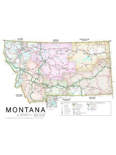
Transcription of REGION 2 - Lower Mainland - British Columbia
1 5-35-45-55-61-41-31-51-71-61-101-151-21- 18-58-43-313-173-163-333-323-133-143-15 VICTORIAS idneyDuncanPort RenfrewJordanRiverBamfieldLadysmithNANAI MOPORT ALBERNICOURTENAYCAMPBELL RIVERC omoxParksvilleSquamishPembertonWhistlerL angleySurreyAbbotsfordMissionHopePrincet onBoston BarSpuzzumLyttonMerrittLillooetGoldBridg e100 Mile HouseCache CreekKAMLOOPSC hilliwackHarrisonHotSpringsGibsonsSechel tQualicumBeachPowellRiverVANCOUVERNORTHV ANCOUVERNewWestminsterSookeSTRAITJUANDEF UCABARKLEY SOUNDG reat Central L PhillipsArm PowellLakeMahood LCanimLCarpenter LakeLillooet LakeHarrison LakeStave LakeAlouette LPittLakeRoss LakeBonaparteLKamloops LakeAnderson LSeton L AlberniInletGabriola IslandDenman IslandQuadraIslandSonoraIslandHornbyIsla ndTexada IslandGaliano IslandSaltspring Island NitinatL Taseko Lakes Tatlayoko LakeCowichan L HOWESOUND JERVISINLETSALMONINLET TOBAINLET BUTEINLET CHILKO LAKESan Juan R Gordon R Nanaimo R Nitina t R Leech R Jordan R Muir Cr R Chemainus R Oyster R Klinaklini R Homathko R Mosley Cr Chilko R Taseko R Bishop R Toba R Southgate R Big Cr Squamish R Elaho R Ashlu Cr LILLOOET river Cowichan R Chilcotin river Churn Cr Dog Cr FRASER river Bridge river Yalakom R Cayoosh Cr Stein R Nicola R Guichon Cr Bonaparte R Deadman R
2 Nahatlatch R Coldwater R Stave R Pitt R Anderson R Coquihalla R Skagit R Big Silver Cr Mamquam R Cheakamus R Green R THOMPSON R Tulameen R U S AChilliwack RLord R2-12-22-3 2-4 2-82-52-72-92-62-19 2-16 2-102-122-112-132-142-152-18 2-174 REGION 2 - Lower MainlandThe Management Unit boundaries indicated on the map above are shown only as a reference to help anglers locate waters in the REGION . For more precise Management Unit boundaries, please consult one of the commercial Recreational Atlases available for and Wildlife Regional Office(604) 586-4400 200-10428 153 StSurrey BC V3R 1E1 Conservation Officer Service Please call 1-877-952-7277 for recorded information or to make an appointment at any of the following Field Offices:Mission, North Vancouver, Powell river , Sechelt, and SquamishRAPP Report All Poachers and Polluters Conservation Officer 24 Hour Hotline 1-877-952-RAPP (7277)Please refer to page 78 for more Information: Fisheries and Oceans Canada District Offices (DFO)Chilliwack: (604) 824-3300 Delta: (604) 666-8266 Langley: (604) 607-4150 Mission: (604) 814-1055 Squamish.
3 (604) 892-3230 Steveston: (604) 664-9250 Vancouver: (604) 666-0384 Shellfish Information line: (604) 666-2828 STAY UP TO DATE: Check website for in-season changes or closure dates for the 2021-2023 season at: INFORMATION202021-2023 BC Freshwater Fishing Regulations SynopsisRegional RegulationsREGION 2 - Lower Mainland21 Atlantic SalmonPlease refer to the salmon section, p. 78 INVASIVE SPECIES ALERTG eneral RegulationsNo Fishing: in any lake in the UBC Malcolm Knapp Research Forest near Maple barbless hook: must be used in all streams of REGION 2, all year. See definition of angle and streams on page fin fish as bait: only permitted in REGION 2 when sport fishing for sturgeon in the Fraser river , Lower Pitt river (CPR Bridge upstream to Pitt Lake), Lower Harrison river (Fraser river upstream to Harrison Lake).
4 See page 8 for fishing in the Lower Mainland REGION : Your basic licence must be validated with a Conservation Surcharge Stamp if you fish for steelhead anywhere in See page 6 for details. When you have caught and retained your daily quota of hatchery steelhead from any water, you must stop fishing that water for the remainder of that Species: it is illegal to fish for or catch and then keep protected species. In REGION 2, these include: Nooksack dace Salish sucker Green sturgeon Cultus Lake sculpinSee page 9 for details. NOTICE TO ANGLERS The area known as the Rubble Creek Landslide Hazard Area is a high risk slide area. People who fish in this area do so at THEIR OWN 2 Daily Quotas(See tables for exceptions) Trout/char: 4, but not more than 1 over 50 cm (2 hatchery steelhead over 50 cm allowed) 2 from streams (must be hatchery) 1 char (bull trout, Dolly Varden, or lake trout)And you must release: Wild trout/char from streams All wild steelhead Hatchery trout/char under 30 cm from streamsNOTE: There is no general minimum size limit for trout in lakesBass: 20 (excluding Mill Lake - see page 24 for quota)Crappie: 20 Crayfish: 25 Kokanee: 5 (none from streams)Whitefish: 15 (all species combined)White Sturgeon: CATCH AND RELEASE ONLY Fraser river .
5 CLOSED TO ALL FISHING in the Fraser areas of Jesperson s Side Channel, Herrling Island Side Channel and Seabird Island north Side Channel, May 15-July 31 (to view a map of this area see page 26).Possession QuotasPossession quotas = 2 daily quotasAnnual QuotasAnnual catch quota for all : 10 steelhead per licence year (only hatchery steelhead may be retained in )Daily & Annual Quotas for SalmonPlease refer to the NOTICE on page 77 for salmon Trout Reward Tagging ProgramChilliwack Lake and Upper Pitt river : $100 reward tags are being used to assess the bull trout fishery. Refer to page 76 for instructions on what to do if you catch a fish with a reward river Steelhead MarkingMaxillary ( jaw) clipping is being used to assess hatchery release strategies.
6 Refer to page 76 for instructions on what to do if you catch a maxillary clipped Boundaries on Rivers in REGION 2 NOTE: Provincial freshwater regulations apply upstream of these boundaries and Federal tidal regulations apply downstream of these boundaries:Brunette R.: Burlington Northern Railway BridgeCampbell R.: Burlington Northern Railway BridgeCapilano R.: CN Railway BridgeCoquitlam R.: Mary Hill Bypass BridgeFraser R.: CPR Bridge at MissionKanaka Cr.: CPR BridgeNathan Cr.: CN Railway BridgeNicomekl R.: Burlington Northern Railway BridgePitt R.: CPR BridgeSerpentine R.: Burlington Northern Railway BridgeSeymour R.: CN Railway BridgeSquamish R.: a line running true west from the tip of the Squamish Dyke ( Windsurfer Spit )Stave R.
7 : CPR BridgeWest Cr.: CN Railway BridgeWhonnock Cr.: CP rail lineYork Cr.: CP rail line NOTE From one hour after sunset to one hour before sunrise fishing is prohibited on portions of the Fraser, Harrison, and Pitt Rivers (see Water-specific Tables for details) To find out the time of sunrise and sunset consult a local newspaper or the National Research Council of Canada website at for a sunrise-sunset Creek Landslide Hazard AreaBrandywine FallsProvincial ParkGaribaldiProvincial ParkL4100 GaribaldiRoe CrChance CrTaylor CrDaisy LakeRubble 2 2 799 Cheakamus R2021-2023 BC Freshwater Fishing Regulations SynopsisREGION 2 - Lower Mainland222021-2023 BC Freshwater Fishing Regulations SynopsisWATER BODY | MGMT UNITEXCEPTIONS TO THE REGIONAL REGULATIONSALICE LAKE 2-7No powered boatsALOUETTE LAKE 2-8 Bull trout (char) release No vessels in swimming areas, as buoyed and signed.
8 Speed restriction (8 km/h) at south end of lake, south of a line drawn from the BC Parks boat ramp to signs on the east side of the lakeALOUETTE river 2-8No Fishing upstream of the fishing boundary signs near the Alouette river Unit of the Corrections BranchNo Fishing upstream of 216th Street (including North Alouette river ), May 1-June 30; no powered boats on mainstemALPHA LAKE 2-9 Electric motors onlyALTA LAKE 2-9No Fishing Dec 1-Mar 31 Release all kokanee, trout and charBait ban, single barbless hoookSpeed restriction (12 km/h)ANDERSON CREEK 2-4No FishingANGUS CREEK2-5No FishingASHLU CREEK2-6 Bait banBEAR (Mahood) CREEK 2-4No Fishing upstream of 152nd Street (Johnson Road)BEAR LAKE2-18No powered boatsBIG SILVER CREEK2-18No Fishing May 1-June 30 BIRKENHEAD LAKE2-11 Bull trout (char) releaseBIRKENHEAD river 2-11 Bait banBREM river 2-13No Fishing from the upstream edge of falls (situated approximately km from the river s mouth)
9 To a point 100 m downstreamBait ban May 1-Oct 31 BROTHERS CREEK 2-8No FishingBROWNING LAKE 2-8No powered boatsBRUNETTE RIVER2-8No Fishing from Cariboo Dam to Salamander Creek; release all steelheadBRUNETTE river S TRIBUTARIES2-8No FishingBURNABY LAKE2-8No powered boatsBURNABY LAKE S TRIBUTARIES2-8No FishingCAMPBELL river 2-4No Fishing upstream of 12th AvenueNo Fishing downstream of 12th Avenue Apr 1-June 30No Fishing between two white triangular fishing boundary signs downstream to pedestrian bridge at the foot of Stayte Road, Aug 15-Sept 30No Fishing from 21:00 hours to 05:00 hours each day, Aug 1-Dec 31 CAPILANO river 2-8No Fishing upstream of fishing boundary signs at footbridge situated approximately 100 m downstream of the fish fenceBait ban, Aug 1-Oct 31.
10 Release all steelheadCEDAR LAKE2-2 See Sumallo RiverCHAPMAN CREEK2-5No Fishing May 1-June 30No Fishing from the falls to 100 m downstream (falls are located approximately 550 m upstream of the power line crossing) CHEAKAMUS RIVER2-7 Bait banCHEAM LAKE2-3No FishingCHEEKYE river 2-7No Fishing (including Brohm Creek)CHEHALIS LAKE2-19No wild trout/char over 50 cmCHEHALIS LAKE S TRIBUTARIES2-19No FishingCHEHALIS river 2-19No Fishing from fishing boundary signs at the outlet of Chehalis Lake to the main logging road bridge situated approximately km down-stream of Chehalis LakeNo Fishing downstream of the main logging road bridge situated approximately km downstream of Chehalis Lake, May 1-31 CHILLIWACK LAKE2-4No wild trout/char over 50 cmCHILLIWACK / VEDDER RIVERS (does not include Sumas river )(see map on page 24)