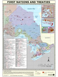
Transcription of Regulation Plan Map of Fisheries Management Zone 18 ...
1 Statutory Order and Regulation / Decrets, Ministry of LEGEND. ordonnances et reglements statutaires No. _ _ 2007-237. _____ Natural Wetland Area, Permanent NOTES: SCHEDULE No. _ _ _ _ _ _ _ _ _ _ _ _ _ _ _ _ _ _ _ _ _ _ _ _ _ _ _ _ _ _ _ _ Ontario Resources Digital Mapping Transportation FMZ Boundary 1. Map projection, grid, and coordinates are in UTM NAD 83 Zone 18. CERTIFICATE OF SURVEYOR GENERAL Provincial Parks & Crown 2. Survey instructions from the Surveyor General must be obtained prior to SHEET 1 0F 7. Regulation Plan of Fisheries Waterways Geographic Townships establishing any of the boundaries on the ground. DATE COMPLETED _ _MAY. _ _ _2006. _____ Game Preserve 3. "C/L OF ROAD" means the centreline of the pavement/gravel or the I HEREBY CERTIFY THAT THIS PLAN HAS BEEN FILED Lakes centreline of the median where the highway is divided.
2 WITH THE OFFICE OF THE SURVEYOR GENERAL OF. Railway 4. "C/L OF RAILWAY" denotes the centreline of all tracks where tracks exist or the centreline of bed where no tracks exist. 0 10 20 30 40 50. ONTARIO IN THE MINISTRY OF NATURAL RESOURCES This plan was compiled from data sets supplied by the Land km Management Zone 18. ON THE 30TH DAY OF MAY 2006. Information Ontario (LIO) Warehouse, Ontario Roads Network and FMZ Fisheries Management Zone WE denotes Water's Edge 5. Where necessary all limits are extended unless otherwise noted. other information of record in the Ministry of Natural Resources. 6. Where a Fisheries Management Zone limit crosses a body of water along a road C/L denotes Centreline or railway bridge, the downstream edge of the bridge shall be deemed to be the ORIGINAL SIGNED BY _____. MACINTOSH. FOR B. MALONEY.
3 Limit of the said Fisheries Management Zone. 1:275,000.. PRODUCED BY: The Office of the Surveyor General CAUTION: THIS IS NOT A PLAN OF SURVEY. SURVEYOR GENERAL. 270000. 300000. 330000. 360000. 390000. 420000. 450000. 480000. 510000. 540000. GUTHRIE. 5070000 ALICE 5070000. WESTMEATH. #. Algonquin Provincial Park FRASER. CLANCY STAFFORD. RICHARDS. BURNS. Round Lake DICKENS. NORTH ALGONA. WILBERFORCE. ROSS. FMZ 12 Ottaw a Riv er WE. MURCHISON. Golden Pembroke BROMLEY. HAGARTY. Lake O. tta wa DETAIL 12 Hawkesbury #. Ri r Y6. 0 ve ve WE. HW 0 r Ri Y6 wa HW ALGONA. SHERWOOD. DETAIL 11 O tta DETAIL 13 Carillon Provincial Park Y. ALFRED WEST HAWKESBURY. 5040000 HORTON 5040000. DAAR. JONES EAST HAWKESBURY. Renfrew FMZ 15. Bark Fitzroy Provincial Lake Park WE. OUN. GRATTAN. LYELL CLARENCE. PLANTAGENET CALEDONIA. Lake Clear LB.
4 HW. ADMASTON WE TORBOLTON. Y4. 7. INCIA. BRUDENELL 41. 1. Kamaniskeg SEBASTOPOL CUMBERLAND Y. Lake Ottawa HW. RADCLIFFE 32 McNAB. DETAIL 10. W. Y1 O. PROV. HW tta E. FITZROY wa (White Lake) Ri LOCHIEL. ve BANGOR MARCH. r ARIO. #. BEC. GLOUCESTER. WE. WICKLOW HW. ONT. Y 41. QUE. 7. BAGOT. RE. RAGLAN GRIFFITH. BROUGHAM. DETAIL 9 PAKENHAM. HW. Y. 41. 7. NEPEAN. CAMBRIDGE. LYNDOCH ke KENYON. La HUNTLEY. PR. e hit DETAIL 6 DETAIL 8 Calabogie Lake W. O. VI. Lower Madawaska River RUSSELL. NC. (Crankshaw Lake) (Norcan Lake). Provincial Park IA. CARLOW. L. #. BO. BET. 5010000 5010000. Black Donald Lake WE. HW. #. LANCASTER. U. PS BLITHFIELD 7. SHI. #. ND. Y6. Y. DETAIL 5. WE. ROXBOROUGH. N HW. BOU TOW. TOW. AR. 2. MONTEAGLE. E DARLING. EEN W. EN. OSGOODE. DETAIL 14. Y. (Lily Lake) W. HW. RAMSAY. NDA NSH. BET MATAWACHAN GOULBOURN.
5 Y. ARY (Lake St. Francis). 41. D Norcan N DENBIGH. 6. RY. Centennial BOU. HERSCHEL Lake FINCH. #. Lake NORTH CANONTO. PS. cis HWY 41. NORTH GOWER. an IPS. E. Carleton Place CHARLOTTENBURGH r SHI. t. F. W. k eS. La N. LAVANT. ASHBY. T OW. #. WINCHESTER. MAYO. EB O. 1. 40. QU TARI. LANARK. EC. Y. Bancroft HW. DETAIL 15. EEN. SOUTH CANONTO BECKWITH. DETAIL 4. ON. DUNGANNON. DETAIL 7 Mississippi CORNWALL. W. Lake (Weslemkoom Lake) Cornwall HW. T. (Montserrant Lake). BE. Y1. Weslemkoon MARLBOROUGH MOUNTAIN. OSNABRUCK. 5. r Lake ve Ri WE. MILLER. au iver ce R. #. FARADAY ABINGER. ide en R SOUTH GOWER A r Kemptville aw DALHOUSIE. NAD .t L. C A S. ARY. A. EFFINGHAM. DRUMMOND. US. WILLIAMSBURGH. ND. 4980000 CASHEL 4980000. PALMERSTON. BOU. MONTAGUE. OXFORD (ON RIDEAU). 01. NORTH SHERBROOKE Y4. LIMERICK Bon Echo Smith Falls HW.
6 Crotch DETAIL 2 Limerick PS. Provincial Park CLARENDON. Lake er I. NSH. Lake MATILDA. Riv 7. (Steenburg Lake) TO W HW. Y. E. eau BATHURST. W. FMZ 18. WOLLASTON. Rid HW. BARRIE. Y. CHANDOS Wollaston 41. #. #. Lake 6. Chandos Lake ET WEEN DETAIL 3 ANGLESEA Big Gull Lake ELMSLEY. WOLFORD. EDWARDSBURGH. R YB (Wadsworth Lake). OUNDA SOUTH SHERBROOKE. B GRIMSTHORPE. HWY 41. OSO BURGESS. TUDOR. DETAIL 1 Lingham Lake OLDEN. Sharbot Lake Murphys Point Otter Lake Provincial Park KITLEY E. KENNEBEC. W. 15. AUGUSTA. LAKE. DETAIL 16. Y. HW. C/ 7 Big Rideau Y. L HW Lake O. F r NORTH CROSBY ve Crow Ri Co 4950000 4950000. RO. METHUEN e un KALADAR Lake nc AD. C/L OF re ty w R. BASTARD. La d. ROAD . St 46. Kasshabog Lake ELIZABETHTOWN. ELZEVIR.. C/L. Oak # Rd e BEDFORD. Lake l Mi Newboro OF. MADOC. Devils 4. WY. HINCHINBROOKE Lake Brockville Van HW.
7 Cordova 6. ROA. Lake Y 62. sic MARMORA. Devil SOUTH CROSBY. kle R. D. Lake Sand d. YONGE. Lake SHEFFIELD Frontenac C/L. Charleston Provincial Park Lake Round Belmont HWY 7. OF. Lake Lake Charleston Crowe E. Lake Provincial W. RO Rd. Moira Co Lake Marmora Park rd o BELMONT Lake AD. Stoco va Lake 5. Y1 LANSDOWNE. HW. r HUNGERFORD ESCOTT. ve PORTLAND. Ri LOUGHBOROUGH. nce re HUNTINGDON Dog Cou 4920000 Lake LEEDS aw 4920000. ke .L. nty La St h R. CAMDEN EAST. ug PITTSBURGH. d. 1. C/L. ro 1. RAWDON. bo 40. 4/S. Y. n gh HW. OF. Lo tirlin DEL. g-M. ROA. o SEYMOUR. rma D. DETAIL 17. ra R. WE. d. Colonel By (Cataraqui River). CY. # Stirling RICHMOND Lake Key Plan Fisheries Management Zones DETAIL 18 KINGSTON. #. River AD. C/L OF ROAD HWY 401. Trent TYENDINAGA. 1. 33. RO. West Front St. (Millhaven Creek).. THURLOW. Napanee Rd PERCY Howe Island Kingston F.
8 ERNESTOWN. nty O. L. DETAIL 19. ou C/. C. HW. Y6. FMZ 17. SIDNEY. (Bay of Quinte) 2. 2. Pwy. #. Belleville FREDERICKSBURGH 3. C/L OF ROAD. WE. Riv er side n el 4. h an WE hC. WE ort . MURRAY N Wolfe Island Bay of Quinte 5. 4890000 Trenton Amherst Island 6 8 4890000. 7. WE 9. 01 SOPHIASBURGH Superior CRAMAHE Y4 Bay of HW E. Quinte W 10. 11 12. 14 15. AMELIASBURGH Prince Edward 10 18. Huron 13. igan 17. 20. Mich 16 Ontario US DA. FMZ 20. NA. 19. A. CA. 0 100 200 400 Er ie 19. km Lake Ontario HALLOWELL MARYSBURGH. 270000. 300000. 330000. 360000. 390000. 420000. 450000. 480000. 510000. 540000. FMZ18-04 APR2006_Sheet1.