Transcription of Rio Grande an International Boundary River Is Drying up ...
1 Open Journal of Soil Science, 2021, 11, 587-610. ISSN Online: 2162-5379. ISSN Print: 2162-5360. Rio Grande an International Boundary River Is Drying up and in Need of Restoration Kenneth R. Olson1 , James M. Lang2. 1. Soil Science in Department of Natural Resources, University of Illinois, Urbana, Illinois, USA. 2. Department of Crop Sciences, College of Agricultural, Consumer, and Environmental Sciences, University of Illinois, Urbana, Illinois, USA. How to cite this paper: Olson, and Abstract Lang, (2021) Rio Grande an Interna- tional Boundary River Is Drying up and in The headwater source of the Rio Grande is in the Colorado San Juan Moun- Need of Restoration. Open Journal of Soil tains as it flows southeast and south. The River crosses deserts and steppes, Science, 11, 587-610.
2 Watering rich irrigated agricultural regions as it drains into the Gulf of Mex- ico near Brownsville, Texas. The River flow pattern is disrupted by hundreds Received: November 20, 2021 of dams and irrigation diversions, which has left sections of the Rio Grande Accepted: December 11, 2021 River dry. The lower Rio Grande Valley including the Rio Grande Delta is Published: December 14, 2021. heavily irrigated and has become an important agricultural region. Since the Copyright 2021 by author(s) and mid-1990s, the flow has been reduced to 20% because of many large diver- Scientific Research Publishing Inc. sions, dams and consumption of water by cities and irrigated farmland. Even This work is licensed under the Creative with a series of 2001 and 2002, Mexico-United States agreements adminis- Commons Attribution International License (CC BY ).
3 Tered by the International Boundary and Water Commission (IBWC) the Rio Grande River had continued to failed to reach the Gulf of Mexico. Mexico Open Access and United States share the River . Historically, the Rio Grande has provided limited navigation and border security. There is a need to restore navigation and shipping by creating a lock and dam system from El Paso, Texas and Matamoros, Mexico to the Gulf of Mexico, In addition there is also a need to restore border security for the lower Rio Grande , an International border River . If the Rio Grande is ever going to recover, it will require a lock and dam system and an increased River flow. The increased flow needs to be achieved by adding additional water from feeder lakes, a water pipeline, and a balanced approach to water management must include efficiency measures and aggres- sive conservation in urban areas and on irrigated agricultural lands.
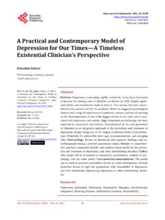
4 Keywords Big Bend National Park, Mexico Border, Brownsville and Matamoros International Bridge, Port Brownsville, Rift Cross Section, Thornforest, Restoration DOI: Dec. 14, 2021 587 Open Journal of Soil Science K. R. Olson, J. M. Lang 1. Introduction The Rio Grande is Drying up and in need of mitigation. The 1600 m long, lower Rio Grande River was a natural barrier to illegal immigration between Mexico and United States. Historically the River provided navigation, limited shipping and border security. There is a need to restore Rio Grande water levels to permit navigation shipping and restore border security. The Rio Grande River headwa- ters are in Colorado (Figure 1) and the River flows along the Mexico-United States border and into the Gulf of Mexico.
5 The watershed area is 472,000 km2 [1]. without including the many endorheic basins near the Rio Grande basin. When added, the watershed size is increased to 870,000 km2 [2] and covers 11% of the continental United States. The River is the natural border between Texas and Coahuila, Chihuahua, Tamaulipas and Nuevo Leon, Mexico [2]. Figure 1. Rio Grande watershed in Mexico and the United States. Map by Mic Greenberg. DOI: 588 Open Journal of Soil Science K. R. Olson, J. M. Lang The first good cartography and survey of the Rio Grande River started in 1853. when the International Boundary commissioners conducted fieldwork directed by Mexican commissioners and surveyors plus United States equivalents [3]. Between 1850s and 1874, small steamboats navigated the lower Rio Grande River [2].
6 A hurricane removed all manmade structures, silting and sandbar formation because of accelerated soil erosion prevented navigation and forced Mexico and United States to spend time and money to adjust the International Boundary as a result of changes in the location of the River channel. During the 1830s and 1840s, there was a border dispute between Mexico and the Republic of Texas. Mexico claimed the border to be Nueces River rather than the Rio Grande River . After Texas had become a state in 1846, this disagreement provided part of rational for the United States invasion of Mexico [4]. Naviga- tion on the Rio Grande was active during much of the 1900s. Over 200 steam- boats operated on the Rio Grande River near Brownsville [3]. To restore naviga- tion the engineering challenge would be to create a lock and dam system with feeder lakes and a pipeline to maintain a year-around shipping canal [5] capable of operating in dry periods.
7 The biggest natural obstacles are water supply and elevation change between El Paso and Ciudad Juarez and the Gulf of Mexico. El Paso and Ciudad Juarez are 1100 m above sea level and the distance from the Gulf of Mexico is approximately 1600 km, with an actual gradient is about m per km [3]. The primary objectives are: (1) to create a 1600 km lock and dam system on the lower Rio Grande , an International border River , between Brownsville, Texas and Matamoros, Mexico and El Paso, Texas and Ciudad Juarez, Mexico to per- mit year around shipping, navigation and trade and (2) to create a series of feeder lakes, a water pipeline and locks and dams in both the United States and Mexico to enhance the border security by restoring the historically high water levels of the Rio Grande River .
8 This could result in the reduction of the number of illegal immigrants who can walk (rather than swim, boat or float) across the Rio Grande River east of El Paso and Matamoros and reduce the use of soil tun- nels under the 1600 km long lower Rio Grande River . 2. Site Location The Rio Grande is the 20th longest River in the world and the fifth longest in North America. The total length is 3051 km with a 3700 m elevation change as it drops from the Rocky Mountains to sea level at the Gulf of Mexico (Figure 1). Before entering the Gulf Coastal Plain, the Rio Grande cut three canyons (Figures 2-4) to a depth of between 460 to 520 m across a faulted upland area. The Rio Grande River tributary water drains through a canyon and forest of spruce (Picea), fir (Abies) and aspen (Populus tremuloides) and into the San Luis Valley.
9 Then it drains into Rio Grande Gorge and White Rock Canyon. It flows into the open terrain of the basin and then through the Mexican Plateau. As the latitude and elevation of the Rio Grande declines, the increasing aridity and temperature of the water produces vegetation including pinion pine (Pinyon DOI: 589 Open Journal of Soil Science K. R. Olson, J. M. Lang Pinus, subset Cembroides), juniper (Juniperus) and sagebrush (Artemisia pyg- maea) to a hot desert and steppe climate with mesquite (Prosopis), cactus (Ler- rea tridentata) (Figure 5), creosote brush and yucca (Yucca). The Texas side of the River is occupied by the Big Bend National Park (Figure 6). The Rio Grande River wanders across the Gulf Coastal Plain and empties into the delta near Brownsville where it joins the Gulf of Mexico (Figure 7).
10 Figure 2. The Rio Grande River flowing through an arid desert. Figure 3. The Rio Grande River north of Albuquerque, New Mexico. Figure 4. Rio Grande Horseshoe Bend on the Rio Grande Riv- er. DOI: 590 Open Journal of Soil Science K. R. Olson, J. M. Lang Figure 5. Cactus growing at a park adjacent to the Rio Grande in Albuquerque. Figure 6. The Rio Grande River watershed in the Big Bend area. Figure 7. The Mexico-United States border showing the border wall locations and Big Bend State Park. Map by Mic Greenberg. Reprinted with the approval of the OJSS editor. DOI: 591 Open Journal of Soil Science K. R. Olson, J. M. Lang Geology During the past 35 million years the Rio Grande rift (Figure 8), caused by tec- tonic plates in Earth's lithosphere, moved apart and represents the eastern most example of widespread stretching in western United States.