Transcription of Risk Assessment Process Handbook - Disaster Management
1 QUEENSLAND EMERGENCY. RISK Management FRAMEWORK (QERMF). RISK Assessment . Process Handbook . Prepared by Community Resilience and Risk Mitigation Unit, Emergency Management and Community Capability, Queensland Fire and Emergency Services Queensland Emergency Risk Management Framework (QERMF) Risk Assessment Process Handbook Contents Overview 4. Aim of the Handbook 4. Benefits of this risk Assessment Process 4. The Queensland Emergency Risk Management Framework's approach to managing risk 5. Step one: Establishing the context 6. Step two: Analysing hazards 6. Step three: Assessing risk 6. Step four: Risk based planning 7. Hazards 8. Risk Assessment Process : snapshot 10. Why assess hazards using this methodology? 11. 2. Risk Assessment Process : in detail 12. Process 1: Identifying risk 12. Step 1 HAZARD: assessing the hazard against the probability of occurrence 13. Step 2 EXPOSED ELEMENTS: identifying the elements at risk 15.
2 Step 3 VULNERABILITY: assessing the vulnerability of exposed elements 18. Process 2: Determining level of risk 20. Step 1 LIKELIHOOD: assessing the likelihood of occurrence 21. Step 2 VULNERABILITY: finalisation of vulnerability Assessment 23. Step 3 CONSEQUENCE: Assessment of the likely impact 25. Risk Statement development 27. Assigning the level of risk 28. Risk treatment 29. Risk documentation 31. Risk Assessment Table 31. Risk Register 32. Decision Log 32. Action plan: risk Assessment Process 34. Appendices 35. Appendix 1 Calculating Annual Exceedance Probabilities (AEP) 35. Appendix 2 Vulnerability Table 37. Appendix 3 Consequence Table 38. Appendix 4 Risk matrix 40. Appendix 5 Sample Risk Assessment Table 41. Appendix 6 Sample Risk Register (Infrastructure) 43. Appendix 7 Decision Log 46. Appendix 8 Risk Assessment Process on a page 47. Glossary 48. Bibliography 52. List of Figures Figure 1 - Queensland Emergency Management Risk Framework 5.
3 Figure 2 - QERMF Hazards Table 9. Figure 3 - Methodology for identifying risk 12. Figure 4 - Geospatial overlay of Gold Coast Disaster District 17. Figure 5 - Methodology for assigning Level of Risk 20. Figure 6 - Consequence Wheel 26. Figure 7 - Risk Based Planning Equation 30. Figure 8 - Tropical cyclone data overlayed onto Mackay Disaster District (ArcGIS) 35. List of Tables Table 1 - Probability Table 13. 3. Table 2 - Likelihood Table 21. Table 3 - Risk Matrix 28. Table 4 - Action plan 34. Queensland Emergency Risk Management Queensland Emergency Risk Management Framework (QERMF) Risk Assessment Process Handbook Overview Aim of the Handbook This Handbook provides a valuable risk Assessment methodology that can be used within Disaster Management planning at all levels of Queensland's Disaster Management Arrangements (QDMA) Local, District and State. The Process applies a proven, standardised and internationally recognised approach to the prioritisation, mitigation and Management of risk.
4 This includes identification of capacity gaps and residual risk between stakeholders and the QDMA. This assists to directly inform planning and resource allocation, and to promote active communication, cooperation and coordination. This Handbook outlines both the framework and approach for this risk Assessment Process in a step-by- step manner and provides examples, resources and templates to assist in its implementation. Benefits of this risk Assessment Process In short, this Process ensures four key outcomes: 4. shifts risk Assessment and Management from a one size fits all' approach to a tailored methodology that accounts for the prioritisation of local characteristics embeds risk identification, Assessment and Management in proven, consistent, science-based methodologies that can be applied consistently across all levels of QDMA (Local, District and State). allows clarity and transparency in communication and decision-making at all levels of QDMA.
5 Improves the identification of an area's capability and capacity to manage the risks within that area, thereby informing resource planning for QDMA. This in turn will create multiple benefits, including: risk governance will be improved through the strengthening of transparency and accountability in the acceptance, mitigation and/or transfer of residual risk between and across the three levels of QDMA. specific areas can prioritise their resources, based on localised assessed risks robust, scientifically-based risk assessments can be used for applications for resources and funding towards mitigation strategies and betterment projects all levels of government and community will have greater assurance through and confidence in scientifically underpinned risk based planning stakeholders will have improved confidence in State level coordination and support across all levels of QDMA, supported by State Government guidance and prioritisation of hazard risk Disaster Management networks will be strengthened and better aligned.
6 The QERMF is underpinned by a multidisciplinary approach, uniting international and Australian best practice, the strategic direction of world risk Management leaders and using operational geospatial intelligence to undertake exposure and vulnerability analysis which can directly inform the State's multitiered Disaster Management arrangements and planning. The QERMF derives risk methodology from: ISO 31000:2009 Risk Management Principles and guidelines SA/SNZ HB 436: 2013 Risk Management guidelines companion to AS/NZS ISO 31000:2009. SA/SNZ HB 89:2013 Risk Management Guidelines on risk Assessment techniques AS/NZS 5050: 2010 Business continuity Managing disruption related risk National Emergency Risk Assessment Guidelines (NERAG) (Australian Emergency Management Institute, 2015). In addition to the above international and national standards, the QERMF also upholds international best practice as championed by the United Nations Office for Disaster Risk Reduction (UNISDR) and the Global Facility for Disaster Reduction and Recovery (GFDRR) and seeks to literally enact the Sendai Framework for Disaster Risk Reduction's (Sendai Framework) Priorities for Action.
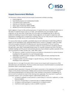
7 The Queensland Emergency Risk Management Framework's approach to managing risk The concept of risk combines an understanding of the probability of a hazardous event occurring with an Assessment of its impact represented by interactions between hazards, elements at risk and vulnerability. (Geoscience Australia). 5. Figure 1 - Queensland Emergency Risk Management Framework The successful foundation for Disaster risk Management lies in clearly identifying and understanding the level of exposure and vulnerability to a community and its assets against particular hazards. Effective risk assessments produce information that is targeted, authoritative, understandable and usable. The model above depicts the overarching risk based planning methodology within the QERMF. This model shows the four clear steps to ensuring the identification, analysis and Management of risk, summarised overleaf. 1.
8 Global Facility for Disaster Reduction and Recovery (2014) Emerging Best Practices in Natural Disaster Risk Assessment . World Bank Queensland Emergency Risk Management Queensland Emergency Risk Management Framework (QERMF) Risk Assessment Process Handbook Step one: Establishing the context The processes shown within the first step of the QERMF establish the context of the area under Assessment . This includes understanding the natural landscape through the study of the environment and/or by accessing basic geomorphology information. Much of this information is available through local governments as well as the Queensland Government. Typically, this Assessment begins with an appreciation of the lay of the land' via geospatial data/layers, which highlight the specific characteristics of the natural environment. Next, this information is integrated with the specific characteristics of the area's community (its demography) and built environment (its infrastructure, road networks, buildings), as well as any socially or culturally valued areas or sites (such as sacred sites, environmentally sensitive areas, tourist spots, churches and community centres or key landmarks).
9 It is particularly important to identify critical and significant infrastructure (such as power, water, communications) as well as the associated networks and dependencies/interdependencies they need 6 to effectively operate (and be accessible) as damage or disruption to these elements requires immediate response and can launch a cascade of associated vulnerabilities. The majority of this information can be displayed in geospatial layers and is a precursor to commencing the actual risk Assessment Process . Geospatial layers can create an accurate visualisation of how the hazard will manifest on the local natural and built environment, which in turn informs our Assessment of the vulnerabilities we have and our capability and capacity to manage those vulnerabilities. Step two: Analysing hazards The second step focuses on hazards and how they will behave when they actually occur. Identifying relevant hazards and collecting hazard-related data is essential when quantifying risk.
10 Relevant hazards are identified through probabilistic analysis of historical data for a specific area or region. Once the hazards are defined, the next step involves acquiring a variety of hazard related data. Hazard specific data, layers, mapping and modelling is available through Geoscience Australia, the Bureau of Meteorology and the Department of Science, Information Technology and Innovation, as well as other agencies and local governments. The most fundamental data define historical events including their date, geographical location and extent, and maximum intensity. However, this information is only the beginning, as we will discuss further in this Handbook . Step three: Assessing risk The third step formalises the risk analysis Process and leads directly to the clear identification of risk that may arise when a potential hazard becomes reality. This Process also includes reviewing existing controls to manage or mitigate risks and identifying any capability or capacity gaps in meeting the required response.