Transcription of SIGMET QUICK REFERENCE GUIDE WS SIGMET - ICAO
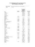
1 SIGMET QUICK REFERENCE GUIDEWS SIGMETWS SIGMETA SIGMET provides concise information issued by a Meteorological Watch Office (MWO) concerning the occurrence or expected occurrence of specific en-route weather and other phenomena in the atmosphere that may affect the safety of aircraft operations. The WS SIGMET provides information on phenomena other than tropical cyclones and volcanic ash. SIGMET Structure WMO Header Bulletin identificationTTData type designatorWS for SIGMET for phenomena other than volcanic ash cloud and tropical cycloneAACountry or territory designatorsAssigned according to Table C1, Part II of Manual on the Global Telecommunication System, Volume I Global Aspects (WMO Publication No.)
2 386)iiBulletin numberAssigned on national level according to Part II of Manual on the Global Telecommunication System, Volume I Global Aspects (WMO Publication No. 386)Disseminating centreCCCC is the ICAO location indicator of the communication centre disseminating the message (this may be the same as the MWO location indicator).Transmission timeYYGGgg is the date/time group; where YY is the day of the month and GGgg is the time of transmission of the SIGMET in hours and minutes UTC (normally this time is assigned by the disseminating (AFTN) centre).ABVA boveCNLC ancel or cancelledCTAC ontrol areaFCSTF orecast FIRF light Information Region FLFlight level FTFeetINTSFI ntensify or intensifying KTKnots KMHK ilometres per hourMMetresMOVM oving NCNo Change (in intensity) NMNautical Miles OBSO bserved SFCS urfaceSTNRS tationary TOPTop (of CB cloud)WIWithin (area) WKNW eakening (intensity) ZCoordinated Universal Time SIGMET AbbreviationsCorrection indicatorBBB should only be included when issuing a correction to a SIGMET which had already been transmitted.
3 The BBB indicator shall take the form CCx for corrections to previously relayed bulletins, where x takes the value A for the first correction, B for the second correction, etc., for a specific line of SIGMETL ocation indicatorCCCC is the ICAO location indicator of the ATS unit serving the FIR or CTA to which the SIGMET identifierThe message identifier is numberThe daily sequence number in the form [n][n]n, 1, 2, 01, 02, A01, A02, restarts every day for SIGMETs issued from 0001 period The validity period is given in the format VALID YYGGgg/YYGGgg where YY is the day of the month and GGgg is the time in hours and minutes UTC. The period of validity for a WS SIGMET shall be no more than 4 OfficeCCCC- is the ICAO location indicator of the MWO originating the message followed by a hyphen.
4 SIGMET Main BodyFIR/CTA NameThe ICAO location indicator and full name of the FIR/CTA for which the SIGMET is issued in the form cccc <name> FIR[/UIR] or cccc <name> CodeDescriptionOBSC TSObscured thunderstorms EMBD TS Embedded thunderstorms FRQ TSFrequent thunderstorms SQL TSSquall line thunderstormsOBSC TSGRO bscured thunderstorms with hail EMBD TSGRE mbedded thunderstorms with hail FRQ TSGRF requent thunderstorms with hailSQL TSGRS quall line thunderstorms with hail SEV TURBS evere turbulence SEV ICES evere icing SEV ICE (FZRA)Severe icing due to freezing rain SEV MTWS evere mountain wave HVY DSHeavy duststorm HVY SSHeavy sandstorm RDOACT CLDR adioactive cloud Observed or forecast phenomenonWhether the phenomenon is observed or forecast in the form OBS [AT GGggZ] or FCST [AT GGggZ] where GG is hours and gg minutes icing enhancement.
5 Dark areas indicate the presence of supercooled liquid water (black by night, red by day). High level cirrus (bright areas) may prevent the satellite from seeing the lower level , Sydney, 23 September 2009. Image courtesy of Elly Spark, Bureau of Convective Storm RGB, Himawari-8. This RGB composite image is used for CB detection. Red and yellow coloured clouds are possible CB clouds (deep precipitating clouds).Anvil of a cumulonimbus cloudLocationThe location of the phenomenon is provided with REFERENCE to geographical coordinates in latitude and longitude in degrees and minutes. The number of coordinates should be kept to a minimum and should not normally exceed level and vertical extent of the phenomenon:FLnnn or nnnnM or nnnnFT or SFC/FLnnn or SFC/nnnnM or SFC/nnnnFT or FLnnn/nnn or nnnn/nnnnFT or TOP FLnnn or ABV FLnnn or TOP ABV or Expected Movement (not included if forecast time and forecast position are given)Direction and rate of movement of the phenomenon where the direction is given with REFERENCE to one of the sixteen points of the compass (using the appropriate abbreviation) and the rate is given in KT (or KMH) in the form MOV <direction> <speed>KT or KMH.
6 The abbreviation STNR (Stationary) is used if no significant movement is in IntensityThe expected evolution of the phenomenon s intensity as indicated by: INTSF or WKN or NCForecast time and forecast position (not included if movement given)The forecast position of the hazardous phenomena at the end of the validity period of the SIGMET message in the form FCST AT <GGgg>Z <location>.Renewing a SIGMETA SIGMET is renewed with a new sequence number when the validity period is due to expire but the phenomenon is expected to a SIGMETIf, during the validity period of a SIGMET , the phenomenon for which the SIGMET was issued is no longer occurring or is no longer expected, the SIGMET shall be cancelled by issuing a SIGMET with the abbreviation CNL.
7 CNL SIGMET [n][n]n YYGGgg/YYGGggSource of InformationSource of InformationPhenomenaSurface and upper-air observations Special AIREPS atellite picturesNWP forecastsThunderstorms, dust/sandstorms, turbulence, mountain waves, icingRADARL ightning informationThunderstorms WMO RSMC (Atmospheric transport modelling for environmental emergency)Radioactive cloudSIGMET DisseminationSIGMET is part of operational meteorological (OPMET) information and should be exchanged via aeronautical fixed service (AFS). The SIGMET priority indicator used shall be thunderstorms affecting the Southern China and the northern part of South China Sea on 9 May or eastern longitude ENEEast-north-eastESEEast-south-eastNNor th or northern latitude NENorth-eastNNEN orth-north-eastNNWN orth-north-westNWNorth-westSSouth or southern latitude SESouth-eastSSES outh-south-eastSSWS outh-south-westSWSouth-westWWest or western longitude WNWWest-north-westWSWWest-south-westSate llite image of mountain waves over Tasmania, 3 December cccc YYGGgg [BBB] cccc SIGMET [n][n]n VALID YYGGgg/YYGGgg cccc - cccc <FIR/CTA Name> FIR <Phenomenon> OBS/FCST [AT GGggZ]
8 <Location> <Level> <Movement> <Intensity changes> <Forecast time and forecast position>=WSSS20 VHHH 090900 VHHK SIGMET 3 VALID 090900/091300 VHHH-VHHK HONG KONG FIR EMBD TS OBS AT 0900Z N OF N2000 AND E OF E11330 TOP FL400 IN TSF FCST AT 1300Z N OF N2000 AND E OF E11300=WSAU21 ADRM 240330 YMMM SIGMET D01 VALID 240330/240430 YPDM-YMMM MELBOURNE FIR HVY DS OBS WI S2300 E13415 S2240 E13800 S2520 E13800 S2525 E13520 S2300 E13415 SFC/7000FT MOV N 25KT NC=WSCI33 ZBAA 301110 ZBPE SIGMET 2 VALID 301110/301510 ZBAA-ZBPE BEIJING FIR HVY SS OBS AT 1100Z N OF N40 SFC/2000M MOV E 30 KMH NC=WSNZ21 NZKL 232134 NZZC SIGMET 18 VALID 232134/240134 NZKL-NZZC NEW ZEALAND FIR SEV TURB FCST WI S3929 E17602 S4305 E17136 S4522 E17000 S4538 E17159 S4112 E17624 S3929 E17602 FL180/260 MOV E 25KT INTSF=WSAU21 AMRF 061700 YMMM SIGMET M07 VALID 061700/062100 YMRF-YMMM MELBOURNE FIR SEV MTW OBS WI S3704 E14244 S3611 E14753 S3736 E14943 S4006 E14800 S3952 E14353 S3704 E14244 FL080/140 STNR NC=WSCI45 ZHHH 021100 ZHWH SIGMET 3 VALID 021100/021500 ZHHH-ZHWH WUHAN FIR SEV ICE FCST N OF N28 SFC/FL200 STNR NC=WSSS20 VHHH 180830 VHHK SIGMET 1
9 VALID 180830/181230 VHHH-VHHK HONG KONG FIR RDOACT CLD FCST E OF E114 SFC/FL100 MOV E 20KT WKN=WSSS20 VHHH 181100 VHHK SIGMET 2 VALID 181100/181230 VHHH-VHHK HONG KONG FIR CNL SIGMET 1 180830/181230=WS SIGMET ExamplesFormatThunderstormsDuststormsSan dstormsTurbulenceMountain wavesIcingRadioactive cloudCancellation 4 November 2016 Refer to the following for more informationICAO Annex 3 Meteorological Service for International Air Navigation (Amd 77)ICAO Regional SIGMET GuideICAO Manual of Aeronautical Meteorological PracticeWMO Technical Regulations Volume II Meteorological Service for International Air Navigation (2013 ed)WMO GUIDE to Practices for Meteorological Offices Serving AviationGraphical SIGMET display.