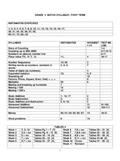
Transcription of SOCIAL SCIENCE TERMS TWO AND THREE 2010 - …
1 1 NAME: .. grade 4: .. SOCIAL SCIENCE TERMS TWO AND THREE 2010 \ 2 grade 4 SOCIAL SCIENCE SECOND and THIRD TERM SYLLABUS: DIRECTION; MAPWORK; RONDEBOSCH Page SYLLABUS 2 Investigation: The Fort (Information on grade 4 Home Page) 3 What is a map? 4 Keys and Symbols 5 Drawings from above a bird s eye view 6 Using a Map to find your Way / Grids 7 Direction the 8 points of the compass 8 Map of the World 7 continents 9 Map of Africa 10 Map of Provinces of South Africa 11 Google earth: Finding places in Rondebosch (project) 12 -13 The History of Rondebosch/ Bishops and Rondebosch (test) 14 Places of Interest in Rondebosch (PowerPoint) PRACTICAL ACTIVITIES Visit to Cape Town Castle Walk along Liesbeeck River Map Detective THE CAPE TOWN CASTLE Marks for 2nd Term Investigation: The Fort (20 marks) Test on mapwork pages 2-7 (40 marks Project: Transport PowerPoint (20 marks) TOTAL: 60 MARKS Marks for 3rd Term Investigation: Google Earth Project Test on The History of Rondebosch Bishops and Rondebosch Project: Places of Interest in Rondebosch INVESTIGATION PROJECT.)
2 THE FORT Go to the grade 4 Home Page and read the article on The Fort . Answer the questions set on the article. (20 marks) 3 WHAT IS A MAP? A map is a plan of an area, looking down on it from above. Photographs which are taken from above the ground are called aerial photographs. An aerial view is a drawing of things as they would be seen from above. Aerial views are also called bird s eye views because they show things the way that birds see them when they fly in the air. We live on the ground so we do not often see things from a bird s eye view. An aerial view is useful for maps because it allows us to see where things are. If we look at large areas standing n the ground, our view is blocked by the things in front of us. We would not be able to see what was behind walls, building and trees. PRACTICAL ACTIVITY (Pictures taken from Oxford Successful SOCIAL sciences Gr 4) Look at the objects in the pictures.
3 The objects on the left were drawn from the side whilst on the right, the same objects were drawn from above to give you a plan view. See if you can link the two together. 4 KEYS AND SYMBOLS A Symbol is a simple drawing that represents an object or thing on a plan or a map. It is usually placed in a little box under the heading key . Activity Alongside is a map of a small town which has houses, trees, a river, a road, shops, a school, a hospital, a church and a lake. Although each item is numbered, it is very difficult to identify what is each one is because there is no key to the map Now look at the key which uses symbols (simple pictures) to inform us what each item is and the plan is much easier to read. Now, according to the symbols, list for me what items 1 9 are. Spell the words correctly. KEY 1 2 3 4 5 6 7 8 9 10 All words spelt correctly.
4 5 DRAWING FROM ABOVE A BIRD S EYE VIEW (Pg 16 in text book: Do Activity 3) Look at this picture of a farm and make your own symbols (simple drawings) for the items I have listed. KEY house path dam windpump tree cow road bakkie Now redraw the plan of the farm using the symbols you have drawn. (10 marks) Below is an example of what I am looking for Redrawn map of farm using symbols 6 USING A MAP TO FIND YOUR WAY (Pg 17 in text book: Do Activity 4) GRIDS (Pg 18, 19 in text book: Do Activities 5 and 6) Map grids are made when we divide a picture or a map into squares. Each square has a letter and a number that we use for a reference, to find places in that square. This makes it easier to find places on a map of a big area. Look at the plan alongside which has been divided into grids. Use the key and the grids to help you name each feature in each grid.
5 The 10 items found in this block are the: fire station, church, police station, post office, hospital, shops, school, library, station, houses Place them in the correct places on the worksheet provided. Grid A1 Grid A2 Grid A3 Grid B1 Grid B2 Grid B3 Grid C1 Grid C2 Grid C3 7 DIRECTION: THE POINTS OF THE COMPASS (Pg 20, 21 in text book; Do Activities 7, 8, 9, 10) The compass is used by a wide variety of people to help them get to where they want to go. Sailors, pilots and explorers are some of the people who would not b e able to do their jobs properly if they did not have a compass. Finding ones direction has not always been as easy as it is today. In the past people had to try and find their way by using the stars (the Southern Cross) or by watching where the sun rose and set. There are eight main points on every compass. They are: North North East South North West East South East West South West The 8 Cardinal Points of the Compass ASSESSMENT: Pg 24 and 25 COMPUTER ACTIVITY: START; ALL PROGRAMMES; SHERSTON SOFTWARE; MAP DETECTIVE 8 MAP OF THE WORLD Please shade the continents in different colours.
6 The sea must be shaded in light blue. To shade your work, sharpen your pencil crayon then with a clean finger of tissue paper, rub the pencil crayon sharpenings over the area you want to shade in. Marks: 10 9 MAP OF AFRICA 10 11 GOOGLE EARTH ASSIGNMENT Go to Google Earth and I want you to find: Rondebosch Common Bishops Prep When you have found the place, I want you to: Click print screen to copy (on the keyboard). Go to start, programs, accessories, paint . Click edit and paste . Use the little square cutting tool to drag around the picture and then go control c to copy the area. Get up a word document. Go control v into the word document which you can call Google earth . To give each picture a title, click the mouse in the picture and then use a down arrow to get the pointer out of the picture. Press enter . You can then give each picture a title. Save the word document to your own directory not My Documents.
7 When you have found the 2 places you are looking for, email it to me at djudge if you do it from the computer room or if you do it from home. RONDEBOSCH COMMON 12 THE HISTORY OF RONDEBOSCH Jan van Riebeeck was born in Holland in 1618. When he grew up he became a surgeon but decided to join the Dutch East India Company (DEIC). He was later sent to the Cape to set up a half-way station for people travelling to the East. He arrived with his wife, Maria and baby son on the 6th April, 1652. There were THREE ships in the fleet that brought him to the Cape the Drommedaris, the Reijger and De Goede Hoop. JAN VAN RIEBEECK S MISSION Jan van Riebeeck was told by the DEIC that he had to: Build a fort to protect the soldiers and people at the settlement. Build a hospital for sick soldiers and sailors. Plant a vegetable garden so the sailors and the people living at the settlement could have fresh vegetables and fruit.
8 Be friendly with the San and the Khoi so that he could trade/barter with them. Keep a diary so a record could be kept of life at the Cape. Van Riebeeck found life difficult at the Cape and left after 10 years. WHY PEOPLE SETTLED IN RONDEBOSCH Whilst at the Cape, Jan van Riebeeck suggested to the DEIC that farmers be brought in to help produce the much needed food for the sailors and the people living at the settlement. The DEIC directors agreed and in 1657 nine men were given farms along the Liesbeeck River. These people became known as Free Burghers and the farms were used mainly to grow wheat. HOW RONDEBOSCH GOT ITS NAME In 1657 Rondebosch was called Ronde Bosjen because of the clumps of round bushes in the area. It later changed its name to Rondebosch. PLACES OF INTEREST IN RONDEBOSCH a) Rondebosch Fountain b) St Paul s Church c) Mostert s Milll d) Rondebosch Common e) Rhodes Memorial f) Liesbeeck River BISHOPS AND RONDEBOSCH Bishops and Rondebosch have belonged to each other for a long time.
9 Robert Gray, the first Bishop of Cape Town (picture on right) founded his Diocesan School at Protea (now Bishopscourt) in 1849. A year later he bought Woodlands Farm in Rondebosch where the school, nicknamed from the start as Bishops, has been ever since. 13 THE RELATIONSHIP BETWEEN RONDEBOSCH AND BISHOPS The Rondebosch Common, the army s Camp Ground was where the boys roamed free and where Bishops played cricket and football, often against senior club and college teams. The avenue of pines that leads into Bishops from Camp Ground Road has long been a Rondebosch landmark. One night, on 30 June 1943, a winter s gale blew down all the trees. The principal of the time, Hubert Kidd, replanted the avenue of pines and holes were blasted through the ironstone for the roots to go down deep. Rugby did not start at Newlands, it started in Rondebosch. Bishops lays claim to be the place where the handling, running football game, now known as rugby, was first played in South Africa.
10 Bishops used the Town Hall next to Rondebosch station (Rondebosch Library today) for concerts, dances and plays. Englishman, Cecil John Rhodes (picture on right) who lived at Groote Schuur (picture below) in 1901, offered two boys Rhodes Scholarships to study at Oxford in 1902. Farquhar Yeoman and Frank Reid were the first boys selected for the award. Bishops is still one of four schools with a Rhodes scholarship, the others being: SACS, Paul Roos in Stellenbosch St Andrew s in Grahamstown. As an Anglican school, Bishops has also had a special association with the Rondebosch churches of St Pauls at the Rondebosch Fountain and St Thomas on Camp Ground Road (picture on right). A summary of an article written by John Gardener. The Cape Odyssey, No 79, Volume 9 Issue 3 June/July 2009 14 PLACES OF INTEREST IN RONDEBOSCH (PowerPoint) Go to the grade 4 Home page and read the article on PLACES OF INTEREST IN RONDEBOSCH.