Transcription of Southern England - Climate - Met Office
1 Southern England : climateThis describes the main features of the Climate of SouthernEngland from Kent westwards to Wiltshire and DorsetMuch of the eastern half of this area is densely populated, as it includesGreater London and centres of population such as Reading, Slough,Southampton, Portsmouth, Brighton and the Medway towns. There arelarge areas of open countryside in the area as well, including the North andSouth Downs, the Chiltern Hills, Salisbury Plain and the Dorset of the area is below 100 metres above sea level but the hill anddownland landscapes include large areas over 100m and high points suchas Butser Hill, Hampshire (270 metres), Leith Hill, Surrey (294 metres) andWalbury Hill, Berkshire (297 metres). The eastward flowing Thames and itstributaries drain the northern half of the area, whilst elsewhere rivers such as the Arun, Test, Itchen and Avonflow southwards to the English Channel. In Kent, the Medway and its tributaries flow north to the England is the part of the UK closest to continental Europe and as such can be subject to continentalweather influences that bring cold spells in winter and hot, humid weather in summer.
2 It is also furthest fromthe paths of most Atlantic depressions, with their associated cloud, wind and rain, so the Climate is annual temperatures vary from about C in central London and along the south coast to about C over higher ground well inland. Over the UK, mean annual temperatures range from about 7 C in theShetlands to over 11 C in Cornwall and the Channel shows both a seasonal and a diurnal variation. Minimum temperatures usually occur aroundsunrise and maximum temperatures are normally 2 to 3 hours a er is the coldest month, with mean daily minimum temperatures varying from over 3 C in London andalong the coast to about C over the higher ground. Extreme minimum temperatures usually occur inDecember or January; examples include C at Marlborough, Wiltshire on 3 January 1979 and C atLacock, Wiltshire on 13 December 1981. On the latter date, C was recorded at Heathrow (GreaterLondon), whilst at St James's Park (Central London) the temperature fell no lower than is the warmest month, with mean daily maximum temperatures in the London area of C, the highestin the UK.
3 Elsewhere in Southern England the mean maxima are somewhat lower, and are close to 21 C overthe higher ground and along the south coast. Extreme maximum temperatures can occur in July or August, andare usually associated with heat waves lasting several days. Examples include that of late June/early July1976, when C was recorded at North Heath, Sussex on 26 June and C at Southampton on 28 June, the heat wave of August 1990 when C occurred at Heathrow on 3rd and that of August 2003when temperatures over 37 C were recorded widely on 10th and a new UK record of C was set atFaversham, Kent. Heat waves are usually accompanied by warm nights, and notable examples includeminimum temperatures of C at Brighton on 4 August 1990 (setting a UK record) and C at Ventnor,Isle of Wight on 10 August late spring through the summer, coastal areas can be affected by sea breezes, which result in lowermaximum temperatures than further inland.
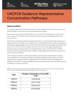
4 In winter, coastal areas are generally milder than inland. However,in cold easterly winds places on the Kent and Sussex coasts can be just as cold as inland as the short sea trackover the Dover Straits does not warm the cold continental variation of mean daily maximum and minimum temperatures month by month, together with the highestand lowest temperatures recorded, is shown for Heathrow and 'air frost' occurs when the temperature at metres above the ground falls below 0 C, whereasincidence of a 'ground frost' refers to a temperature below 0 C measured on a grass surface. The averagenumber of days with air frost in Southern England varies from less than 30 a year in London and in areasbordering the Thames Estuary and the South Coast to more than 50 a year over the higher ground. Groundfrost averages range from less than 60 days to over 110 days per year, with a similar distribution to air , those places into which cold air can drain are particularly prone to frost.
5 Examples include the plainbelow the scarp slope of the Chiltern Hills in Oxfordshire where Benson, near Wallingford, averages about 55 airfrosts and 110 ground frosts each year; here, only July and August are free of air frost and ground frost canoccur in any month. In contrast, there is an urban heat-island effect associated with London, caused by thefabric of the buildings retaining heat from day time insolation. This is most conspicuous overnight in cold spellswith light winds from late autumn to early spring, when temperatures in central London can be over 5 Chigher than in the outer suburbs and surrounding rural areas. The heat-island is also evident in summer graphs show the average frequency of air and ground frost at Heathrow and Hurn. Although near to thecoast, the topography and light soil at Hurn make it relatively prone to frost, with a ground frost possible inmost number of hours of bright sunshine is controlled by the length of day and by cloudiness.
6 In general,December is the dullest month and June the duration decreases with increasing altitude, increasing latitude and distance from the coast. Industrialpollution and smoke haze can also reduce sunshine amounts but, since the Clean Air Act of 1956 and a declinein heavy industry, there has been an increase in sunshine duration over the London area particularly in thewinter England includes the sunniest places in mainland UK, these being the coastal resorts of Sussex andHampshire. The Isle of Wight also features in the list of high sunshine averages. On the coast average annualsunshine durations can exceed 1800 hours, but 1550-1600 hours is typical of most of the region with adecrease towards the north ( less than 1500 hours over the higher Chilterns).The graphs show the average monthly sunshine totals for Heathrow and Eastbourne, together with the highestand lowest totals recorded in the stated highest known monthly sunshine total in the region is hours at Eastbourne, East Sussex in July 1911,which is a UK record.
7 In the dullest winter months, less than 20 hours have been recorded with none at all incentral London in December 1890. High annual totals include the 2237 hours recorded at bognor regis in1990, one of a remarkable series of years 1983-1991 when the West Sussex resort was the sunniest place onthe is caused by the condensation of the water in air that is being li ed and cooled below its dew tends to be associated with Atlantic depressions or with convection. The Atlantic Lows are morevigorous in autumn and winter and bring most of the rain that falls in these seasons. In summer, convectioncaused by solar surface heating sometimes forms shower clouds and a large proportion of rain falls fromshowers and thunderstorms then. The additional heat from the London urban area can encourage such showerdevelopment in further factor that greatly affects the rainfall distribution is altitude. Moist air that is forced to ascend hillsmay be cooled below the dew point to produce cloud and rain.
8 A map of average annual rainfall therefore lookssimilar to a topographic of Southern England is relatively distant from the route of many Atlantic depressions and towards thenorth-east of the region there is increasing shelter from rain-bearing SW winds. This shelter reaches itsgreatest potential around the Thames Estuary. The wettest areas are therefore the South Downs and thehigher parts of Dorset, with an average of over 950 mm per year. In contrast, the Thames Valley, London andthe north Kent coast normally receive less than 650 mm of rain per year, and less than 550mm around theThames Estuary. These values can be compared with annual totals around 500 mm in the driest parts ofeastern England and over 4000 mm in the western Scottish Highlands. Rainfall is generally well-distributed throughout the year but with an autumn/early winter maximum that ismore pronounced in counties bordering the English Channel. Further north, in London and the Thames Valley,there are also significant amounts in the summer associated with showery, convective rainfall.
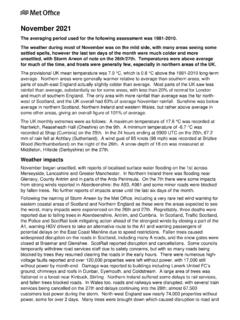
9 The course ofmean monthly rainfall for 1981 - 2010 for 4 sites is shown much of Southern England , the number of days with rainfall totals of 1 mm or more ('wet days') tends tofollow a pattern similar to the monthly rainfall totals. In winter (December to February), there are 35 to 40 wetdays on average over the Downs and the higher parts of the west, decreasing to less than 30 days around theThames Estuary. In summer (June to August) there are about 25 wet days, with the North Downs and westernareas being most of prolonged rainfall can lead to widespread flooding, especially in winter and early spring when soilsare usually near saturation. An example was the widespread inundation of the Thames flood plain in earlyJanuary 2003, following well above average rainfall the previous autumn and significant rain in late December2002. Flows on the middle reaches of the Thames were the highest since March 1947. Heavy rainfall inOctober 2000 also resulted in severe, localised flooding, with Sussex being particularly hard hit includingUckfield where homes and businesses were inundated when the River Uck burst its banks.
10 Falls included 134mm in 24 hours on 11 October at England is susceptible to summer thunderstorms, especially at inland locations. The associated highintensity rainfall can also result in flooding, but this is usually short-lived. Noteworthy examples include thestorm at Hampstead (Greater London) on 14 August 1975, when 169 mm fell in hours, and one atBracknell (Berkshire) on 7 May 2000 when 65 mm occurred in 1 hour. The intense thunderstorms that brokeout during the a ernoon and evening of the 18 July 1955 resulted in rainfalls of over 175 mm in south highest was a remarkable mm at Martinstown, near Dorchester and this is the highest daily fall everrecorded in the , the region can be subject to dry periods that place demands upon water supplies and requireconservation measures such as summer hosepipe bans. If a period with below average rainfall includes wintermonths as well as the high-demand summer months, then conditions can become severe as the winter is thenormal recharge time not only for reservoirs but the chalk aquifers upon which much of the region relies forwater supplies.