Transcription of St. Croix River 52.2R Lions Park, Lions Club of Taylors ...
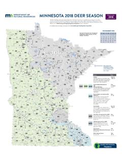
1 See map on page 29 St. Croix River Lions park , Lions club of Taylors Falls concrete plank ramp, picnic shelter, restroom Lions park , Lions club of St. Croix Falls concrete plank ramp (donation fee), dock shore fishing structure, grills, picnicking, picnic shelters, playground equipment, bench swings, restroom, trails St. Croix Falls food & lodging, Polk County Sheriff emergency 911 or non-emergency (715) 485-8300 Taylors Falls food & lodging, Chisago County Sheriff emergency 911 or non-emergency (651) 257-4100 Interstate State park , Wisconsin DNR concrete slab ramp, camping (fee), picnic tables and grills, restrooms, drinking water, no overnight mooring, Wisconsin State park vehicle (boats excluded) permit required (715)
2 483-3747, Interstate State park , Minnesota DNR camping (fee), concrete plank ramp, canoe rental, restrooms, drinking water, Minnesota State park vehicle (boats excluded) permit required (651) 465-5711, Franconia Township earth ramp - small boats only, shallow water Chisago County Sheriff emergency 911 or non-emergency (651) 257-4100 NOTE: Since 1999, the use of personal watercraft (Jet Skis, Wave Runners, etc.) has been prohibited by the National park Service north of the MN DNR Boomsite Access - at appx.
3 River Mile NOTE: Due to the possible spread of zebra mussels into the upper reaches of the St. Croix , the National park Service has restricted most boat traffic originating downstream from passing the check-26parking, one trail by River , restroomtoilets, showers, picnic area & shelter, visitor centeroater's NotesB27 point near the Arcola High Bridge (Canadian National Railroad) - mile Boaters may wish to check the National park Service s St. Croix website for more up-to-date information. Slow speed zone A special water surface use regulation is enforced on the St.
4 Croix River between the Taylors Falls dam and the Arcola Sandbar at the mouth of the Apple River . This area is designated as a slow speed zone where motorboat operation must be restricted to operating at a leisurely speed, less than planing speed, whereby the wake or wash created by the motorboat is minimal. Please obey all rules. There is also a slow - no wake rule in effect within 100 feet of all shore, including islands, and within 100 feet of swimmers. When water levels rise to 683 feet at Stillwater, a slow - no wake restriction goes into effect on the entire Lower St.
5 Croix from Taylors Falls to Prescott. Signs at public accesses and marinas will notify the public if this restriction is imposed. St. Croix River Osceola food, lodging, Polk County Sheriff emergency 911 or non-emergency (715) 485-8300 Osceola Public Access, National park Service concrete ramps, picnic area, restrooms, two picnic shelters, drinking water Fishing Pier, National park Service and Minnesota DNR pier fishing Log House Landing, New Scandia Township earth ramp, canoe & small boats only NOTE: Since 1999, the use of personal watercraft (Jet Skis, Wave Runners, etc.)
6 Has been prohibited by the National park Service north of the MN DNR Boomsite Access - at appx. River Mile NOTE: Due to the possible spread of zebra mussels into the upper reaches of the St. Croix , the National park Service has restricted most boat traffic originating downstream from passing the check- point near the Arcola High Bridge (Canadian National Railroad) - mile Boaters may wish to check the National park Service s St. Croix website for more up-to-date information. Slow speed zone A special water surface use regulation is enforced on the St.
7 Croix River between the Taylors Falls dam and the Arcola Sandbar at the mouth of the Apple River . This area is designated as a slow speed zone where motorboat operation must be restricted to operating at a leisurely speed, less than planing speed, whereby the wake or wash created by the motorboat is minimal. Please obey all rules. There is also a slow - no wake rule in effect within 100 feet of all shore, including islands, and within 100 feet of swimmers. When water levels rise to 683 feet at Stillwater, a slow - no wake restriction goes into effect on the entire Lower St.
8 Croix from Taylors Falls to Prescott. Signs at public accesses and marinas will notify the public if this restriction is map on page 3130see map on page 33 St. Croix River William O Brien State park , Minnesota DNR camping (fee), picnicking, cement slab ramp, canoe rental, restrooms, drinking water, fishing pier, trail along River bank, parking, Minnesota State park vehicle (boats excluded) permit required (651) 433-0500, Somerset Landing, Somerset Township/National park Service gravel ramp, restrooms Marine Landing, Private gravel ramp (private - not for public use)
9 , open air restaurant (open to public, call for hours) (651) 433-2864 Marine on St. Croix food, Washington County Sheriff emergency 911 or non-emergency (651) 439-9381 Marine Public Landing, Marine on St. Croix carry-in access (road not open to vehicles, but you can carry your canoe to the River .) NOTE: Since 1999, the use of personal watercraft (Jet Skis, Wave Runners, etc.) has been prohibited by the National park Service north of the MN DNR Boomsite Access - at appx.
10 River Mile NOTE: Due to the possible spread of zebra mussels into the upper reaches of the St. Croix , the National park Service has restricted most boat traffic originating downstream from passing the check- point near the Arcola High Bridge (Canadian National Railroad) - mile Boaters may wish to check the National park Service s St. Croix website for more up-to-date information. Slow speed zone A special water surface use regulation is enforced on the St. Croix River between the Taylors Falls dam and the Arcola Sandbar at the mouth of the Apple River .