Transcription of Sugarloaf Mountain
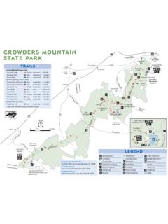
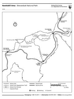
1 Sugarloaf Mountain STRONGHOLD INCORPORATED. C I RCU I T H I K ES 7901 Comus Road, Dickerson, MD 20842 301-874-2024. 301-869-7846. B L U E ( B). Northern Peaks Trail Starts at West View parking #. i l P2. 5 miles of nice scenery and hiking. e Tra 500 rpl 800. Pu P U R P L E (P). Alternate route to White Rocks. 60 0 90 0 600. By itself, miles. As an alternate to blue , l 700 rai adds 1/2 mile to total distance. eT 1015'. Blu WHITE White B. Mountain Loop Trail Rocks #. P3 ". 4. 6 #. P1. 80. 0. 70. 0. A 2 1/2 mile loop around the summit. 895' B. ". 5. Add to the Northern Peaks Trail 800. Y!7. 70. for 7 miles. 0. il Y E L L O W ( Y) Tr a Y!8. B. 0. Saddleback Horse Trail " ow 80. 0. 70. 7. 0. ll 60. 0. B. Ye ". 50. il A 7 mile loop around the base of the 4. a Tr Mountain . Open to horses and hikers ! Y6. ue !9. Y. Bl year round. Open to bicycles Memorial Day through Labor Day. 995'. 600. il Tra B lue 900. See other side for detailed map of summit area. 70. 0. B ! Y5. ". 3. "B 0. 80. 8.
2 0. ! Y4. 80. l ! Y10 0. ai 90. Tr w l lo Ye 0. 70. 600. d 00. im R. 10.. Y!3. blue Trail 1071'. phra B. " 700. nt E. 2. 600. 0. Mou 80. ! Y11. B. " a il 9 Tr te hi ! W. 0. Y12. 70. 0. 60. 700. 0. 80. W. ail B tain Rd hi Tr "1 f Moun ls te a lue Sugarlo i ! Y2. Tra Tr B. a il ite ail Wh Tr d Re A. I. e&. Or il an a Blu 1282'. Tr ge Yel l rai w W Water Tr lo low nT. l a Ye B ee il Gr ". A. Tra 10 Parking, toilets 0. 1000. 50. il A. I. White Trail ! Y1. A. I ail Summit locations 1282' and elevations Tr ! te Y13 hi W 50 B Signpost locations 0 7 and numbers. 0. 60. Placed at about Y9 1/2 mile intervals il Strong Tra Mansion on the blue , Yellow P3 and Purple trails. ite Westwood Wh Mansion Remember the color and 500 ! Y14. number of the last signpost you s Rd Comu passed, in case you get lost. Horse Trailer Parking Turner 500. Farm E NTRANCE AW. I Comu s Rd 2009 Cartography by Diana Todd 0 1. 0 50. 50 0 miles Sugarloaf Mountain STRONGHOLD INCORPORATED. Sugarloaf Mountain , a conservation/recreation area, is NATURAL HISTORY.
3 Privately owned and managed by Stronghold, Inc. Visitors Geologically, Sugarloaf is known as a monad- are invited to participate in the wide variety of outdoor nock, a Mountain that remains after the erosion of recreation pursuits that include hiking, horseback riding, the surrounding land. Here, that process took picnicking and nature study. The Mountain is open every approximately 14 million years. At an elevation of day of the year from sunrise to sunset. Darkness can come 1282 feet, Sugarloaf stands more than 800 feet quickly on the Mountain , so all visitors should arrange to above the farmland below. The rugged cliffs on the be off the property by sunset. Please remember, all natural summit are composed primarily of quartzite, the features are protected. Do not pick plants, disturb wildlife, predominant type of rock on the Mountain . or remove rocks. Dogs must be on a leash at all times. Fires The dominant tree species on Sugarloaf are the and overnight camping are strictly prohibited.
4 Alcohol is oaks of both red and white groups. These trees are not permitted. Carry a cell phone if possible. being threatened by oak decline, a result of several factors of which the introduced gypsy moth is a part. Other trees include black gum, tulip poplar, McCormack Overlook black birch and eastern hemlock. The more than 500 species of plants include a variety of wildflow- ls il 0. i a 70. Tra Tr 800. lue ers, many of which can be found blooming during ite B. Wh the warm weather months. 0. 90. il e&. a W. Whitetail deer are abundant on and around the Tr hi Blu d te Re Tr Mountain . Other mammals include flying squirrel, A. I. ail Or 1282'. red fox, eastern cottontail and raccoon. The forest an 0. ge 90. West l i 1200 birds include the great horned owl, pileated wood- Tr View Tra a n il ree 11 00. pecker, wild turkey and red shouldered hawk. 0. 80. G. 1000. During the spring and fall, many migratory species A. 0. East of songbirds can be found. l 70. e Trai View A. I PLEASE be aware that this is the habitat of the Whit Potomac Overlook timber rattlesnake and the copperhead.
5 LOOK! 0. il 60. a Tr hite BUT DO NOT TOUCH!! W. Trail Blazes Summit Area Trails Strong Color indicates the trail GREEN. il Tra Mansion you are on. Thomas Trail ite In some places, the White A 1/4 mile improved trail to the Wh Westwood trail uses the same path as summit. The stone steps were Mansion the blue or Yellow trails. built by Mr. Thomas, Stronghold's first superintendent. A double blaze means & Rd ORANGE. llow e Com us a junction or sharp turn Ye it is just ahead. The Sunrise Trail Wh A steep 1/4 mile to the top. 500. Multipurpose trail. RED. A. I The Monadnock Trail Spur trail. Connects point Leaves the Northern Peaks ( blue ). 0 500 1,000 1,500 2,000 2,500. of interest to nearby trail. trail for a 1/4 mile hike to the summit. Feet