Transcription of Thames Path north bank route ... - Transport for …
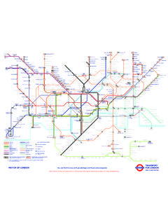
1 Transport for Thames path north 3 of 4. Tower Bridge to Island Gardens. Section distance: 5 miles (8 kilometres) .Introduction This five mile section of the Thames path National Trail follows the river eastwards on the north bank below Tower Bridge to the Isle of Dogs, in the distinctive bend of the river that features on many london maps. Tower Bridge is the last bridge crossing before the Queen Elizabeth II Bridge at Dartford, but the river can be crossed under by the Greenwich and Woolwich foot tunnels, the former on the Isle of Dogs, where the Thames path National Trail officially ends (but see section four for the extension as far as East India Dock). Section start: Tower Bridge. Nearest stations to start: Tower Hill , Tower Gateway , Fenchurch Street or Tower Pier .Section finish: Island Gardens.
2 Nearest stations to finish: Island Gardens . The riverside along this stretch has changed from predominantly industrial to mainly residential, with a mix of converted warehouses and new apartment blocks. The sense of history is still palpable and the views are superb. Pass the places where pirates hung in chains; where Turner painted, and Dickens set many of his scenes; where Isambard Kingdom Brunel tasted his first success and most bitter setbacks; and where dockers once grafted. The walk traces the rise, decline and regeneration of london 's great docks, which bore the brunt of the Blitz in the Second World War. Warehouses have since been converted to apartments, and cafes and new housing now line once-busy wharves. Contemporary life has also made its mark in the striking form of Canary Wharf, the Thames Barrier and the O2 Arena (originally known as the Millennium Dome).
3 Directions Turn left out of Tower Hill station and then right to cross the road (note: section of the old city wall on the left). Turn left along the side of the Tower moat and follow the signs to St. Katharine Docks and Tower Bridge to the start of the walk. Pick up the Thames path at St. Katharine's Pier, at the foot of the Tower Bridge on the north -east side of the Thames . Passing the water sculpture of Girl with a Dolphin, cross the footbridge at the entry to St. Katharine Docks. Did you know? A hospital, medieval church and many houses were demolished to make way for the docks, built in 1828. Goods as various as tea, rubber, wool, marble, sugar, tallow and ivory were imported here and stored in the tall warehouses. Note the narrow entrance; not able to accommodate very large ships which contributed to the dock's decline.
4 Abandoned after World War II, the docks were revived in the 1970s to house offices and apartments, restaurants and shops, set around a lively marina. It is still home to traditional Thames sailing barges. Bear right after the footbridge along the pedestrianised edge of the dock, and then right before the Dickens Inn to exit into St. Katharine's Way. Walking down this road, look out on the right for a sign pointing between buildings to reach the Thames again for a short stretch. Make a small detour round the inlet, back to the road at the junction with Stockholm Way. Carry on to the right along what is now Wapping High Street, a quiet cobbled street with some fine traditional riverside pubs. The Thames can be joined again immediately after the inlet, by walking through Hermitage Gardens. Soon, near Wapping Old Stairs, make another small detour back to Wapping High Street and there turn right.
5 Did you know? Wapping Dock first appears on a map made around the time of the Great Fire of london in is The Town of Ramsgate pub, a 15th century ale house, one of the 36 pubs which once served Wapping High Street. It takes its name from the fishermen of Ramsgate who landed their catch at Wapping Old Stairs, still found at the end of the alley beside the pub. Carry on along Wapping High Street. The next landmark is the pleasant Waterside Gardens at Wapping Stairs. Did you know? This is the most likely site of Execution Dock, where pirates received the 'Grace of Wapping' - tied to a stake until the tide had washed over them three times. Captain Kidd, a naval officer turned pirate, shared this fate in 1701. His name lives on in the Captain Kidd pub nearby, in a converted warehouse entered via a courtyard.
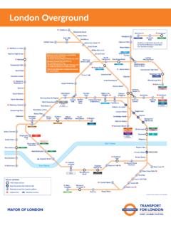
6 Just after Wapping Overground station look for a gated ramp on the right-hand side between buildings - which is a way to reach the Thames again. This short stretch of riverside walk is called St. Hildas Wharf. At the end, go back to the street which makes a bend and becomes Garnet Street. At the primary school turn right along Wapping Wall to continue the walk. Another tempting pub stop is The Prospect of Whitby just before Shadwell Basin, with its long bar, wood fires and balcony onto the river. Did you know? Once a hotbed of cockfights and bare knuckle fights, the pub was a haunt of thieves and smugglers, but also a favourite vantage point for Whistler and Turner, who painted some of their most famous riverside scenes from here; it was also a regular drinking place for Charles Dickens and Samuel Pepys.
7 Turn right along the path by the side of the Prospect of Whitby to the river and walk around Prospect Wharf, re-joining Glamis Road where a red bridge crosses the entrance to the wharf. The bridge is a bascule - moved by a counterweight - and marks the entry to Shadwell Basin, built when ships first outgrew the Pool of london , and now an attractive setting for waterside housing and watersports. After the bridge, turn almost immediately right up a footpath leading back to the waterfront, through King Edward Memorial Park. The rotunda at the entrance is a ventilation shaft for the Rotherhithe Tunnel, designed by Sir Maurice Fitzmaurice, engineer to the london County Council. The Rotherhithe Tunnel links Tower Hamlets to Southwark. Take a short detour away from the Thames , by turning right into Narrow Street.
8 Then to reach the river again, turn right just after Sun Wharf. Carry on along the riverside to the panoramic viewpoint of The Narrow pub, at the entrance to Limehouse Basin. The pub was the old Dockmaster's House as Limehouse Basin is a link to England's canal network. Cross the bridge at Limehouse Marina and immediately turn right to reach the Thames again. After one block make a detour back to Narrow Street and carry on, past 18th century merchants' houses to The Grapes pub: named as 'The Six Jolly Fellowship Porters' in the Dickens' novel 'Our Mutual Friend'. It still has a wonderfully Dickensian feel. From Narrow Street, follow signs through the arched entry to the waterfront at Duke Shore Wharf. Follow the Thames path as it heads south along the distinctive bend of the river that defines the Isle of Dogs; an influx of lunch-time joggers announces the approach of Canary Wharf, one of london 's financial centres.
9 There is a pier here regularly served by Thames Clipper boats. Did you know? The first Canary Wharf skyscraper, with a pyramid tower, is called ''One Canada Square'' and was the tallest habitable building in Britain at 244m high until the completion of The Shard at london Bridge. Curve around Westferry Circus. Go straight down Westferry Road and turn right after about 40 yards to rejoin the riverside path . Continue south beside the Thames , passing apartment blocks and through Sir John McDougal Gardens. At Arnhem Place make a detour, past Anrhem Wharf Primary School and turn right on to Westferry Road. Pass the Docklands Sailing and Watersports Centre on the left in the old Millwall Dock, and continue along Westferry Road. Go past a church which is now called 'The Space' and used for performing arts.
10 Just after another primary school on the left and before Spindrift Avenue, look out for a Thames path sign to turn right down Masthouse Terrace. Did you know? The history of this area is ship building. Masthouse Terrace was where Brunel's 'Great Eastern' was launched sideways in 1858 - the ship was twice the length and five times the weight of any previous ship. It was intended to take passengers non-stop to India and Australia but instead laid the first transatlantic telegraph cable. Walking along the waterfront again, pass a mix of old and new housing. Just past Maritime Quay there is a new pier at the end of Napier Avenue. Carry on along Blasker Walk all the way to a Thai restaurant called 'Elephant Royale' at Locke's Wharf. Turn left inland through the car park here to face The Ferry House pub (there was once a ferry crossing here).