Example: confidence
THE ACCURACY OF USING THEODOLITE IN CLOSE …
THE ACCURACY OF USING THEODOLITE IN CLOSE-RANGE ENGINEERING MEASUREMENTS Hüseyin Gazi BAŞ University of Sakarya Engineering Faculty Department of Civil Engineering
Tags:
Information
Domain:
Source:
Link to this page:
Documents from same domain
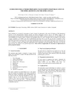
GUIDELINES FOR AUTHORS PREPARING …
www.isprs.orgguidelines for authors preparing manuscripts for publication in the isprs archives and the isprs annals . m. o. altan 1, g. toz 1, i. dowman 2, s. kulur 1, d. z. seker 1, p. löwe 3 c. heipke 4,

THERMAL REMOTE SENSING: CONCEPTS, ISSUES …
www.isprs.orgInternational Archives of Photogrammetry and Remote Sensing. Vol. XXXIII, Part B1. Amsterdam 2000. 239 THERMAL REMOTE SENSING: CONCEPTS, ISSUES AND APPLICATIONS

What is Remote Sensing?
www.isprs.org2 What is Remote Sensing ? “Remote Sensing is defined as the science and technology by which characteristics of objects of interest can …

Introduction to GIS (Basics, Data, Analysis) Case …
www.isprs.org1 Introduction to GIS (Basics, Data, Analysis) & Case Studies 13th May 2004 Content • Introduction to GIS • Data concepts • Data input • Analysis • …

HIGH (SPATIAL) RESOLUTION vs. LOW …
www.isprs.orgMahavir, Dr International Archives of Photogrammetry and Remote Sensing. Vol. XXXIII, Supplement B7. Amsterdam 2000. 127 HIGH (SPATIAL) RESOLUTION vs. LOW RESOLUTION IMAGES :
SOIL EROSION MODELLING BY USING GIS & …
www.isprs.orgSOIL EROSION MODELLING BY USING GIS & REMOTE SENSING : A CASE STUDY, GANOS MOUNTAIN Berk Ustun a, ∗* a ITU, Civil Engineering Faculty, 80626 Maslak Istanbul, Turkey-(e0727619@student.tuwien.ac.at) KEY WORDS: Environment, GIS, Hazards, Land Cover, Prediction, Vegetation, Monitoring ABSTRACT: This paper …
COMPETENCY STANDARDS - A MEASURE OF THE …
www.isprs.orgCOMPETENCY STANDARDS - A MEASURE OF THE QUALITY OF A WORKFORCE John C Trinder School of Surveying and SIS, The University of New South Wales, UNSW SYDNEY NSW 2052, Australia
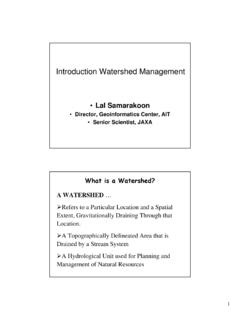
Introduction Watershed Management
www.isprs.org1 Introduction Watershed Management • Lal Samarakoon • Director, Geoinformatics Center, AIT • Senior Scientist, JAXA A WATERSHED … ¾Refers to a …

LIDAR- DATA: AUTOMATIC OBJECT DETECTION …
www.isprs.orgLIDAR- DATA: AUTOMATIC OBJECT DETECTION TO SUPPORT URBAN FLOODING SIMULATION MD. Aktaruzzaman, Theo G. Schmitt Institute of Urban Water Management, University of Kaiserslautern, Paul Ehrlich strasse 14,

2. Differences between maps and images.
www.isprs.org2. Differences between maps and images. There are typical differences between maps and images, originating from the distinctions about the aim of data gathering, the acquisition technique, the data processing and the
Related documents
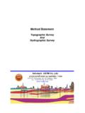
Topographic Survey And Hydrographic Survey - i …
www.i-astm.comASTM Testing Co., Ltd. 2 - Minimum number of direction observations with a one-second theodolite: 4 positions of circle. - Differential leveling-loop closure not to exceed 0.008 m
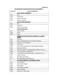
LIST OF MAJOR CONSTRUCTION PLANTS & …
enlist.eil.co.inAnnexure-III LIST OF MAJOR CONSTRUCTION PLANTS & EQUIPMENTS CODE NO. CODE DESCRIPTION EARTH MOVING EQUIPMENT: 0101 Dozer 0102 Wheel Loader 0103 Hydraulic Excavator
CIVIL ENGINEERING UNIT 1: ENGINEERING …
trb.tn.nic.inCIVIL ENGINEERING UNIT 1: ENGINEERING MATHEMATICS Linear Algebra — matrix algebra, linear equations, - eigen values and eigen vectors. Calculus- Functions of single va riable, limit, continuity and differentiability - mean value
www.allindiaradio.gov.in
www.allindiaradio.gov.in(2) 13. This information is also available on AIR net. www.allindiaradio.gov.in 14. Site may be visited for work assessment before quoting. 15.
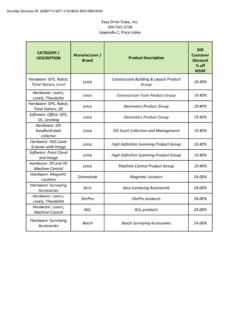
DIR Customer DESCRIPTION Product Description …
www.easydrivestake.comEasy Drive Stake, Inc. DIR-TSO-3738 Appendix C, Price Index CATEGORY / DESCRIPTION Product Description Manufacturer / Brand DIR Customer Discount
49 - Food and Agriculture Organization
www.fao.org49 5. Hydrographic surveys SUMMARY In the past, many artisanal shelters and fishing ports were built at convenient locations, with no particular attention paid to such environmental factors as
West Bengal Housing Infrastructure Development …
www.wbhidcoltd.comWest Bengal Housing Infrastructure Development Corporation Limited (A Govt. of West Bengal Undertaking) HIDCO BHABAN, Premises No. - 35-1111, Biswa Bangla Sarani,