Transcription of The Chart Clinic – First in a Series - Craig Morton
1 The unequal distribution of facilities, the enroutecharts use different scales for Chart depiction. Mostof the scales used for the US are 1 = 10 NM,although a few of the charts use the scale of 1 =20 NM. But, let s not get too academic. The realreason for mentioning scale is a reminder thatwhen eyeballing distances on charts, an inchmay represent five minutes on one Chart and twoand a half minutes on another Chart . This can bedeveloped into a rule of thumbnail: Assuming your aircraft flies 300 knots, eachnautical mile goes by in .2 minutes. This meansthat a thumbnail measurement on the 20NM scale Chart takes 3 minutes; on the 15 NMscale, a thumbnail takes 2 minutes; on the10 NM scale, a thumbnail takes Even though the distances are printedon the charts, there are many times when it isnice to know quickly how far an airport is off anairway, or your time to an LayoutA large 81/2 x 11 foldoutpage in the front of eachenroute Chart bookshows the layout of thelow altitude enroutecharts.
2 An excerpt ofthis illustration isalso on the frontpanel of eachenroute chartoutlinesshownbyheavylines indicate thegeographical location ofthe shaded areas found on the front panel areused to depict the locations where area charts areprovided. Because of some of the hot spots mentioned earlier, it is necessary to provide areacharts with a larger scale to show more detail withless clutter in some of the major terminal are 18 area charts in the US for these hotspots, using the scale of NM to the inch onmost charts are considered enroute charts andtherefore are located with the enroute charts inyour shipment. When you receive an AirwayManual service, however, we recommend thateach area Chart be removed from the enroutechart location and filed with the appropriate keeps the area Chart near the approachcharts, SIDs and STARs and provides a betterterminal package when operating to or from large CycleIf you owned your own VORTAC station and foundwhen tuning to its frequency that you werereceiving interference from a neighboringVORTAC, your First reaction would be to changeyour neighbor s VORTAC frequency (or your own),effective tomorrow.
3 However, that wouldn t allow enough time to distribute the new VORTAC frequency to all users of the nationalairspace solve this type of problem, the InternationalCivil Aviation Organization (ICAO) membernations have agreed that at least 42 days ofadvance notice will be given when majoraeronautical changes are made. Not only is theadvance notice required, the effective date must fall on day 1 of a 28-day cycle. Most of the 184 ICAO nations have agreed tothis same cycle. Changes to theenroute charts are effective 0901Z on day 1, which always falls on high and low altitude enroute charts inthe United States and Canada are revised using every other 28-day cycle.
4 During somecycles there are no changes to the enroutecharts; but even if no changes are made to anenroute Chart , it is reprinted and distributed everytwo to three Text PagesBefore looking at the enroute Chart symbols, let slook at some of those front pages at thebeginning of the enroute manual. Each text pagehas a name centered at the top indicating thesection to which it belongs. These names matchthe tab pages, which are used as dividers. Inaddition to the section name, a page number isfound in the upper left or right corner. If the pagenumber is US-8, for example, that page wouldbe found only in the United States Airway the page number is not prefixed with letters,then that page is an international page and isincluded with all Airway Manual studying the legend pages and chartsymbols, it helps if you understand that they areinternational in nature and description.
5 Thistechnique allows US pilots to use internationalcharts and non-US pilots to use US charts withoutThe Chart Clinic First in a SeriesWhen you think of IFR charts, approachprocedures, MEAs, MOCAs and themyriad of other associated acronyms,you hardly think of the type of reading materialyou would snuggle up with near a fireplace on acold, winter evening. No one would confuse Fateis the Hunter, Overflight, or Bombs Away, with the legend pages of the Airway Manual!This Series of articles is written so that pilots can getthe most value from their Jeppesen AirwayManuals. Most of the charts and symbols are veryfamiliar, because you use them on every trip.
6 Otherpages are read less often than the telephone using an IFR service, all materials can belumped into one of two categories enroute orterminal. The enroute operations use low altitudeenroute charts, high altitude enroute charts, areacharts, or RNAV/GPS enroute charts. Terminaloperations normally use approach charts, standardinstrument departures (SIDs) (soon to be calleddeparture procedures (DPs), and standardterminal arrival routes (STARs). The openingsubject of this Series will be enroute ChartsThe First enroute charts used by most pilots are thelow altitude enroute charts which portray theVictor airways. These low altitude airways are usedin the airspace between the minimum usable IFRaltitude up to 17,999 MSL.)
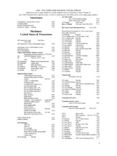
7 The high altitudeenroute charts display the Jet airways, which beginat 18,000 MSL and proceed up through FL cover the entire United States with low altitudeenroute charts, there are 52 charts, even though asubscriber to the full US coverage doesn t getevery one of the 52 charts. These charts arelabeled at US(LO)1/2 through US(LO)51/52. Itwould be simple to design a Chart Series to coverthe entire United States if our population weredistributed equally throughout all thegeographical coverages. Unfortunately, certain hot spots, such as New York City, Miami, Dallas,and Los Angeles, attract large masses of centers also require large masses of VORsand airways, condensed in small areas.
8 Because ofBYJAMESE. TERPSTRA learning new symbols or abbreviations. Forexample, the letters CTR are used to indicate acontrol zone rather than the Letters CZ whichseem to make more sense. The letters CTR arethe official ICAO abbreviation for control pages found in the front of the enroutechart binder include: Air Defense Identification Zones Florida Keys Free Area In Flight Weather Advisory Reference Locations Stratification of United States Airspace System High Density Traffic Airports Preferred IFR Routes Tower Enroute Control (TEC) City PairsThe list above is a reminder to refer to those pagesoccasionally. This will help you keep current onsome of the seemingly trivia items that havebeen forgotten since ground school important section is the ChartNOTAMs.
9 The Chart NOTAMs are includedbehind their own tab. These pages are revised andreissued every two weeks. Pertinent NOTAMs(longer than the daily NOTAMs) in the nationalairspace system are included in the revision noticepages. The NOTAMs listed in the enroute sectionare appropriate to the enroute charts and arelisted by the Chart on which they are of facility shutdowns, changes offrequency, and temporarily unusable navaids areJames E. Terpstra is seniorcorporate vice president, flightinformation technology atJeppesen. His ratings includeATP, single and multi-engine,airplane and instrument flightinstructor. His 6,000+ hoursinclude 3,200 instructing.
10 For comments, please in the revision notice. Changes to thesepages are indicated with a large arrow on the leftside of the NOTAM information. These pagesshould be reviewed before every though the legend pages aren t recreationalreading, we recommend that you spend a fewhours on the next layover reading those enroute Jeppesen AirwayManual, the original, theclassic that instrument pilots worldwide havedepended on for over 60 years, is now availableon call it JeppView. And it gives you thepower, convenience and reliability of Jeppesencharts on a single compact disc, ready to colorful, high-resolution Chart displayis as close as your Windows-based PC. Plus, JeppView s robust print-on-demandcapability lets you printwhatever you need, from asingle Chart to an entire trip JeppView CD-ROM includes JeppesenApproach Charts, SID, STAR and AirportCharts along with airport information,legend and Chart NOTAMS, plus paperEnroute and Area find out more, or to subscribe to JeppView, call 800 -621-5377 or 303 -784 -4274(US), +49 69 96 12 48 51 (Germany).