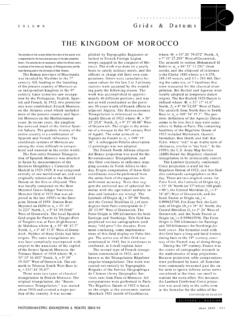
Transcription of THE KINGDOM OF NORWAY - ASPRS
1 C O L U M N Grids & Datums THE KINGDOM OF NORWAY . The contents of this column reflect the views of and alidade without basic control have it engraved and printed in Paris the author, who is responsible for the facts and were inevitably deemed unreliable. at their own expense. In 1833, the accuracy of the data presented herein. The con- In January of 1779, General Von organization's name was changed to tents do not necessarily reflect the official views Huth directed that subsequent map- Norges Geografiske Oppm ling (Geo- or policies of the American Society for Photo- ping be based on astronomically de- graphical Survey of NORWAY , or grammetry and Remote Sensing and/or the Uni- termined points and classical trian- NGO).
2 By 1854, NGO obtained the versity of New Orleans. gulation surveys. Initial longitude expertise and equipment to publish NORWAY was settled in the Middle determinations were based on fire their own maps. The first series of Stone Age (circa 7000 ), and by signals, gunpowder explosions, and published maps were cast on the the 9th century , the Norse expe- pendulum clocks. This was found Cassini-Soldner projection and were ditions began which colonized the too inaccurate, and in the winter of referenced to the Svandberg 1805 el- islands off Scotland, Ireland, Ice- 1779-1780, a baseline was measured lipsoid where the semi-major axis land, and Greenland. Trondheim was on Lake Storsren using wooden sur- (a) = 6,376, meters and the re- the Norwegian capital until 1380.
3 Vey bars. By 1784, a triangulation ciprocal of flattening (1/f) = Kristiania, founded in 1050, became arc was surveyed between Presumably, this was based on the the capital in the 14th century and Kongsvinger and Verdal. Additional Oslo Observatory Datum (of 1810?). was renamed Oslo in 1924. The King- triangulation work continued, and where: Fo = 59 54' North, dom occupies the western part of the the survey was adjusted in 1810. L o = 10 43' East of Greenwich. Scandinavian Peninsula. It is The geographical position of Bergen However, the defining azimuth to bounded on the west by the Atlantic was compared to another determi- Husbergoen was not observed until Ocean, on the north by the Arctic nation from a triangulation arc from 1869.
4 The sheets had no printed Ocean, on the north east by Russia Lindesnes. The difference in longi- grid, and were cast on the graticule and Finland, on the east by Sweden, tude was 9 and that error was con- such that they measured 20' of lati- and on the south by the Skagerrak sidered satisfactory at the time. tude and 1 of longitude. The sheets and Denmark. Because of the numer- From 1791 to 1803 a series of hy- started at 58 North and were evenly ous fjords and small coastal islands, drographic charts were published spaced longitudinally from Oslo Ob- the KINGDOM has one of the longest from the surveys of Lt. F. C. Grove servatory. This lasted until 1844. coastlines in the world. NORWAY of the Royal Danish Navy.
5 Printed when the ellipsoid was changed to claims the islands of Svalbard and in Copenhagen from copper plates, the Bessel 1841, and then the series Jan Mayen in the Norwegian Sea. the Grove Charts were used for was continued through 1890. This The earliest modern map of Nor- navigation for about 100 years. strange series of map sheets was ac- way was the map of Scandinavia A re-organization of surveying and tually a common design for the time. drawn by Claudius Clavus in Italy mapping within the government in (The Grove Charts were based on the about 1425. Several other maps were 1805 combined military and eco- Cassini-Soldner projection also). In compiled of the entire peninsula, but nomic objectives in the same depart- 1891, the Cassini-Soldner projection the first national cartographer of ment.
6 The Norske Topographiske was replaced by the polyhedric pro- NORWAY was Melchoir Ramus who Oppm ling (Norwegian Topographic jection. As I have pointed out in past mapped the southern coast from Survey, or NTO) passed among sev- columns, the polyhedric is math- 1689 to 1693. German foresters were eral ministries including Defense, In- ematically equivalent to the system employed in the eighteenth century terior, Finance, Customs and Trade, commonly used for computational to map the land resources of the and finally back to Interior. In 1823, photogrammetry, which is the local KINGDOM after the Scandinavian all operating funds were suspended. space rectangular. The equiva- wars. The excellent quality of the The first 50 years of survey and map- lent was merely based on a different work and the need for military maps ping work had not been reproduced aphylactic projection, the polyconic.
7 Of NORWAY after the many years of in large quantities because maps Prof. Hamsteen became the new war with Sweden prompted the estab- were generally considered a military director of the survey in 1832, and a lishment of the Norges Gra ndsers secret. The first map printed was a new triangulation commenced in Oppm ling (Norwegian Border Sur- county map of Smaalenenes that was 1834 from Kristiania (Oslo) to vey) on 14 December 1773. Attached published in 1826 at a scale of Trondheim covering most of south- to the military, the initial attempts of 1:200,000. In fact, two of the NTO ern NORWAY . The Russian-Scandina- the NGO at mapping by planetable surveyors obtained permission to CONTINUED ON PAGE 1130.
8 C L I F F O R D J . M U G N I E R , , PHOTOGRAMMETRIC ENGINEERING & REMOTE SENSING O c t o b e r 19 9 9 1129.. Grids & Datums C O L U M N. CONTINUED FROM PAGE 1129. vian geodetic survey extended from Swedish Lapland to Fuglenes at Hammerfest in NORWAY from 1845-50. The Fuglenes Datum of 1850 origin is where: Fo = 70 40' North, Lo = 23 40' East of Greenwich. The ellipsoid of reference is the Bessel 1841, but some of the original manuscript computations must surely be on the Walbeck 1819, which was the standard for the Russians at that time. The defining azimuth was to station Jedki. By 1874, the NGO was transferred from the General Staff to the Army Department. The Triangulation Division started a second-order triangulation in 1880, and adopted a network adjustment philosophy in 1903.
9 Com- putations in geodetic coordinates were introduced in 1891. The Gauss-Kr ger Transverse Mercator system for NORWAY was initiated in 1916 and is based on the Oslo Observatory Datum of 1844. The ellipsoid of refer- ence is the Bessel 1841 where the semi-major axis (a) = 6,377, meters and the reciprocal of flattening ( 1/ f) = Terrestrial photogrammetric experiments started in 1907, and phototheodolites were purchased in 1910. In 1920, a Zeiss Stereoautograph was purchased for the com- pilation of terrestrial photography, although the plane table and alidade was still used to supplement detail for holidays in the photo coverage. All topographic mapping was performed with aerial photographs after 1933.
10 By 1936, a Zeiss C-1 Universal Stereoplanigraph was in pro- duction at NGO. The military Grids used for NORWAY through World War II were the Northern European Lambert Conformal Conic Zones I-III. These were complicated systems that had Grid boundaries defined by other Grid systems, by the graticule, and by numerous ellipsoidal loxodromes. Although easy to compute nowadays, these Grids were part of the nightmare for Army Topographic Engineers in the 1940s. After WW II, the Oslo Observatory Datum of 1844 was transformed to the European Datum of 1950 (ED50). through the Northern Block Adjustment of 1949-51. The Coast & geodetic Survey performed the computations on the International Ellipsoid where: a = 6,378,388.