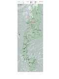
Transcription of Thornton Gap Area - Shenandoah National Park S Department ...
1 2/2020 Thornton Gap Area - Shenandoah National ParkA map of the Thornton Gap Area in Shenandoah National Kilometer0MP30MP31MP32MP33MP34 Buck Ridge TrailBuck Hollow TrailLeading Ridge TrailRocky Branch TrailPass Mountain Trail Hazel River TrailWhite rocks TrailThornton GapTunnelOverlookBuck HollowOverlookHazelMountainOverlook MeadowSpringTrailPass Mountain Hut Fire RoadPass MountainOverlookPass MountainLoop TrailPass Mountain HutHazel Mountain TrailUS211US211US211 NorthMary s RockSummitMary s Rock TunnelByrds Nest 3 ShelterEntrance StationRestroomsEmergency 1-800-732-0911 Information 540-999-3500 Online Hiking Trail Hiking Trail (Appalachian Trail) Hiking Trail (Horses) Unpaved Road Paved Road Skyline Drive Park Boundary StreamP Parking Building Viewpoint National Park Department of the InteriorMarys Rock Summit Hike round trip hiking time Moderate 1,210-foot elevation gainFrom the trailhead at the back of the Panorama parking area at mile , take the short connector trail to the Appalachian Trail and go left (south).
2 At the trailpost take a right to the viewpoint. Retrace your steps. Marys Rock Summit Hike Alternate round trip 3-hours hiking time Moderate 830-foot elevation gainFrom Meadow Spring parking area at mile , cross Skyline Drive and take the Meadow Spring Trail to its intersection with the Appalachian Trail ( ). Go right onto the and follow it to the next trailpost. Go left to the viewpoint. Retrace your Mountain Loop Hike round trip hiking time Moderate 670-foot elevation gainFrom the trailhead at the back of the Panorama parking area at mile , take the short connector trail to the Appalachian Trail ( ) and go right (north). Cross Route 211 and Skyline Drive. Go right onto the fire road and follow it to the hut. There, look for the blue-blazed Pass Mountain Trail and take that back to the south which will take you back to your starting point.
3 Hazel River Falls Hike round trip 5-hours hiking time Moderate 1,070-foot elevation gainFrom Meadow Spring parking area at mile , take the yellow-blazed Hazel Mountain Trail past the Buck Ridge Trail. At the fork, go left onto the yellow-blazed White rocks Trail. At the next trailpost, go right and continue to see two small waterfalls. Retrace your steps back to the parking & BlazesTrail markers are at trailheads and intersections. The metal bands are stamped with directional and mileage information. Trail blazes are found on trees and rocks throughout the Park. The color identifies the trail type:Blue - Hiking trailWhite - Appalachian TrailYellow - Open to horsesNeed to Know Pets must be on a leash no longer than 6 feet at all times. Be sure you are physically able to complete the hike you ve chosen.
4 Take plenty of water at least a quart per hour. When you return from your hike, check for ticks. Be sure someone knows where you are and when to expect your return. Stay on the trail and avoid trampling sensitive vegetation Cell and GPS services are to KnowWhen hiking in Shenandoah , it s always good to stay on the trail for your safety and for the protection of the natural and cultural resources. On Marys Rock, it s particularly important! Fragile plants and lichens thrive in these rocky places. Take in the expansive views, but don t forget to notice what s underfoot to avoid crushing fragile plants and lichen!Fun to KnowLike many of the Park trails, Marys Rock Trail was built by the boys of the Civilian Conservation Corps (CCC). While you re at the Park stop by Byrd Visitor Center (mile 51) to learn more about these young men who made Shenandoah what it is today!
5 Hiking Difficulty ScaleEasiest: Generally suitable for anyone who enjoys walking. Mostly level or with a slight incline. Generally less than 3 : A moderate hike generally suitable for novice hikers seeking a bit of a challenge. The terrain will involve a moderate incline and may have some steeper sections. Generally 3 to 5 Strenuous: Generally challenging for an unconditioned person. The terrain will involve a steady and often steep incline. Generally 5 to 8 : Will challenge most hikers. The hike will generally be longer and steeper, but may be deemed strenuous because of the elevation gain. Generally 7 to 10 Strenuous: Only well conditioned and well prepared hikers should attempt. Generally long and steep, and may include rock scrambling, stream crossings, and other challenging terrain. Generally 8 miles and maintenance and map funded by recreation fee dollars.