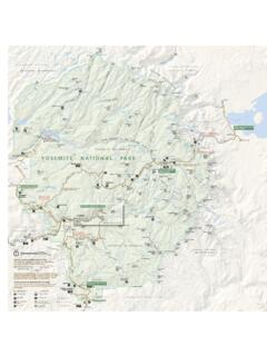
Transcription of Tioga Road - National Park Service
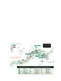
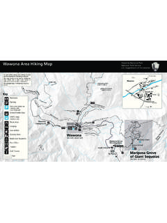
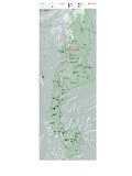
1 Tioga road (from Crane Flat to Tenaya Lake). Day hikes and overnight trips are abundant along the Tioga road , each with a scenic reward of its own. Trips available from this stretch of the Tioga road range from relatively level forested hikes to Yosemite Valley's north rim to trails plummeting deep into Yosemite's northernmost canyons. (The Tioga road closes due to snow, usually from sometime in November through late May or early June. There is no overnight parking on the Tioga road after October 15; please plan accordingly.). Trail Descriptions and Distances (One Way). Tioga road Tamarack Flat white Wolf Campground This trail provides access to the north rim of Yosemite Valley A pleasant trail through red fir forest with access to different with pleasant hiking through mixed conifer forest.
2 Lake basins and the Yosemite Creek watershed. Miles Km. Miles Km. Old Big Oak Flat Lukens El Ten Yosemite Falls (top).. May Yosemite North Lukens Lake->Yosemite Creek Yosemite Valley (via Snow Creek).. This trail descends through the forest to the slick granite South Fork Tuolumne River Yosemite Creek watershed. Miles Km. This trail winds through old burn areas and mixed conifer Yosemite Creek Campground forest and can sometimes be difficult to follow because it sees Yosemite very little traffic. Yosemite Falls (top).. Miles Km. Yosemite South Fork Tuolumne El Aspen white Lukens Lake white Wolf->Pate Valley Accesses the south rim of the Grand Canyon of the Tuolumne River. This trail descends into Pate Valley and gives backpackers Miles Km.
3 Access to the Grand Canyon of the Tuolumne River and to the Lukens trails leading into the heart of the high country. white Wolf Miles Km. Harden Morrison Pate Pate Ten Benson Mather Ranger Tuolumne Meadows (via Grand Canyon).. Hetch Hetchy (via Rancheria Mountain).. Yosemite Creek Campground May Lake This is a beautiful path that mostly follows Yosemite Creek to A short hike leads to scenic May Lake nestled below Mount the rim of the Valley and Yosemite Falls. Hoffmann. Miles Km. Miles Km. Yosemite Falls (top).. May Yosemite Ten El Glen Tioga road via Ten Ten Lakes May Lake->Snow Creek Provides the most direct route to Grant Lakes and the Ten Lakes basin. Hikers will pass through Half Moon Meadow and This is the shortest route between the Tioga road and climb a ridge with rewarding views of the Grand Canyon of the Yosemite Valley, taking hikers down the Snow Creek drainage Tuolumne River and the north country of the park .
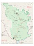
4 To the Valley rim. Miles Km. Miles Km. Half Moon Snow Creek Falls (top).. Grant Yosemite Ten May Olmsted Point Glen Beginning at scenic Olmsted Point, this trail leads hikers across Porcupine Creek rolling granite slabs into the Snow Creek drainage, joining the Snow Creek trail after a couple of miles. Backpackers can more readily access the north rim of Miles Km. Yosemite Valley and North Dome with its amazing vistas from Snow Creek Falls (top).. this trail. Yosemite Miles Km. Indian North Yosemite Falls (top).. Yosemite Valley (via Yosemite Falls).. Yosemite Valley (via Snow Creek).. Tuolumne Meadows (from Tenaya Lake to Tioga Pass). Tuolumne Meadows serves as a hub for summer backpacking opportunities in the park . Temperatures average 15 to 20 degrees Fahrenheit cooler than in Yosemite Valley, and, at 8,600 feet in elevation, the air is crisp, invigorating, and thin!
5 Tuolumne hikers enjoy a variety of popular routes and many of the trailheads are within a short distance of each other. Trails range from just a few miles to Sunrise Lakes to thousands of miles on the Pacific Crest Trail. Remember, any blue sky day can quickly turn ominous and gray. The Sierra are well known for their magnificent afternoon thundershowers; enjoy these from a safe location in good raingear. (The Tioga road closes due to snow, usually from sometime in November through late May or early June. There is no overnight parking on the Tioga road after October 15, please plan accordingly.). Trail Descriptions and Distances (One Way). Tuolumne Meadows Sunrise Lakes Cathedral Lakes This trail departs from western Tenaya Lake and follows This popular trail leads hikers into the heart of the Cathedral switchbacks up toward Sunrise Lakes or Clouds Rest.
6 Visitors Range and provides various loop trip options. can choose from several different loop options in this area Miles Km such as Merced Lake, Half Dome, or Cathedral Lakes. Cathedral Sunrise High Sierra Miles Km. Half Sunrise Little Yosemite Sunrise High Sierra Camp .. Yosemite Clouds Merced Half Tuolumne Elizabeth Lake Yosemite A pleasant day hike to a lake basin nestled beneath Unicorn Murphy Creek Peak. A cross-country route continues to Nelson lake. Miles Km. This trail follows Murphy Creek, then crosses open granite Elizabeth Lake (no camping).. slabs and wanders through Lodgepole forests to Polly Dome Nelson Lakes, May Lake, or Glen Aulin. Miles Km. Rafferty Creek->Vogelsang Polly Dome Glen This trail follows the Lyell Fork of the Tuolumne River through May sub-alpine meadows and then climbs along Rafferty Creek to Tuolumne Pass, Vogelsang, and destinations beyond.
7 Miles Km. Vogelsang High Sierra Merced Lake via Fletcher Merced Lake via Lewis Isberg Yosemite Valley via Fletcher Lyell Canyon Young Lakes via Glen Aulin This trail meanders through Lyell Canyon along the Lyell Fork Hikers along this trail travel through Tuolumne Meadows to of the Tuolumne River toward Donahue Pass to the south and Soda Springs and follow the Glen Aulin trail for a short while to Ireland Lake and Tuolumne Pass to the west. before ascending through lodgepole forest toward Ragged Miles Km. Peak and Young Lakes. Ireland Creek Trail Miles Km. Ireland Dog Lake (no camping).. Vogelsang High Sierra Young Yosemite Valley via Fletcher Donahue Mono/Parker Pass Devils Whitney This trail climbs through alpine meadows toward Mono and Parker Passes and Spillway Lake.
8 Trails continue into the Glen Aulin and Cold Canyon/Waterwheel Ansel Adams Wilderness toward Mammoth Lakes and beyond. Backpackers must cross into the Ansel Adams Wilderness This popular trail follows the Tuolumne River to Glen Aulin and before camping. beyond to the Grand Canyon of the Tuolumne River, up Cold Miles Km. Canyon into the north end of the park , or towards May Lake Spillway Lake (no camping).. and Ten Lakes. Mono Pass (no camping).. Miles Km. Parker Pass (no camping).. Twin Koip Peak Pass (no camping).. Glen Waterwheel ` Gaylor Lakes Pate white This trail climbs to alpine lakes basins from Tioga Pass. May Miles Km. Yosemite Valley via May Gaylor Lakes (no camping).. Virginia Great Sierra Mine (no camping).. Benson Young Mt.
9 Dana Young Lakes via Dog Lake This 13,000-foot peak is a popular destination not only for the challenging climb to the summit but the rewarding views from Hikers along this trail enjoy forests and high meadows with the top. This hike is a cross-country route. panoramic views of the Cathedral Range. Miles Km. Miles Km. Top of Mt. Dana (no camping).. Dog Young Yosemite Valley Some of the park 's most popular and strenuous trails wind up and past granite cliffs and roaring waterfalls to reach destinations on the north and south rims of the valley. From Yosemite Valley, you can hike to such well known destinations as El Capitan, Half Dome, Glacier Point, Yosemite Falls, and Vernal and Nevada Falls. For those interested in hiking trails with fewer people, the Snow Creek and Pohono Trails are fine choices with stunning views.
10 Trails start at 4,000 feet and often climb to above 7,000 feet in as little as four miles; pack plenty of food, water, and warm clothes to deal with these rapidly changing conditions. Many of the areas along the rim of the valley are day-use-only zones. Overnight hikers should check for camping restrictions. Trail Descriptions and Distances (One Way). Yosemite Valley Happy Isles / John Muir Trail Four Mile Trail This very popular trail climbs past waterfalls to Little Yosemite This trail travels up switchbacks from the Valley floor to Glacier Valley and is the start of the 211-mile John Muir Trail. Point and provides stunning vistas of Yosemite Valley en route. Continuing beyond Little Yosemite Valley brings hikers into the high country.