Transcription of TOPOGRAPHIE GENERALE
1 TOPOGRAPHIE GENERALEC entre de FormationSYNERGY SPACEPr sent Par : Pr. Mohammed ESSADIKIPlan de pr sentationPlan de pr sentation Objectifs G n ralit s MesuresLin airesOBJECTIFSGENERALITESMESURES LINEAIRESMESURES ANGULAIRES MesuresLin aires Mesures Angulaires Calcul des coordonn es Nivellement Calcul des Superficies cartographie Projet de TopographieCALCUL DES COORDONNEESNIVELLEMENTCALCUL DES SUPERFICIESCARTOGRAPHIEPROJET DE TOPOGRAPHIELes objectifsLes objectifsL ing nieur forestier est appel assurer les t ches suivantes : Etablissement de plans topographiques.
2 T ches de l Ing nieur forestier OBJECTIFSGENERALITESMESURES LINEAIRESMESURES ANGULAIRES Etablissement de plans topographiques ; Implantation d espaces forestiers ; Participation active la r daction des projets de march s publics ; Responsabilit de la surveillance des travaux et du contr le de l ex cution des march DES COORDONNEESNIVELLEMENTCALCUL DES SUPERFICIESCARTOGRAPHIEPROJET DE TOPOGRAPHIELes objectifsLes objectifsA la fin de ce cours, l l ve ing nieur doit tre capable de : Identifier les appareils et les instruments utiliser dans n importe quel cas de objectifs P dagogiques OBJECTIFSGENERALITESMESURES LINEAIRESMESURES ANGULAIRES utiliser dans n importe quel cas de figure.
3 Etablir des lev s topographiques ; Reporter des observations terrain sur plan ; Identifier les diff rents types de nivellement ; Implanter un alignement ;CALCUL DES COORDONNEESNIVELLEMENTCALCUL DES SUPERFICIESCARTOGRAPHIEPROJET DE TOPOGRAPHIEG n ralit sG n ralit sOBJECTIFSGENERALITESMESURES LINEAIRESMESURES ANGULAIRES1. DES COORDONNEESNIVELLEMENTCALCUL DES SUPERFICIESCARTOGRAPHIEPROJET DE DEFINITIONS DES SCIENCES GEODESIQUES4. AUTRES DEFINITIONS5. DIVISIONS DE LA TOPOGRAPHIE6. SYSTEMES DE PROJECTION OU SYSTEMES DEREPRESENTATION PLANEG n ralit sG n ralit s1- INTRODUCTIONOBJECTIFSGENERALITESMESURES LINEAIRESMESURES ANGULAIRESLa TOPOGRAPHIE , dans son sens le plus g n ral.
4 Estunesciencetr svastequiapourobjettoutcequiCALCUL DES COORDONNEESNIVELLEMENTCALCUL DES SUPERFICIESCARTOGRAPHIEPROJET DE TOPOGRAPHIE estunesciencetr svastequiapourobjettoutcequiconcerne l tablissement des plans et cartes ainsi queleur n ralit sG n ralit s1- INTRODUCTIONOBJECTIFSGENERALITESMESURES LINEAIRESMESURES ANGULAIRESLe Topographe: intervient dans diff rents projets d am nagement identifieleslimitesCALCUL DES COORDONNEESNIVELLEMENTCALCUL DES SUPERFICIESCARTOGRAPHIEPROJET DE TOPOGRAPHIE identifieleslimites mesure et value la propri t immobili re public oupriv e Indique tout ce qui est sur la surface R alise des plans parcellaires, des plans cot s,des profils, etc.
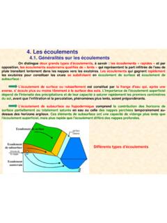
5 Tablit des cartes n ralit sG n ralit s2- BUT DE LA TOPOGRAPHIEOBJECTIFSGENERALITESMESURES LINEAIRESMESURES ANGULAIRESLa Topographieest la science qui a pour but derepr sentersurunefeuilleplaneuneportiondelaCA LCUL DES COORDONNEESNIVELLEMENTCALCUL DES SUPERFICIESCARTOGRAPHIEPROJET DE TOPOGRAPHIE repr sentersurunefeuilleplaneuneportiondelasu rface terrestre une chelle donn n ralit sG n ralit s2- BUT DE LA TOPOGRAPHIEOBJECTIFSGENERALITESMESURES LINEAIRESMESURES ANGULAIRESU necarterepr sente une surface tr s tendueg n ralement une chelle tr s senteunesurfaceplusrestreinteet CALCUL DES COORDONNEESNIVELLEMENTCALCUL DES SUPERFICIESCARTOGRAPHIEPROJET DE TOPOGRAPHIEU nplanrepr senteunesurfaceplusrestreinteet une chelle tr s n ralit sG n ralit s2- BUT DE LA TOPOGRAPHIEOBJECTIFSGENERALITESMESURES LINEAIRESMESURES ANGULAIRESU necarterepr sente une surface tr s tendueg n ralement une chelle tr s senteunesurfaceplusrestreinteet CALCUL DES COORDONNEESNIVELLEMENTCALCUL DES SUPERFICIESCARTOGRAPHIEPROJET DE TOPOGRAPHIEU nplanrepr
6 Senteunesurfaceplusrestreinteet une chelle tr s appelle chelle, le rapport de similitude de lafigure du plan la figure de terrain ; autrementdit c est le rapport entre la distance qui s paredeux points sur la carte et la distancehorizontale correspondante sur le terrain. Cerapport s exprime par une fraction simple dont lenum rateur est n ralit sG n ralit s3- DEFINITIONS DES SCIENCES GEODESIQUESOBJECTIFSGENERALITESMESURES LINEAIRESMESURES ANGULAIRESP lusieurs disciplines sont li es directement la TOPOGRAPHIE et sont group es dans les Sciences G od siques, ou plus r cemment la G DES COORDONNEESNIVELLEMENTCALCUL DES SUPERFICIESCARTOGRAPHIEPROJET DE TOPOGRAPHIEG od siques, ou plus r cemment la G disciplines sont les suivantes.
7 G n ralit sG n ralit s3- DEFINITIONS DES SCIENCES GEODESIQUESOBJECTIFSGENERALITESMESURES LINEAIRESMESURES ANGULAIRESP lusieurs disciplines sont li es directement la TOPOGRAPHIE et sont group es dans les Sciences G od siques, ou plus r cemment la G DES COORDONNEESNIVELLEMENTCALCUL DES SUPERFICIESCARTOGRAPHIEPROJET DE TOPOGRAPHIEG od siques, ou plus r cemment la G disciplines sont les suivantes : G od sie Photogramm trie cartographie T l d tection Syst mes d Information G ographiqueG n ralit sG n ralit s3- DEFINITIONS DES SCIENCES GEODESIQUESOBJECTIFSGENERALITESMESURES LINEAIRESMESURES ANGULAIRESG od sie: science qui a pour but de transformer la surface courbe de l ellipso de en surface DES COORDONNEESNIVELLEMENTCALCUL DES SUPERFICIESCARTOGRAPHIEPROJET DE TOPOGRAPHIEG n ralit sG n ralit s3- DEFINITIONS DES SCIENCES GEODESIQUESOBJECTIFSGENERALITESMESURES LINEAIRESMESURES ANGULAIRESP hotogramm trie.
8 Science qui consiste l tude et la d finition pr cise des formes, des dimensions et la position dans l espace d un objet quelconque en utilisant seulement des mesures faites sur une ou CALCUL DES COORDONNEESNIVELLEMENTCALCUL DES SUPERFICIESCARTOGRAPHIEPROJET DE TOPOGRAPHIE utilisant seulement des mesures faites sur une ou plusieurs photographies a riennes ou terrestres. Le document obtenu partir de la restitution des photographies s appelle la st r n ralit sG n ralit s3- DEFINITIONS DES SCIENCES GEODESIQUESOBJECTIFSGENERALITESMESURES LINEAIRESMESURES ANGULAIRESCALCUL DES COORDONNEESNIVELLEMENTCALCUL DES SUPERFICIESCARTOGRAPHIEPROJET DE TOPOGRAPHIEG n ralit sG n ralit s3- DEFINITIONS DES SCIENCES GEODESIQUESOBJECTIFSGENERALITESMESURES LINEAIRESMESURES ANGULAIRESC artographie.
9 C est l ensemble des tudes et op rations scientifiques et artistiques intervenant partir des r sultats d observations directes, ou l exploitation d un document en vue de l laboration de cartes, plans et CALCUL DES COORDONNEESNIVELLEMENTCALCUL DES SUPERFICIESCARTOGRAPHIEPROJET DE TOPOGRAPHIE document en vue de l laboration de cartes, plans et autres mode d expression de la surface n ralit sG n ralit s3- DEFINITIONS DES SCIENCES GEODESIQUESOBJECTIFSGENERALITESMESURES LINEAIRESMESURES ANGULAIREST l d tection: c est la science et l art d obtenir l information concernant un objet ou un ph nom ne par des mesures CALCUL DES COORDONNEESNIVELLEMENTCALCUL DES SUPERFICIESCARTOGRAPHIEPROJET DE TOPOGRAPHIEph nom ne par des mesures effectu es distances.
10 Les donn es t l d tect es peuvent tre analys es et manipul es l aide d un traitement d images pour extraire l information d sir e. G n ralit sG n ralit s3- DEFINITIONS DES SCIENCES GEODESIQUESOBJECTIFSGENERALITESMESURES LINEAIRESMESURES ANGULAIRESSyst mes d Information G ographiques (SIG): le SIG est un syst me compos de mat riel et de logiciels ainsi que de proc dures pour supporter l acquisition, la gestion, la manipulation, la mod lisation et la CALCUL DES COORDONNEESNIVELLEMENTCALCUL DES SUPERFICIESCARTOGRAPHIEPROJET DE TOPOGRAPHIE gestion, la manipulation, la mod lisation et la repr sentation de donn es spatiales pour r soudre les probl mes complexes de planification et d am : Syst me d aide pour la prise de d cisionG n ral