Transcription of Tropical Cyclones - National Weather Service
1 Tropical Cyclones Hurricane Earl, September 1, 2010/NOAA. A PREPAREDNESS GUIDE. DEPARTMENT OF COMMERCE. National Oceanic and Atmospheric Administration National Weather Service Revised March 2011. What is a Tropical Cyclone? Tropical Cyclones are among nature's most powerful and destructive phenomena. If you live in an area prone Understanding the Terminology to Tropical Cyclones , you need to be prepared. Even areas well away from the coastline can be threatened A Tropical cyclone is a rotating, organized system by destructive winds, tornadoes and flooding from these of clouds and thunderstorms that originates over storms. How great is the danger? For 1970-2010, the Tropical or subtropical waters and has a closed average numbers per year were as follows: low-level circulation.
2 Tropical Cyclones rotate counterclockwise in the Northern Hemisphere. Atlantic Ocean, Caribbean or Gulf of Mexico: They are classified as follows: 11 Tropical storms, 6 of which became hurricanes East Pacific Ocean: 15 Tropical storms, 8 of which Tropical Depression A Tropical cyclone with became hurricanes maximum sustained winds of 38 mph (33 knots). Central Pacific Ocean: 4 Tropical storms, 2 of or less. which became hurricanes Tropical Storm A Tropical cyclone with maximum sustained winds of 39 to 73 mph Over a typical 2-year period, the coastline is struck (34 to 63 knots). by an average of 3 hurricanes, 1 of which is classified as Hurricane A Tropical cyclone with maximum a major hurricane.
3 Sustained winds of 74 mph (64 knots) or higher. In the western north Pacific, hurricanes are While hurricanes pose the greatest threat to life and called typhoons; similar storms in the Indian property , Tropical storms and depressions also can Ocean and South Pacific Ocean are be devastating. Floods from heavy rains and severe called Cyclones . Weather , such as tornadoes, can cause extensive Major Hurricane A Tropical cyclone with damage and loss of life. For example, Tropical Storm maximum sustained winds of 111 mph (96 knots). Allison produced over 40 inches of rain in the Houston or higher, corresponding to a Category 3, 4 or 5. area in 2001, causing about $5 billion in damage and on the Saffir-Simpson Hurricane Wind Scale.
4 Taking the lives of 41 people. Tropical Cyclones forming between 5 and 30 degrees north latitude typically move toward the west. Cyclones reach latitudes near 30 degrees north , they Sometimes the winds in the middle and upper levels often move northeast. of the atmosphere change and steer the cyclone toward the north and northwest. When Tropical Hurricane seasons and their peaks are as follows: Atlantic and Caribbean: June 1 to November 30. with peak season mid- August to late October. Central Pacific (Hawaii): June 1 to November 30. with peak season from July to September. East Pacific: May 15 to November 30. Western north Pacific: Tropical Cyclones can strike year round Tropical cyclone formation regions with mean tracks/NWS JetStream Online School 2.
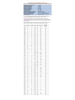
5 Saffir-Simpson Hurricane Wind Scale The Saffir-Simpson Hurricane Wind Scale is a 1 to 5 rating based on a hurricane's sustained wind speed. This scale estimates potential property damage. Hurricanes reaching Category 3 and higher are considered major hurricanes because of their potential for significant loss of life and damage. Category 1 and 2 storms are still dangerous, however, and require preventative measures. In the western north Pacific, the term super typhoon is used for Tropical Cyclones with sustained winds exceeding 150 mph. Saffir-Simpson Hurricane Wind Scale for the Continental United States Scale Sustained Types of Hurricanes Number Winds Damage Due to (Category) (MPH) Hurricane Winds 1 74-95 Very dangerous winds will produce some damage: Well-constructed Dolly (2008).
6 Frame homes could have damage to roof, shingles, vinyl siding and on South Padre gutters. Large branches of trees will snap and shallowly rooted trees may Island, Texas be toppled. Extensive damage to power lines and poles likely will result in power outages that could last a few to several days. 2 96-110 Extremely dangerous winds will cause extensive damage: Frances (2004). Well-constructed frame homes could sustain major roof and siding in coastal Port damage. Many shallowly rooted trees will be snapped or uprooted and St. Lucie, Florida block numerous roads. Near-total power loss is expected with outages that could last from several days to weeks. 3 111-130 Devastating damage will occur: Well-built framed homes may incur Ivan (2004).
7 Major damage or removal of roof decking and gable ends. Many trees will in coastal Gulf be snapped or uprooted, blocking numerous roads. Electricity and water Shores, Alabama will be unavailable for several days to weeks after the storm passes. 4 131-155 Catastrophic damage will occur: Well-built framed homes can sustain Charley (2004). severe damage with loss of most of the roof structure and/or some in coastal Punta exterior walls. Most trees will be snapped or uprooted and power poles Gorda, Florida downed. Fallen trees and power poles will isolate residential areas. Power outages will last weeks to possibly months. Most of the area will be uninhabitable for weeks or months.
8 5 >155 Catastrophic damage will occur: A high percentage of framed homes Andrew (1992). will be destroyed, with total roof failure and wall collapse. Fallen trees in coastal parts and power poles will isolate residential areas. Power outages will last of Cutler Ridge, for weeks to possibly months. Most of the area will be uninhabitable for Florida weeks or months. For more information on the Saffir-Simpson Hurricane Wind Scale, go to: For more information on the Saffir-Simpson Hurricane Wind Scale as it affects Hawaii, go to: Wind damage from Hurricane Charley, August 2004, Orlando, FL/Orlando Sentinel, copyright 2004. 3. Hurricane Hazards Storm Surge/Tide Storm surge and large waves produced by hurricanes pose the greatest threat to life and property along the coast.
9 STORM SURGE is an abnormal rise of water generated by a storm's winds. Storm surge can reach heights well over 20 feet and can span hundreds of miles of coastline. In the northern hemisphere, the highest surge values typically occur in the right front quadrant of a hurricane coincident with onshore flow; in the southern hemisphere, the left front quadrant. More intense and larger hurricanes produce higher surge. In addition, shallower offshore waters contribute to higher storm surge inundation. Storm surge is by far the greatest threat to life and property along the immediate coast. STORM TIDE is the water level rise during a storm due to the combination of storm surge and the astronomical tide.
10 For example, if a hurricane moves ashore at a high tide of 2. feet, a 15 foot surge would be added to the high tide, creating a storm tide of 17 feet. The combination of high winds and storm tide topped with battering waves can be deadly and cause tremendous property damage along an area of Before and after Hurricane Ike on the Bolivar coastline hundreds of miles wide. Peninsula, TX, September 2008/USGS. The destructive power of storm surge and large battering waves can result in loss of life, buildings destroyed, beach and dune erosion and road and bridge damage along the coast. Storm surge can travel several miles inland. In estuaries and bayous, salt water intrusion endangers public health and the environment.