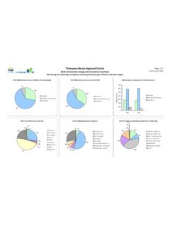
Transcription of Tsunami Notification Zone E for British ... - British Columbia
1 !!!!"!"""!!<!<!<!<"!.""""!<!!<"""""!!.!. !.!.!.!.!.!.!.!.!O!O!O!O!O!O!O!O!O!OQuad raIslandCortezIslandNelsonIslandGambierI slandEast ThurlowIslandWest ThurlowIslandHardwickeIslandKnightInletB uteInletPacific Rim National ParkReserve of CanadaPacific RimNational ParkReserve ofCanadaJuan de Fuca Provincial ParkB r i t i s h C o l u m b i a , C a n a d aW a s h i n g t o n , U n i t e d S t a t e s o f A m e r i c aDUNCANPARKSVILLEPORT ALBERNICOURTENAYPORTMOODYRICHMONDVANCOUV ERNANAIMOVICTORIABURNABYSURREYU clueletTofinoSquamish DMPowell RiverCampbell RiverSecheltSaanichSooke BowenIslandLangfordEsquimaltNorthSaanich SidneyLadysmithComoxGibsonsQualicum BeachSaywardTahsisLionsBayPembertonCumbe rlandGold RiverPenderIslandPortRenfrewMill BaySaturnaIslandMayneIslandSaltspringIsl andCowichan BayStz'uminus (641)SaltairGabriolaIslandBamfieldHornby IslandFanny BayDenmanIslandUnion BayMarktosisOpitsatTsawwassenLadnerPort MellonRoberts CreekBritanniaBeachGarden BaySaltery BayLang BayLundBirkenGalianoIslandBig BayRoystonNanoose BayLantzvilleCedarCeepeeceeHecateYuquotN ootkaBoat BasinHesquiatChetarpeWhyacClo-ooseEcoole EgmontMcNab CreekThormanbyIslandWoodfiberSetonPortag ePioneerMineGoldBridgeKokishTelegraphCov eBonesBayKarlukweesMinstrelIslandEcho BayThompsonSoundPortNevilleSullivanBayKi ngcomeShelter PointOyster RiverQualicumEarlsCoveMadeira ParkGreen CoveLandingQuinaquilthQuisitisIlthpayaKo otowisQuortsoweOinimitisMountCurriePembe rtonMeadowsCreeksideGatesDistrict ofHighlandsEastSookeNEW WESTMINSTERS ecret CoveCroftonCracroftBuckley BayChemainusJordan RiverShirleyWestVancouverNORTH VANCOUVERC entralSaanichNorthVancouverDMDeltaWHITE ROCKALBERNI-CLAYOQUOTREGIONAL
2 DISTRICTCAPITALREGIONAL DISTRICTCARIBOO regional DISTRICTMOUNT WADDINGTONREGIONAL DISTRICTFRASER VALLEYREGIONALDISTRICTCOWICHANVALLEY REGIONALDISTRICTGREATERVANCOUVERREGIONAL DISTRICTNANAIMOREGIONALDISTRICTPOWELL RIVERREGIONALDISTRICTSUNSHINECOAST REGIONALDISTRICTSQUAMISH-LILLOOETREGIONA L DISTRICTCOMOX VALLEYREGIONALDISTRICTSTRATHCONA regional DISTRICTSTRATHCONAREGIONAL DISTRICTMOUNT WADDINGTONREGIONAL DISTRICTN ational Tsunami Warning Center(NTWC) BreakpointBC-Washington BorderOak BayUSAUSAWe Wai Kai Nation -Cape Mudge(623)LasquetiIslandSavaryIsland(656 )(658)(660)(649)(554)(635)(627)(636)Dzaw ada'enuxw(625)Kwicksutaineuk-ah-kwaw-ah- mish(629)Mamalilikulla-Qwe'Qwa'Sot'Em(63 7)Tlowitsis(628)Kwiakah(553)Klahoose(552 )Xwemalhkwu-Homalco(624)K'omoks(665)Tses haht(664)Hupacasath(555)Squamish(549)Tse il-Waututh(550)Musqueam(569)Semiahmoo(64 8)Snuneymuxw(650)PenelakutLyackson(646)( 655)Tseycum(647)Malahat(654)Tsawout(653) Tsartlip(652)Pauquachin(644)Songhees(640 )BeecherBay(657)T'Sou-ke(662)Ditidaht(66 8)UclueletToquaht(666)(667)Uchucklesaht( 663)Huu-ay-aht(659)Ahousaht(661)Hot SpringsCove(630)Mowachaht/MuchalahtGwawa enukTribeDa'naxda'xwSliammonHesquiahtNan ooseTla-o-qui-ahtCowichan(642)Pacheedaht Halalt (645)
3 V a n c o u v e rI s l a n dT e x a d aI s l a n dTsunami Notification Zone E for British Columbia Communities withinTsunami Notification Zone ECBBig BayBones BayBrittania BeachBowen IslandBuckley BayBurnabyCampbell RiverCedarCentral SaanichChemainusComoxCortez IslandCourtenayCowichanCowichan BayCracroftCroftonCumberlandDeltaDenman IslandDistrict of HighlandsDuncanEarls CoveEast Thurlow IslandEcho BayEgmontFanny BayGabriola IslandGaliano IslandGambier IslandGarden BayGibsonsHalaltHardwicke IslandHornby IslandK'omoks (Comox)KarlukweesKlahooseKwiakahLadnerLa dysmithLang BayLangfordLantzvilleLasqueti IslandLyacksonLions BayLundMadeira ParkMalahatMayne IslandMcNab CreekMill BayMinstrel IslandMusqueamSaywardSecheltSecret CoveSemiahmooShelter PointSliammonSnuneymuxvwSquamishSquamish DMSurreyStz`uminusTexada IslandThompson SoundThormanby IslandTlowitsisTsartlipTsawwaassenTseil- WaututhTseycumUnion BayVancouverWe Wai Kai Nation - Cape MudgeWest Thurlow IslandWest VancouverWhite RockWoodfiberXemalhkwu - HomalcoDENanaimoNanoose BayNelson IslandNew WestminsterNorth SaanichNorth Vancouver CityNorth Vancouver DMOyster RiverParksvillePauquachinPenelakutPender IslandPort MellonPort MoodyPort NevillePowell RiverQuadra IslandQualicumQualicum BeachRichmondRoberts CreekRoystonSaltairSaltery BaySaltspring IslandSaturna IslandSavary IslandCapital regional DistrictComox Valley regional
4 DistrictCowichan Valley regional DistrictGreater Vancouver regional DistrictMount waddington regional DistrictNanaimo regional district Powell River regional DistrictStrathcona regional DistrictSquamish-Lillooet regional DistrictSunshine Coast regional district NotificationsAlert LevelThreatActionWarningAdvisoryWatchInf ormationInundating wave possibleStrong currents likelyDanger level not known yetMinor waves at mostFull evacuation suggestedStay away from the shoreStay alert for more informationNo action suggested01020304050 Kilometres1:400,000 LegendProduced for:Produced for:City"!. district Municipality!Town!<VillageUnincorporated /Indian Reserves!OTide GaugeParksRegional DistrictDenotes First NationCommunity office(670) Tsunami Notification ZonesTsunamis are rare but serious events. Many areas of coastal may be threatened in the eventof a Tsunami .
5 However, it is generally accepted by scientific and technical experts that Victoria,eastern Vancouver Island, Vancouver and the lower mainland are low-risk areas. To ensure that all communities receive appropriate Tsunami messaging, that is easilyunderstandable using provincial landmarks, Emergency Management BC has divided theprovince into five (5) zones for Notification purposes. These zones are reflected on this mapin different colours and the letters A, B, C, D and E. All Tsunami notifications prepared by the Province will refer to these five zones . Each of the fivedesignated zones includes all islands and inlets within the location Path: W:\ilmb\PEP\projects\PECC\ Tsunami \PEP_ts unami_maps\Inundation zones \arcGISprojects\ : 30/11/2015 Produced by:Produced by: Tsunami Notification ZonesZONE A - THE NORTH COAST AND HAIDA GWAII ZONE B - THE CENTRAL COAST AND NORTHEAST VANCOUVER ISLAND COAST INCLUDING KITIMAT, BELLA COOLA, AND PORT HARDYZONE C - THE OUTER WEST COAST OF VANCOUVER ISLAND FROM CAPE SCOTT TO PORT RENFREW ZONE D - THE JUAN DE FUCA STRAIT FROM JORDAN RIVER TO GREATER VICTORIA INCLUDING THE SAANICH PENINSULA ZONE E - THE STRAIT OF GEORGIA INCLUDING THE GULF ISLANDS, GREATER VANCOUVER AND JOHNSTONE STRAITBCADE