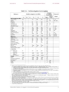
Transcription of TUTORIAL Locations & Mapping - ESdat
1 TUTORIAL - Locations & MappingFor use with ESdat version 5 (version 5 software updates available from ) Using the ESdat Environmental Database System Function TutorialLocations and @EarthScience Information SystemPage |1 Function TUTORIAL - Locations and MappingTable ofContentsTable of and editing Locations and One: Exercise 1: Bulk Import using Import 2: Specifying the co-ordinate 3: Adding a vector 4: Changing layer display Coordinate 5: Assigning a coordinate system to a vector Web Mapping Service Layers and Mapping 6: Adding Open Street Map data to the and moving ESdat Locations directly on the 7: Adding a Location directly onto the 8: Changing the position of an existing location on the labels for Locations (data points) on to ArcMap / MapInfo /Google 9: Exporting to Google 10: Exporting to ArcMap / TutorialLocations and @EarthScience Information SystemPage |2 SummaryThis TUTORIAL : examinesthe use ofESdat to manageand/or createthe following data types.
2 Olocation datain either bulk or individual forms( a surveyor)ovectorbasemapsoweb based aerial imagery uses theSample Hydrogeology and Contamdatabase (and therefore can be usedwith the demonstration version of ESdat ) is completed using the Access version of ESdat requires approximately 90-120minutes to completePre-requisitesFor a full list of the tutorials available for use with ESdat , please see theTutorial LearningFollowing completion of this TUTORIAL , the user will have developed skills in the following: Management ofgeographical coordinate datawithin ESdat Using the ESdat Mapping functions tocreate,displayand editlocations Exporting data from ESdat to third party softwarepackagesIt is assumed the user has previously completed: TUTORIAL 2 Introducing ESdat Function TUTORIAL : Importing and Editing DataFunction TutorialLocations and @EarthScience Information SystemPage |3 IntroductionAs described inFunctional TUTORIAL :Importing, Editing and Deleting Data,aLocation Code(or LocCodein the Access version)is a unique identifier(or Primary Key).
3 A Location Codeisa unique codeused within ESdattoassociateasingle unique location( boreholeor surface soil sample) with associatedattributeinformation(such ascoordinatesand elevationdata).Thisattributeinformationa ssociated with alocationis stored within aDataTablein theproject database (called theLocationData Table).By assigningthe same(unique)Location Code to anyotherdataimported into ESdat , theattributeinformation will also be associatedwith the importeddata( chemistry resultsare associated with a the coordinates of a particular groundwater well).Otherdifferent data types managed by ESdat are stored within specificData Tables withinESdat. Examples of different data typesincludegroundwater welldetails,waterleveldata,geological or borehole examplerelationship betweentheLocation Tableand other information held inDataTables withinESdatisshownin the the Location Code forms the cruciallink (Location Code is abbreviated in the Access versionLocCodeand toLocation_CodeinSQL).
4 Usersgenerallyprefertoassign ameaningful Location Code (such as BH01).In general, data (such aschemistry data or water levels) cannot be imported to ESdat unlessacorresponding LocationCode (referred to as a Parent Record)has previouslybeencreatedwithin TutorialLocations and @EarthScience Information SystemPage |4 However, when necessary,LocationCodes canautomaticallybe generatedby ESdatduringthe import Missing Parent Recordswhen importing new data,anewLocationCodeentry will becreatedifone does not already exist within the other Locationattributeinformation such as co-ordinates will then need tosubsequentlybe added to thatnewly process is described in detail in the Function TUTORIAL :Importing,Editingand TutorialLocations and @EarthScience Information SystemPage |5 Importingand editing Locations and co-ordinatesThe following exercise comprisesimportingsome newLocation data intoa assumedreaders have completed the previous tutorials describing how to seta newdatabase in assistance in setting up a new database, refer data can be imported intoESdatinthreeways: bulkimport( supplied from a surveyor).
5 Or addition of Locations directly into theLocations Data Viewin ESdat addition oflocationsdirectly ontoa map in ESdatThe method of bulk importof dataisdetailed in the directlyto a map is covered laterin this locationstobe added to thenewESdat Site/Projectcomprises the TutorialLocations and @EarthScience Information SystemPage |6 ExercisesExercise One:Exercise1:Bulk Import using Import templates Click on theImportview typebutton(located top section of the ESdat window) FromtheBlank Import Templatesarea(blue area), selectLocationsto open aBlankImport Templatein Excel Copy/enterthetabulateddatafrom the previous pageinto therelevant fields (cells)within theBlank Import Template Navigate to theAdd Instab at the top of the Excel window ClicktheImportbuttontoopen theUpload Datadialogue box ClickImportto import the new data(as shown in the figure below)Successfully importedcellswillshaded light green(as shown above).
6 ClickClosewithin theUpload Datadialogue box Close theExcel template (don t save) Return toESdat Navigate totheDataViewsview type Click on theblueLocationsdata typebutton(directly belowOpenProject, top left ofthe window)to refresh the data Confirm that the dataimportedis presentin the databaseFunction TutorialLocations and @EarthScience Information SystemPage |7 Exercise 2: Specifying the co-ordinate systemThe coordinate system for the data in ESdat is specified in theProjectData Tablein theAccess Versionof ESdat (ortheSiteData Table for theSQL version). Hover the mouse over theDataTablesbutton (top rightwhile inData Views) Click on theProjecttable (Access)Informationabout theProject will now be the Coordinate System for thisdataset is blank (unless you specified it on project setup).
7 SelectEdit Modeby clicking on theAllow Editingiconfrom the far left verticaltool bar(the icon will go red) Click within the cell directly below the Column (Field) HeadingCoordinate_Systemand expand the drop down list that appears If required, widenthe columnlabelledCoordinate_System, so all values in the drop-downare visibleFrom thedrop-down selectWGS_84(these co-ordinates arelatitude/longitude) TurnEdit modeoff by clicking theAllow Editingicon again(the icon will nolonger be red)Function TutorialLocations and @EarthScience Information SystemPage |8 BasemapsExercise3: Adding avectorbasemapThe following steps describe the method to add a basemapto ESdat (such as an aerialphotograph)above which Locations (such as boreholes)and associated data can bepresented. Select theLocationsData-TypebuttonNote that the new Locations are shown together with Locations that were already presentwithin the database.
8 A filter must be applied to focus only upon BH1 BH5. Within the Column (Field) labelledLocCode, doubleclick on the cells containing BH1,BH2, BH3, BH4 &BH5A filter code will be created in the Filter Area. ClickApply Filter(directly below the blueSoil/Rock Chemistrybutton)The data should now be filtered to only show BH1-BH5, as shown in the figure below. SelecttheMap panel(centreof three grey tabs mid screen) Click theZoom to Selected Layerbutton(from the far left vertical toolbar) Locations BH1-BH5 shouldnowbe basemap layer can be added(imported) to the map windowin mostcommon GIS formatsusing theAddbutton(located to the top right of the Map area).Alternatively,a new layer can bedirectlydrawn in following describes theprocess to draw a new site boundary. Click theNewbutton (immediatelyright of theAddbutton) Save this layerwith file nametest(save at a convenient location, such the desktop)(Note: the DXF format is the most versatile for drawing, however MapInfo format files (.))
9 Mif)can also be createdin the same way)After saving the file, intheMap Layerslistvisible tothe rightof the TutorialLocations and @EarthScience Information SystemPage |9 The following steps will Click theEditButtonlocatedimmediatelyabovetheM apLayerslist to the topright of the map(note thisEdit Buttonis distinct from that used to edit data usedin Exercise 2)Clicking the edit button will open additionalpoint, line and polygon creation andeditingbuttons, as shown below(hovering over the buttons in ESdat will produce a small popupwindow with button names): ClickAdd PolygonClicking at a point on the map will create a single node. Clicking at a second point will createa second node joined to the first by a line. Clicking at a thirdpoint will create a polygon andso on.
10 Draw apolygon surroundingthe boreholeson the map ClickSaveFunction TutorialLocations and @EarthScience Information SystemPage |10 Exercise4: Changing layer display propertiesDouble clicking on alayerwithin theMap Layerlist will open a dialogue box(an example isshown below).Variousoptions allow editing oflayer properties, such as line colour, dashedlines and so on. Double clickthe layertestfrom theMap Layers(shown below)to open a dialoguebox Select theAreatab(a polygon corresponds to an area) SelecttheOutlinesub-tab Change the Color toRedFunction TutorialLocations and @EarthScience Information SystemPage |11 ClickOKThe outline of thepolygonwill be shown in red(as shown in the image below). Explore theoptions here and note the changes, prior to closing the dialogue more information on base maps, see: TutorialLocations and @EarthScience Information SystemPage |12 BasemapCoordinate SystemsESdat has the ability to overlay dataand layersin imagery basemaps (such asaerial photographs or satellite imagery) need to be geo-referenced before viewingin imagery formats contain the co-ordinate system within the file (such asecwformat)and others require associatedworld files(such astiffformat).